Dornbirn
| Dornbirn | ||
|---|---|---|
|
| ||
| ||
 Dornbirn Location within Austria | ||
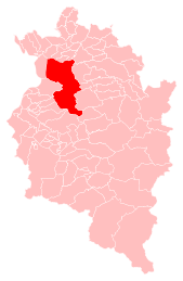
Location of Dornbirn within Vorarlberg
| ||
| Coordinates: 47°24′50″N 09°44′40″E / 47.41389°N 9.74444°ECoordinates: 47°24′50″N 09°44′40″E / 47.41389°N 9.74444°E | ||
| Country | Austria | |
| State | Vorarlberg | |
| District | Dornbirn | |
| Government | ||
| • Mayor | Andrea Kaufmann (ÖVP) | |
| Area | ||
| • Total | 120.97 km2 (46.71 sq mi) | |
| Elevation | 437 m (1,434 ft) | |
| Population (1 January 2016)[1] | ||
| • Total | 48,067 | |
| • Density | 400/km2 (1,000/sq mi) | |
| Time zone | CET (UTC+1) | |
| • Summer (DST) | CEST (UTC+2) | |
| Postal code | 6850 | |
| Area code | 05572 | |
| Vehicle registration | DO | |
| Website | www.dornbirn.at | |
Dornbirn [ˈdɔʁnbɪʁn] is a city in the Austrian state of Vorarlberg. It is the administrative centre for the district of Dornbirn, which also includes the town of Hohenems, and the market town Lustenau.
Dornbirn is the largest city in Vorarlberg and the tenth largest in Austria. It is an important commercial and shopping centre.
Geography
Location
Dornbirn is located in western Vorarlberg at 437 metres above sea level in the Alpine Rhine Valley, at the foot of the Karren mountain, part of the Bregenz Forest Mountain chain at the edge of the Eastern Alps. It is near the borders to Switzerland, Germany and Liechtenstein. The Dornbirner Ach river flows through the town and later into Lake Constance.
Municipal structure
Dornbirn once consisted only of 4 "quarters": Markt, Hatlerdorf, Oberdorf and Haselstauden. By the 20th century Dornbirn had annexed two formerly independent communities to the west: Rohrbach and Schoren, thus bringing the total number of districts to 6.
Neighbouring municipalities
The Town of Dornbirn constitutes almost 70% of the surface of the district Dornbirn and has numerous borders to other municipalities. As well as bordering on the two other municipalities in the Dornbirn district (Hohenems and Lustenau), the town shares borders with 15 municipalities of the Bregenz District: (Lauterach, Wolfurt, Schwarzach, Bildstein, Alberschwende, Schwarzenberg, Reuthe, Mellau, Damüls) and four with the Feldkirch District: (Laterns, Zwischenwasser, Viktorsberg, Fraxern).
History
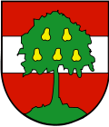
The earliest evidence of human presence in the Dornbirn area can be dated from the Mesolithic era. The name "Dornbirn" derives from 'torrin puirron', meaning the 'Settlement of Torro' (the name of an Alemannic farmer living there) and thus has nothing to do with "pears" (German "Birnen"), although this fruit is prominently portrayed on the town emblem. This name is mentioned for the first time in 895, in a document from St. Gallen (Switzerland).
Dornbirn became part of the Habsburg Monarchy in 1380. In 1793 it was elevated to a market community. It was not given municipal status until 1901. In 1932 the mountain village of Ebnit was annexed. In 1969 Dornbirn became the seat of the new Dornbirn district administrative authority.
Population
| Historical population | ||
|---|---|---|
| Year | Pop. | ±% |
| 1869 | 8,707 | — |
| 1880 | 9,464 | +8.7% |
| 1890 | 10,810 | +14.2% |
| 1900 | 13,193 | +22.0% |
| 1910 | 16,320 | +23.7% |
| 1923 | 14,481 | −11.3% |
| 1934 | 16,650 | +15.0% |
| 1939 | 17,572 | +5.5% |
| 1951 | 22,532 | +28.2% |
| 1961 | 28,075 | +24.6% |
| 1971 | 35,113 | +25.1% |
| 1981 | 38,641 | +10.0% |
| 1991 | 40,735 | +5.4% |
| 2001 | 42,301 | +3.8% |
| 2011 | 45,605 | +7.8% |
| 2014 | 46,883 | +2.8% |
| Largest groups of foreign residents | |
| Nationality | Population |
|---|---|
| 1,813 | |
| 1,209 | |
| 460 | |
| 347 | |
| 239 | |
Politics
Municipal Council
The Dornbirn Municipal Council has 36 seats and the following party mandates:
- 21 Austrian People's Party (ÖVP)
- 8 Social Democratic Party of Austria
- 4 Die Grünen
- 3 Freedom Party of Austria
The current mayor (since 2013) is Andrea Kaufmann (ÖVP).
International relations
Dornbirn has town partnerships with
Well-known citizens of Dornbirn
- Karl Cordin, (born 1948), ski racer
- Francis Martin Drexel (1792–1863), Philadelphia banker and artist
- Margret Dünser, (1926–1980), journalist
- Ingrid Eberle, (born 1957), ski racer
- Elfi Graf, (born 1952), singer
- Yvonne Meusburger, (born 1983), WTA tennis player
- Tamira Paszek, (born 1990), WTA tennis player
- Aaron Pilsan, (born 1995), pianist
- Gerold Ratz (1919–2006), former Landesstatthalter of Vorarlberg
- Wolfgang Rümmele (born 1946), mayor of Dornbirn 1999-2013
- Karl Aubert Salzmann (1876–1934), president of Federal Council (Austria)
- Johann Georg Waibel (1828–1908), mayor of Dornbirn 1869-1908, member of Reichsrat and Landtag
Notable architecture
The Messestadion is an indoor sporting arena located in Dornbirn, and home to the local ice hockey team.
Economy
Vorarlberg's regional studio of the ORF (Austrian Broadcasting Corporation) is located in Dornbirn.
Zumtobel Lighting Group is an ATX traded company based in Dornbirn. Many other large companies are situated there. The town was formerly a major centre of the textile industry, which has been in decline since the 1980s.
Transport
Located in the middle of the Rhine valley, Dornbirn is an important junction of regional and interregional bus lines, connecting Bregenz to the north, Feldkirch to the south, and the Bregenz Forest to the east. The A14 Rheintal freeway/motorway (Autobahn) passes by to the west. The Achrain tunnel, opened in 2009, directly connects Dornbirn/Haselstauden with the Bregenz Forest - Alberschwende region. The town has an excellent network of municipal buses.
Dornbirn's railway station connects is an important stop for all trains from west to east Austria.
A small airport is located at nearby Hohenems.
Education
Educational institutions in Dornbirn include the Fachhochschule Vorarlberg University of Applied Sciences, two General Education Secondary Schools, and a Higher Technical Vocational College (Höhere Technische Lehranstalt).
Sports
One of the most important sportive institutions in Dornbirn is the RHC Dornbirn, one of the most powerful Austrian Rink Hockey teams. In 2010 it hosted the 2010 Rink Hockey Men's B World Championship.
Baseball & Softball Club Dornbirn was founded in 1990, and has won the Austrian title twice. BSC Dornbirn consists of one youth team, two men's teams, and two women's teams. www.indians.at for more information.
Dornbirn hosted the World Gymnaestrada event in 2007 and will do so again in 2019.[2]
References
External links
| Wikimedia Commons has media related to Dornbirn. |
| Wikisource has the text of the 1911 Encyclopædia Britannica article Dornbirn. |
| Wikivoyage has a travel guide for Dornbirn. |
- Dornbirn
- College of Applied Sciences
- Natural History Museum (Inatura)
- Rolls Royce Museum
- Roller Hockey Dornbirn Club
- Tiscover Dornbirn
- Spielboden Cultural Events
- PhotoGlobe - Dornbirn offers high quality photos together with GPS coordinates
| Preceded by Lisbon, Portugal (2003) |
World Gymnaestrada host city 2007 |
Succeeded by Lausanne, Switzerland (2011) |
| Preceded by Helsinki, Finland (2015) |
World Gymnaestrada host city 2019 |
Succeeded by TBA |

