Fairy, Texas
| Fairy | |
|---|---|
| Unincorporated community | |
 Fairy  Fairy Location within the state of Texas | |
| Coordinates: 31°50′46″N 97°58′57″W / 31.84611°N 97.98250°WCoordinates: 31°50′46″N 97°58′57″W / 31.84611°N 97.98250°W | |
| Country | United States |
| State | Texas |
| County | Hamilton |
| Time zone | Central (CST) (UTC-6) |
| • Summer (DST) | CDT (UTC-5) |
| ZIP codes | 76457 |
| Area code(s) | 254 |
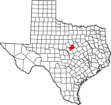
Fairy is an unincorporated community located in Hamilton County in Central Texas. Fairy is located in the northern part of the county at the junction of FM 219 and FM 1602.
History
Fairy was originally known as Martin's Gap. James Martin was a settler who took an oxcart through the mountain gap. The town was named for Fairy Fort, the daughter of Confederate Army captain Battle Fort, when the post office was established in 1884. Fairy had a cotton gin from 1900 to about 1936 and schools, churches, and businesses serving the greater ranching and farming community. In 1947, Fairy had a post office, three churches, three businesses, and 150 people. The post office closed in 1957, and the Fairy school district was consolidated with the Hamilton schools in 1967. In 1980, 1990, and 2000 the population was 31. A Baptist church, community center (formerly the Fairy Church of Christ), volunteer fire department, numerous dwellings, and a large historic cemetery remained at the Fairy community as of the early 2000s.
