Georgia State Route 51
| ||||
|---|---|---|---|---|
 | ||||
| Route information | ||||
| Maintained by GDOT | ||||
| Length: | 63.6 mi[1] (102.4 km) | |||
| Major junctions | ||||
| West end: |
| |||
|
| ||||
| East end: | Raindrop Circle on shore of Lake Hartwell | |||
| Location | ||||
| Counties: | Hall, Banks, Franklin, Hart | |||
| Highway system | ||||
| ||||

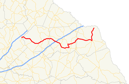
State Route 51 (SR 51) is a 63.6-mile-long (102.4 km) state highway that runs west-to-east through portions of Hall, Banks, Franklin, and Hart counties in the northeastern part of the U.S. state of Georgia. The route connects Lula with Lake Hartwell, via Hartwell.
Route description
SR 51 begins at an intersection with SR 52 in Lula, in Hall County. It travels northeast and curves to the southeast to cross into Banks County before it leaves town. It heads to the southeast and meets the northern terminus of SR 323 (John Morris Road) before entering Homer. There, it meets the northern terminus of SR 164 (Historic Homer Highway). At this intersection, the highway begins heading to the northeast taking over the Historic Homer Highway and enters downtown where it intersects Athens Street and Yonah Homer Road, the former of which is an old segment of SR 98. Later the road makes a slight curve to the southeast and then goes back to the northeast, crosses a bridge over the Hudson River, and then turns east off of the Historic Homer Highway onto Old Federal Road. Then, it intersects US 441/SR 15. Then, the route continues to the east, intersecting SR 63 (Martin Bridge Road) in Jewelville, just before entering Franklin County. It curves to the southeast and has an interchange with Interstate 85 (I-85) and an interchange with SR 59 southwest of Carnesville. It intersects SR 326 and SR 106 (Athens Road), before passing through Sandy Cross. There, it meets the northern terminus of SR 174 (Salem Road) and begins to curve to the east and meets the western terminus of SR 145 (Royston Road). The two routes head concurrent to the north-northwest for just over 1 mile (1.6 km), until SR 51 heads to the east-northeast. It intersects SR 327 before entering Canon. In town, it intersects SR 17 (Broad Street). The two routes head concurrent to the northeast, into Bowersville, where SR 51 splits off to the east-southeast. In Flat Shoals, to the west-northwest of Hartwell, the route begins a concurrency with SR 77 (Lavonia Highway). The two routes cross over part of Lake Hartwell, before entering Hartwell. In town, they intersect US 29/SR 8 (Athens Street). All four highways head concurrent to the east-southeast for two blocks. There, SR 51 departs to the north onto Chandler Street. It crosses backwaters of Lake Hartwell before ending at an intersection with Raindrop Circle along the shores of the lake.[1]
SR 51 is not part of the National Highway System, a system of roadways important to the nation's economy, defense, and mobility.[2]
Major intersections
| County | Location | mi[1] | km | Destinations | Notes |
|---|---|---|---|---|---|
| Hall | Lula | 0.0 | 0.0 | Western terminus | |
| Banks | | 7.5 | 12.1 | Northern terminus of SR 323 | |
| Homer | 12.0 | 19.3 | Northern terminus of SR 164 | ||
| Hudson River | 13.3 | 21.4 | Unnamed bridge | Crossing over the Hudson River | |
| | 14.9 | 24.0 | |||
| Jewelville | 19.1 | 30.7 | |||
| Franklin | | 24.7 | 39.8 | I-85, exit 160 | |
| | 25.0 | 40.2 | |||
| | 27.7 | 44.6 | |||
| | 30.1 | 48.4 | |||
| | 31.7 | 51.0 | Northern terminus of SR 174 | ||
| Middle Fork Broad River | 34.7 | 55.8 | Unnamed bridge | Crossing over the Middle Fork Broad River | |
| | 34.7 | 55.8 | Western end of SR 145 concurrency | ||
| | 37.1 | 59.7 | Eastern end of SR 145 concurrency | ||
| North Fork Broad River | 37.4 | 60.2 | Unnamed bridge | Crossing over the North Fork Broad River | |
| | 39.5 | 63.6 | |||
| Canon | 42.3 | 68.1 | Western end of SR 17 concurrency | ||
| Hart | Bowersville | 44.9 | 72.3 | Eastern end of SR 17 concurrency | |
| Flat Shoals | 51.8 | 83.4 | Western end of SR 77 concurrency | ||
| Lake Hartwell | 52.6 | 84.7 | Unnamed bridge | Crossing over the Lake Hartwell | |
| Hartwell | 53.7 | 86.4 | Western end of US 29/SR 8 concurrency | ||
| 53.8 | 86.6 | Eastern end of US 29/SR 8 & SR 77 concurrencies | |||
| 53.9 | 86.7 | Northbound lanes of US 29/SR 8/SR 77 on one-way pairs | |||
| Lake Hartwell | 55.6 | 89.5 | Unnamed bridge | Crossing over the Lake Hartwell | |
| Lake Hartwell | 56.0 | 90.1 | Unnamed bridge | Crossing over the Lake Hartwell | |
| | 63.6 | 102.4 | Raindrop Circle | Northern terminus | |
1.000 mi = 1.609 km; 1.000 km = 0.621 mi
| |||||
See also
-
.svg.png) Georgia (U.S. state) portal
Georgia (U.S. state) portal -
 U.S. Roads portal
References
- 1 2 3 Google (August 6, 2013). "Route of SR 51 (Lula to Lake Hartwell)" (Map). Google Maps. Google. Retrieved August 6, 2013.
Google (August 6, 2013). "Route of SR 51 (Lake Hartwell to Raindrop Circle)" (Map). Google Maps. Google. Retrieved August 6, 2013. - ↑ "National Highway System: Georgia" (PDF). United States Department of Transportation. October 1, 2012. Retrieved August 5, 2013.