Interstate 25 in New Mexico
| |||||||
|---|---|---|---|---|---|---|---|
_map.svg.png) | |||||||
| Route information | |||||||
| Maintained by NMDOT | |||||||
| Length: | 462.12 mi[1] (743.72 km) | ||||||
| Existed: | 1957[2] – present | ||||||
| Major junctions | |||||||
| South end: |
| ||||||
|
| |||||||
| North end: |
| ||||||
| Location | |||||||
| Counties: | Doña Ana, Sierra, Socorro, Valencia, Bernalillo, Sandoval, Santa Fe, San Miguel, Mora, Colfax | ||||||
| Highway system | |||||||
| |||||||

In the U.S. state of New Mexico, Interstate 25 (I-25) follows the north–south corridor through Albuquerque and Santa Fe. It replaced U.S. Route 85, which is no longer signed, but still exists in route logs sharing the I-25 alignment. I-25 starts in New Mexico at an interchange with I-10 in Las Cruces and extends roughly 460 miles before reaching Colorado. I-25 passes through principally rural land through central New Mexico and passes through or near the cities of Las Cruces, Truth or Consequences, Socorro, Belen, Albuquerque, Santa Fe, Las Vegas, and Raton.
Route description
Interstate 25 begins at Interstate 10's exit 144 in Las Cruces (elevation 4,000 feet (1,200 m)),[3] just south of the New Mexico State University campus. I-25 is concurrent with U.S. Route 85 at this point, and carries the US 85 concurrency for the remainder of its run in New Mexico. Immediately, the Interstate passes east of the New Mexico State campus, and the next three exits provide access to the city. The first exit is University Avenue, which provides access to NMSU. The final exit in Las Cruces is U.S. Route 70.[4] Upon exiting the city the speed limit increases by ten miles per hour to 75 mph. Before I-25 reaches Truth or Consequences and just south of Elephant Butte Reservoir State Park it crosses over to the west side of the Rio Grande.[5] From Las Cruces to Santa Fe I-25 follows the route of El Camino Real de Tierra Adentro.[6]
South of Albuquerque near Socorro it passes through the Bosque del Apache National Wildlife Refuge.[7] As I-25 nears Albuquerque, it has interchanges with roads such as U.S. Route 380 and a concurrency with U.S. Route 60.[8] State Road 6, the original U.S. Route 66, meets up with I-25 in Los Lunas.[9] Just to the south of Albuquerque I-25 enters Isleta Pueblo where it crosses back to the east side of the Rio Grande.[10]
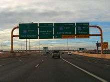
The speed limit on I-25 in Albuquerque is 65 mph (105 km/h), except for one 1.5 mile 55 mph (89 km/h) section between Gibson Boulevard and Central Avenue. Through Albuquerque I-25 is named the Pan American Freeway and there are frequent exits to city streets.[11][12]:248 A major interchange with Interstate 40 (which is styled as the Coronado Freeway in the city) is named the Big I.[12]:248[13] It was given an honorable mention by the United States Department of Transportation and the Federal Highway Administration for excellence in urban highway design in 2002.[14]
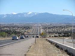
Leaving Albuquerque, the 75 mph (121 km/h) speed limit resumes as the freeway passes through Sandia Pueblo. After Bernalillo, I-25 passes through four more Indian Reservations (from south to north the Pueblos of Santa Ana, San Felipe, Kewa and Cochiti. I-25 turns to the northeast and away from the Rio Grande, alongside which it has run from its southern terminus, as it heads toward Santa Fe.[15] 11 mi (18 km) southwest of Santa Fe it climbs out of the Rio Grande Valley at a steep hill called La Bajada.[16]
Continuing 'northbound' at Santa Fe, I-25 heads southeast for approximately 45 miles (72 km) traveling through the Santa Fe National Forest and crossing Glorieta Pass (7,452 feet (2,271 m)).[17] It turns north again at Blanchard toward Las Vegas.[18] The highway maintains a north and northeast orientation as it leaves New Mexico traversing Raton Pass (7,798 feet (2,377 m)[19]) and enters Colorado. The speed limit through Raton Pass is 65 mph (105 km/h). From Santa Fe to Raton Pass I-25 approximates part of the route of the Santa Fe Trail.[20] I-25 is 462.124 miles long in New Mexico.[1]
Exit list
| County | Location | mi[21] | km | Exit | Destinations | Notes |
|---|---|---|---|---|---|---|
| Doña Ana | Las Cruces | 0.00 | 0.00 | Southern terminus of I-25; southern end of US 85 concurrency; I-10 exit 144 | ||
| — | Southbound exit and northbound entrance; I-10 exit 144 | |||||
| 1 | University Avenue | Access to New Mexico State University | ||||
| 3 | Lohman Avenue | |||||
| 7.4 | 11.9 | 6 | ||||
| 11.12 | 17.90 | 9 | ||||
| Radium Springs | 20.32 | 32.70 | 19 | Leasburg Dam State Park, Ft. Selden State Monument | ||
| | 34.22 | 55.07 | 32 | Upham | ||
| Rincon | 36.82 | 59.26 | 35 | |||
| Hatch | 42.659 | 68.653 | 41 | |||
| Sierra | Garfield | 52.03 | 83.73 | 51 | ||
| Caballo Lake | 60.89 | 97.99 | 59 | |||
| Caballo | 65.175 | 104.889 | 63 | |||
| | 72.89 | 117.31 | 71 | Las Palomas | ||
| Williamsburg | 76.389 | 122.936 | 75 | |||
| Truth or Consequences | 80.577 | 129.676 | 79 | |||
| 85.2 | 137.1 | 83 | ||||
| | 90.141 | 145.068 | 89 | |||
| | 92.831 | 149.397 | 92 | Elephant Butte Lake State Park | ||
| | 100.82 | 162.25 | 100 | |||
| Socorro | | 116.572 | 187.604 | 115 | ||
| | 125.881 | 202.586 | 124 | San Marcial, Bosque del Apache National Wildlife Refuge | ||
| San Antonio | 140.61 | 226.29 | 139 | |||
| Socorro | 149.225 | 240.154 | 147 | |||
| 151.728 | 244.183 | 150 | South end of US 60 overlap | |||
| Escondido | 153.62 | 247.23 | 152 | Escondida | ||
| Lemitar | 157.52 | 253.50 | 156 | |||
| | 164.32 | 264.45 | 163 | San Acacia | ||
| La Joya | 171.32 | 275.71 | 169 | Sevilleta National Wildlife Refuge | ||
| | 176.566 | 284.155 | 175 | North end of US 60 overlap | ||
| Valencia | Belen | 191.35 | 307.95 | 190 | ||
| 193.435 | 311.303 | 191 | Camino del Llano | |||
| | 197.56 | 317.94 | 195 | |||
| Los Lunas | 205.376 | 330.521 | 203 | |||
| Bernalillo | | 209 | ||||
| | 213.394 | 343.424 | 213 | |||
| Albuquerque | 217.18 | 349.52 | 215 | |||
| 221.768 | 356.901 | 220 | ||||
| 221 | Sunport Boulevard – Albuquerque International Sunport | |||||
| 222 | Gibson Boulevard – Albuquerque International Sunport, Kirtland AFB | Signed as exits 222A (east) and 222B (west) southbound | ||||
| 223 | Avenida Cesar Chavez | |||||
| 224A | Central Avenue, Lead Avenue, Coal Avenue | Northbound access via Oak Street, southbound via Locust Street | ||||
| 224B | Central Avenue, Dr. Martin Luther King, Jr. Avenue (MLK Avenue) | Northbound access via Oak Street, southbound via Locust Street | ||||
| 225 | Candelaria Road, Lomas Boulevard, Menaul Boulevard | |||||
| 227.225 | 365.683 | 226A-B | Signed as exits 226A (east) and 226B (west); I-40 exits 159B-C | |||
| 227 | Comanche Road, Griegos Road, Candelaria Road, Menaul Boulevard | |||||
| 228 | Montgomery Boulevard, Montaño Road | Montaño Road is west of I-25, Montgomery Blvd. is east of I-25. | ||||
| 229 | Jefferson Street | |||||
| 230 | San Mateo Boulevard, Osuna Road | |||||
| 231 | San Antonio Avenue, Ellison Road, Osuna Road | |||||
| 232 | ||||||
| 233 | ||||||
| Sandia Pueblo Nation | 234 | |||||
| Sandoval | Bernalillo | 240 | ||||
| 243.533 | 391.928 | 242 | Formerly New Mexico State Highway 44 | |||
| | 249.258 | 401.142 | 248 | |||
| | 253.736 | 408.349 | 252 | San Felipe Pueblo | ||
| | 258.916 | 416.685 | 257 | Budaghers | ||
| | 259 | |||||
| Santa Fe | | 266.21 | 428.42 | 264 | ||
| | 268.73 | 432.48 | 267 | Waldo Canyon Road | ||
| La Cienega | 273.13 | 439.56 | 271 | |||
| | 277.07 | 445.90 | 276 | |||
| Santa Fe | 278.91 | 448.86 | 278 | Signed as exits 278A (south) and 278B (north) southbound | ||
| 282 | South end of US 84/US 285 overlap; signed as exits 282A (Frontage Road) and 282B (US 84/US 285) southbound | |||||
| 284 | ||||||
| | 291.773 | 469.563 | 290 | North end of US 285 overlap | ||
| | 295.596 | 475.716 | 294 | Canoncito at Apache Canyon | ||
| | 298.47 | 480.34 | 297 | Valencia | ||
| | 300.4 | 483.4 | 299 | |||
| San Miguel | | 309.1 | 497.4 | 307 | ||
| Sands | 321.72 | 517.76 | 319 | San Jose, San Juan | ||
| | 324.59 | 522.38 | 323 | |||
| | 331.52 | 533.53 | 330 | Bernal | ||
| | 336.62 | 541.74 | 335 | Tecolote | ||
| | 341.321 | 549.303 | 339 | North end of US 84 overlap | ||
| Las Vegas | 345.339 | 555.769 | 343 | |||
| 345 | ||||||
| 349.595 | 562.619 | 347 | ||||
| | 353.53 | 568.95 | 352 | Las Vegas Municipal Airport | ||
| | 357.73 | 575.71 | 356 | Onava | ||
| | 362.93 | 584.08 | 361 | Warren Ranch Road | ||
| Mora | Watrous | 365.64 | 588.44 | 364 | ||
| 368.43 | 592.93 | 366 | ||||
| Wagon Mound | 389.496 | 626.833 | 387 | |||
| | 394.89 | 635.51 | 393 | Levy | ||
| Colfax | | 406.19 | 653.70 | 404 | ||
| Springer | 413.69 | 665.77 | 412 | |||
| 416.26 | 669.91 | 414 | ||||
| | 420.43 | 676.62 | 419 | |||
| Maxwell | 427.611 | 688.173 | 426 | |||
| | 436.76 | 702.90 | 435 | Tinaja | ||
| | 448.423 | 721.667 | 446 | South end of US 64 overlap | ||
| Raton | 451.675 | 726.900 | 450 | North end of US 64 overlap | ||
| 453.19 | 729.34 | 451 | South end of US 87 overlap | |||
| 454.29 | 731.11 | 452 | ||||
| 456.213 | 734.204 | 454 | ||||
| New Mexico–Colorado line | 462.124 | 743.716 | 460 | Truck weigh station | First southbound exit in New Mexico; exit not signed northbound | |
| Continuation into Colorado | ||||||
1.000 mi = 1.609 km; 1.000 km = 0.621 mi
| ||||||
References
- 1 2 "Interstate Highways" (PDF). New Mexico Department of Transportation. Retrieved 2011-06-16.
- ↑ Official Route Numbering for the National System of Interstate and Defense Highways (Map). American Association of State Highway Officials. August 14, 1957. Retrieved June 16, 2011.
- ↑ Google (2007-07-07). "I-25 at I-10" (Map). Google Maps. Google. Retrieved 2007-07-07.
- ↑ Google (2007-07-07). "I-25 in Las Cruces" (Map). Google Maps. Google. Retrieved 2007-07-07.
- ↑ Google (2007-07-07). "I-25 parallels Elephant Butte Reservoir State Park" (Map). Google Maps. Google. Retrieved 2007-07-07.
- ↑ Wilkerson, Lyn (2003). American Trails Revisited: Following in the Footsteps of the Western Pioneers. Lincoln, NE: ¡Universe, Inc. p. 154. ISBN 0595282628. Retrieved 13 February 2013.
- ↑ Google (2013-04-13). "I-25 near Socorro" (Map). Google Maps. Google. Retrieved 2013-04-13.
- ↑ Google (2007-07-07). "I-25 near Albuquerque" (Map). Google Maps. Google. Retrieved 2007-07-07.
- ↑ Google (2007-07-07). "I-25 at SR 6" (Map). Google Maps. Google. Retrieved 2007-07-07.
- ↑ Google (2013-04-13). "I-25 near Isleta" (Map). Google Maps. Google. Retrieved 2013-04-13.
- ↑ Google (2007-07-07). "I-25 exits in Albuquerque" (Map). Google Maps. Google. Retrieved 2007-07-07.
- 1 2 Bryan, Howard (1989). Albuquerque Remembered. Albuquerque: University of New Mexico Press. ISBN 0826337821. OCLC 62109913. Retrieved 13 February 2013.
- ↑ Google (2007-07-07). "I-25 at I-40" (Map). Google Maps. Google. Retrieved 2007-07-07.
- ↑ "I-25/I-40 System-to-System Interchange". Excellence in highway design. Federal Highway Administration. 2002. Retrieved 2007-07-07.
- ↑ Google (2007-07-07). "I-25 nearing Santa Fe" (Map). Google Maps. Google. Retrieved 2007-07-07.
- ↑ Julyan, Robert (1998). The Place Names of New Mexico (2nd ed.). University of New Mexico Press. Retrieved 13 February 2013.
La Bajada hill is located 11 miles southwest of Santa Fe. From 1598, when Spanish colonists trudged beside lumbering oxcarts, to the early 20th century, when American tourists drove Model A automobiles, the steep and abrupt escarpment of La Bajada Hill was a notorious landmark on the road between Santa Fe and Albuquerque. The old route up La Bajada Hill was barely 1.5 miles long, but it traversed tough volcanic rock; in the 20th century it included 23 hairpin turns and was the scene of countless frustrations and mishaps, from overturned wagons to boiling radiators. Residents of the village of La Bajada (see entry) at the hill's base named a spot on the hill Florida because a truck carrying oranges overturned there. In 1932, a new route up the escarpment was laid out, followed today by I-25, and the original route, 5 mi N and W, fell into disuse, though a few drivers still attempt it to test their vehicles' toughness. The name La Bajada now is gradually being transferred to the new route.
- ↑ "Glorieta Pass". Santa Fe Trail National Scenic Byway. The Santa Fe Trail Scenic Byway Profile. Retrieved 13 February 2013.
- ↑ Google (2007-07-07). "I-25 near Las Vegas" (Map). Google Maps. Google. Retrieved 2007-07-07.
- ↑ "Raton Pass". National Historic Landmark summary listing. National Park Service. Retrieved 2007-10-13.
- ↑ Glassman, Steve (2008). It Happened on the Santa Fe Trail. Morris Publishing. p. ix. ISBN 0762745738. Retrieved 13 February 2013.
- ↑ http://dot.state.nm.us/content/dam/nmdot/Travel_conditions/maps/SW_V9_2_ELEV_RB_2007.pdf
| Previous state: Terminus |
New Mexico | Next state: Colorado |
| Wikimedia Commons has media related to Interstate 25 in New Mexico. |