Katsurao, Fukushima
| Katsurao 葛尾村 | |||
|---|---|---|---|
| Village | |||
| |||
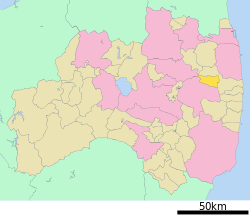
 Location of Katsurao in Fukushima Prefecture | |||
 Katsurao
| |||
| Coordinates: 37°30′13″N 140°45′52″E / 37.50361°N 140.76444°ECoordinates: 37°30′13″N 140°45′52″E / 37.50361°N 140.76444°E | |||
| Country | Japan | ||
| Region | Tōhoku | ||
| Prefecture | Fukushima | ||
| District | Futaba | ||
| Area | |||
| • Total | 84.23 km2 (32.52 sq mi) | ||
| Population (December 2014) | |||
| • Total | 1,451 | ||
| • Density | 17.2/km2 (45/sq mi) | ||
| Time zone | Japan Standard Time (UTC+9) | ||
| City symbols | |||
| • Tree | Pinus densiflora | ||
| • Flower | Azalea | ||
| • Bird | Green pheasant | ||
| Phone number | 0247-61-2850 | ||
| Address | Ochiai 16, Katsurao-mura, Futaba-gun, Fukushima-ken 979-1602 | ||
| Website | Official website | ||
Katsurao (葛尾村 Katsurao-mura) is a village located in Futaba District, Fukushima Prefecture, Japan. As of December 2014, the village had a nominal registered population of 1,451 and a population density of 17.2 persons per km2. The total area was 84.93 square kilometres (32.79 sq mi).[1]
Geography
Katsurao is located in the Abukuma Plateau of central Fukushima with a mean altitude of over 500 meters.
Surrounding municipalities
- Fukushima Prefecture
History
The area of present-day Katsurao was part of Mutsu Province, and was included in the tenryo holdings of the Tokugawa shogunate during Edo period Japan. After the Meiji restoration, on April 1, 1889, the village of Katsurao was created within Futaba District, Fukushima.
2011 Fukushima Daiichi nuclear disaster
Although Katsurao escaped significant damage from the 2011 Tōhoku earthquake and tsunami, it was located downwind of the Fukushima Daiichi Nuclear Power Plant. Although outside the nominal 20-kilometer exclusion zone, as a result of wind patterns following the Fukushima Daiichi nuclear disaster, the entire population of the village was evacuated by government order by May 2011. In March 2013, the government divided the village into three zones, with the majority of the village area cleared for unrestricted return of its inhabitants by spring of 2014, a smaller area cleared for daylight return only, and a larger area in which the existing restrictions against entry would be maintained until at least 2017. [2] However, in March 2014, the government postponed lifting of the restrictions on return for a year due to remaining high levels of radiation.[3][4] On June 12, 2016, the evacuation order was lifted for 90% of the village.[5]
Economy
The economy of Katsuro was formerly heavily dependent on agriculture.
Education
Katsurao had one middle school and one elementary school in March 2011.
Transportation
Railway
- Katsurao is not served by any train stations.
Highway
References
| Wikimedia Commons has media related to Katsurao, Fukushima. |
- ↑ "Home Page" (in Japanese). Katsurao Village. Retrieved 6 February 2015.
- ↑ "Katsurao, Tomioka, Namie to be reclassified into 3 zones", Fukushima Minpo News, March 8, 2013.
- ↑ "Lifting of Fukushima villages’ evacuation advisory to be delayed ", The Japan Times, March 1, 2014.
- ↑ Myoraku, Asao "Fukushima villages face 1-year delay in lifting of evacuation orders", The Asahi Shimbun, February 28, 2014.
- ↑ "Evacuation lifted for Fukushima village; only 10% preparing return:The Asahi Shimbun". The Asahi Shimbun. Retrieved 2016-06-13.
