| Route[8] |
Name(s)[1] |
Length[1][12] |
Western/Southern Terminus[1] |
Eastern/Northern Terminus[1] |
Communities |
Comments |
|---|
| km |
mi |
| 7000200000000000000♠ |
Simcoe Street |
20.7 |
12.9 |
7002202000000000000♠High Park Road |
7000900000000000000♠ City Road 9 (Woodville Road) City Road 9 (Woodville Road) |
Seagrave, Sonya, Manilla |
Signed and maintained by both the City of Kawartha Lakes[8][13] and the Regional Municipality of Durham[14] north of Seagrave |
7000300000000000000♠
 | Kawartha Lakes Road 3 | |
Hartley Road |
0.9 |
0.56 |
7001480000000000000♠ City Road 48 (Portage Road) City Road 48 (Portage Road) |
7002203000000000000♠Robinson Avenue |
Victoria Road |
Shortest city road in Kawartha Lakes |
| 7000400000000000000♠ |
Little Britain Road, Angeline Street, Thunder Bridge Road |
32.1 |
19.9 |
7000200000000000000♠ City Road 2 (Simcoe Street) City Road 2 (Simcoe Street) |
7001180000000000000♠ City Road 18 (Elm Tree Road) City Road 18 (Elm Tree Road) |
Little Britain, Lindsay |
|
7000500000000000000♠
 | Kawartha Lakes Road 5 | |
Janetville Road |
7.3 |
4.5 |
7000108000000000000♠Highway 7A |
7001570000000000000♠ City Road 57 (Golf Course Road) City Road 57 (Golf Course Road) |
Janetville |
|
| 7000600000000000000♠ |
Eldon Road, Kirkfield Road,
Sadowa Road, Chisholm Trail, Black River Road |
78.8 |
49.0 |
7001280000000000000♠ City Road 28 (Ramsey Road) City Road 28 (Ramsey Road) |
7001520000000000000♠ County Road 52 (Coopers Falls Road) County Road 52 (Coopers Falls Road) |
Little Britain, Oakwood, Kirkfield, Sebright, Sadowa |
Prior to 1998, a segment was designated as  Highway 503;[10][11] concurrent with City Road 9 for 0.5 km (0.31 mi)[note 4] Highway 503;[10][11] concurrent with City Road 9 for 0.5 km (0.31 mi)[note 4] |
| 7000700000000000000♠ |
Sturgeon Road, Thurstonia Road |
22.4 |
13.9 |
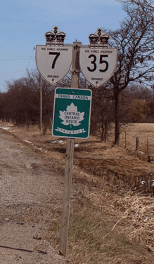
7000107000000000000♠ Highway 7 (King Street) Highway 7 (King Street) |
7002207000000000000♠Hazel Street (Sturgeon Lake) |
Omemee, Downeyville, Dunsford |
Ends at Sturgeon Lake, turning west and becoming Hazel Street |
| 7000800000000000000♠ |
Glenarm Road, Victoria Road, Helen Street, Colborne Street, North Street, Duke Street |
46.0 |
28.6 |
7000200000000000000♠ City Road 2 (Simcoe Street) |
7001360000000000000♠ City Road 36 (East Street North) City Road 36 (East Street North) |
Argyle, Glenarm, Fenelon Falls, Bobcaygeon |
Previously numbered as Highway 35A between Highway 35 and former Highway 121, prior to 1998;[10][11] continues westward as  Regional Road 15;[1] concurrent with City Road 8 for 1.9 km (1.2 mi)[note 4] Regional Road 15;[1] concurrent with City Road 8 for 1.9 km (1.2 mi)[note 4] |
7000900000000000000♠
| Kawartha Lakes Road 9 | |
Woodville Road, King Street, Cambray Road |
22.1 |
13.7 |
7000200000000000000♠ City Road 2 (Simcoe Street) |
7000135000000000000♠ Highway 35 Highway 35 |
Woodville, Cambray |
Concurrent with City Road 6 for 0.5 km (0.31 mi);[note 4] concurrent with City Road 46 for 0.3 km (0.19 mi)[note 4] |
7001100000000000000♠
 | Kawartha Lakes Road 10 | |
Emily Park Road, Centreline Road |
15.5 |
9.6 |
7002210000000000000♠Hayes Line |
7001170000000000000♠ City Road 17 (Pigeon Lake Road) City Road 17 (Pigeon Lake Road) |
Emily |
Continues southward as County Road 10; concurrent with City Road 17 for 1.1 km (0.68 mi)[note 4] |
| 7001110000000000000♠ |
Pleasant Point Road |
2.8 |
1.7 |
7001360000000000000♠ City Road 36 |
7002211000000000000♠Sturgeon Lake |
Pleasant Point |
Ends at a dead end at the shores of Sturgeon Lake |
7001120000000000000♠
 | Kawartha Lakes Road 12 | |
Pontypool Road |
9.3 |
5.8 |
7000135000000000000♠ Highway 35 |
7002212000000000000♠Glamorgan Road |
Pontypool |
Continues eastward as County Road 21[1] |
7001140000000000000♠
 | Kawartha Lakes Road 14 | |
Peace Road, Yankee Line |
11.3 |
7.0 |
7000700000000000000♠ City Road 7 (Sturgeon Road) City Road 7 (Sturgeon Road) |
7002214000000000000♠Boundary Road |
Emily |
Continues eastward as County Road 14[1] |
7001150000000000000♠
 | Kawartha Lakes Road 15 | |
Lindsay Street |
3.3 |
2.1 |
7000100000000000000♠ Highway 7 / Highway 35 |
7001170000000000000♠ City Road 17 (Wellington Street, Queen Street) |
Lindsay |
Lindsay Street is the east-west divider for Lindsay, so many streets (including its terminus) are named differently on either side[1] |
7001160000000000000♠
 | Kawartha Lakes Road 16 | |
Ogemah Road, Cottage Road |
4.3 |
2.7 |
7002216000000000000♠Washburn Island Road |
7001280000000000000♠ City Road 28 (Ramsey Road) |
|
|
| 7001170000000000000♠ |
Colborne Street, William Street, Wellington Street, Lindsay Street, Verulam Street, Pigeon Lake Road |
36.1 |
22.4 |
7000135000000000000♠ Highway 35 |
7001360000000000000♠ City Road 36 |
Lindsay |
Concurrent with City Road 10 for 1.1 km (0.68 mi);[note 4] formerly Highway 36B within Lindsay[11] |
7001180000000000000♠
| Kawartha Lakes Road 18 | |
Elm Tree Road |
20.9 |
13.0 |
7001280000000000000♠ City Road 28 (Valentia Road) |
7000900000000000000♠ City Road 9 (Cambray Road) |
Valentia, Cambray |
Shares its southern/western terminus with the southern/eastern terminus of City Road 28[1] |
7001190000000000000♠
 | Kawartha Lakes Road 19 | |
Mary Street |
1.4 |
0.87 |
7000400000000000000♠ City Road 4 (Angeline Street South) City Road 4 (Angeline Street South) |
7001150000000000000♠ City Road 15 (Lindsay Street South) |
Lindsay |
|
7001200000000000000♠
 | Kawartha Lakes Road 20 | |
Boundary Road |
7.6 |
4.7 |
7002220000000000000♠Darlington–Manvers Townline Road |
7000199000000000000♠ Highway 115 Highway 115 |
|
Follows the southern boundary of Kawartha Lakes; continues westward as  Regional Road 20[1] Regional Road 20[1] |
7001210000000000000♠
 | Kawartha Lakes Road 21 | |
Killarney Bay Road |
11.0 |
6.8 |
7000135000000000000♠ Highway 35 |
7000800000000000000♠ City Road 8 (Glenarm Road) City Road 8 (Glenarm Road) |
|
|
7001220000000000000♠
 | Kawartha Lakes Road 22 | |
Francis Street East |
2.3 |
1.4 |
7002222000000000000♠River Drive |
7000800000000000000♠ City Road 8
 City Road 121 (Colborne Street) City Road 121 (Colborne Street) |
Fenelon Falls |
|
| 7001240000000000000♠ |
Park Street, King Street |
13.0 |
8.1 |
7001360000000000000♠ City Road 36 |
7001360000000000000♠ City Road 36 (East Street South) |
Dunsford, Bobcaygeon |
|
7001250000000000000♠
 | Kawartha Lakes Road 25 | |
Sturgeon Point Road |
7.8 |
4.8 |
7002225000000000000♠Irene Avenue |
7000800000000000000♠ City Road 8 |
Sturgeon Point |
|
7001260000000000000♠
 | Kawartha Lakes Road 26 | |
Frank Hill Road |
6.3 |
3.9 |
7000107000000000000♠ Highway 7 |
7001140000000000000♠ City Road 14 (Yankee Line) |
Fowlers Corners |
|
7001280000000000000♠
| Kawartha Lakes Road 28 | |
Ramsey Road, Valentia Road |
13.6 |
8.5 |
7000200000000000000♠ City Road 2 (Simcoe Street) |
7001180000000000000♠ City Road 18 (Elm Tree Road) |
Valentia |
City Road 28 shares its southern/eastern terminus with the southern/western terminus of City Road 18[1] |
7001300000000000000♠
 | Kawartha Lakes Road 30 | |
Blythe Shore Road |
6.0 |
3.7 |
7001250000000000000♠ City Road 25 (Sturgeon Point Road) |
7000800000000000000♠ City Road 8 |
|
|
7001310000000000000♠
 | Kawartha Lakes Road 31 | |
Mount Horeb Road |
11.4 |
7.1 |
7000135000000000000♠ Highway 35 |
7000107000000000000♠ Highway 7 |
Omemee |
|
7001320000000000000♠
 | Kawartha Lakes Road 32 | |
Porter Road |
7.7 |
4.8 |
7000199000000000000♠ Highway 115 |
7000108000000000000♠Highway 7A |
Manvers |
|
7001330000000000000♠
 | Kawartha Lakes Road 33 | |
Centennial Park Road |
6.7 |
4.2 |
7001480000000000000♠ City Road 48 (Portage Road) |
7000600000000000000♠ City Road 6 (Kirkfield Road) City Road 6 (Kirkfield Road) |
Rohallion |
|
7001340000000000000♠
 | Kawartha Lakes Road 34 | |
Long Beach Road, Cameron Road |
12.3 |
7.6 |
7002234000000000000♠Manor Road (Sturgeon Lake) |
7000800000000000000♠ City Road 8 (Glenarm Road) |
Long Beach, Cameron |
|
| 7001350000000000000♠ |
Fennel Road, Victoria Road |
30.5 |
19.0 |
7000800000000000000♠ City Road 8 (Glenarm Road) |
7001450000000000000♠ City Road 45 (Monck Road) City Road 45 (Monck Road) |
Glenarm, Victoria Road, Uphill |
The northern 19.1 km (11.9 mi) were designated as  Highway 505, prior to 1997[10][11] Highway 505, prior to 1997[10][11] |
| 7001360000000000000♠ |
Verulam Road, East Street |
36.2 |
22.5 |
7000107000000000000♠ Highway 7 |
7001490000000000000♠ City Road 49 (Main Street) City Road 49 (Main Street) |
Lindsay, Dunsford, Bobcaygeon |
Formerly  Highway 36, prior to 1997;[10][11] continues eastward as County Road 36[1] Highway 36, prior to 1997;[10][11] continues eastward as County Road 36[1] |
7001370000000000000♠
 | Kawartha Lakes Road 37 | |
Bury's Green Road |
11.2 |
7.0 |
7002121000000000000♠ City Road 121 |
7001490000000000000♠ City Road 49 |
Fell Station, Bury's Green |
Formerly Victoria County Road 36, prior to 1998;[11] renumbered Victoria County Road 37 by 1999[10] |
7001380000000000000♠
 | Kawartha Lakes Road 38 | |
Ski Hill Road |
13.6 |
8.5 |
7000108000000000000♠Highway 7A |
7000107000000000000♠ Highway 7 (King Street West) |
Bethany, Franklin, Omemee |
|
7001410000000000000♠
 | Kawartha Lakes Road 41 | |
Bexley–Laxton Township Line |
12.1 |
7.5 |
7001480000000000000♠ City Road 48 (Portage Road) |
7001450000000000000♠ City Road 45 (Monck Road) |
Corsons, Bexley |
|
7001420000000000000♠
 | Kawartha Lakes Road 42 | |
Base Line Road |
11.4 |
7.1 |
7000135000000000000♠ Highway 35 (Main Street) |
7001450000000000000♠ City Road 45 (Monck Road) |
Coboconk, Dongola |
|
7001430000000000000♠
 | Kawartha Lakes Road 43 | |
6th Concession Road, Northline Road, 7th Concession Road |
9.6 |
6.0 |
7000135000000000000♠ Highway 35 |
7001440000000000000♠ City Road 44 (Burnt River Road) City Road 44 (Burnt River Road) |
Coboconk, Burnt River |
|
7001440000000000000♠
| Kawartha Lakes Road 44 | |
Burnt River Road, Hillside Drive |
3.9 |
2.4 |
7002121000000000000♠ City Road 121 |
7002121000000000000♠ City Road 121 |
Burnt River |
A short bypass of City Road 121 through the village of Burnt River[1] |
| 7001450000000000000♠ |
Monck Road |
50.0 |
31.1 |
7000600000000000000♠ City Road 6 (Kirkfield Road) |
7002245000000000000♠Bobcaygeon Road |
Sebright, Ragged Rapids, Uphill, Norland, Dongola, Kinmount |
Formerly Highway 503, prior to 1997;[10][11] continues westward as County Road 45, eastward as County Road 503[1] |
| 7001460000000000000♠ |
Agnes Street, King Street, Nappadale Street |
25.7 |
16.0 |
7000107000000000000♠ Highway 7 |
7001480000000000000♠ City Road 48 (Portage Road) |
Woodville, Argyle, Bolsover |
Formerly  Highway 46, prior to 1997;[10][11] concurrent with City Road 9 for 0.3 km (0.19 mi)[note 4] Highway 46, prior to 1997;[10][11] concurrent with City Road 9 for 0.3 km (0.19 mi)[note 4] |
7001470000000000000♠
 | Kawartha Lakes Road 47 | |
Mara–Carden Boundary Road, Brechin Road |
8.2 |
5.1 |
7002247000000000000♠Concession Road |
7000600000000000000♠ City Road 6 (Kirkfield Road) |
|
Continues westward as County Road 47[1] |
| 7001480000000000000♠ |
Portage Road |
29.2 |
18.1 |
7002248000000000000♠Eldon–Thorah Townline Road |
7000135000000000000♠ Highway 35 (Main Street) |
Bolsover, Kirkfield, Victoria Road, Corsons, Coboconk |
Formerly  Highway 48, prior to 1997;[10][11] Highway 48, prior to 1997;[10][11]
Continues westward as  Regional Road 48[1] Regional Road 48[1] |
| 7001490000000000000♠ |
East Street North |
18.0 |
11.2 |
7001360000000000000♠ City Road 36 (Main Street) |
7002121000000000000♠ City Road 121 |
Bobcaygeon |
Formerly Highway 649, prior to 1997[10][11] |
7001570000000000000♠
| Kawartha Lakes Road 57 | |
Golf Course Road |
10.2 |
6.3 |
7002257000000000000♠Durham–Kawartha Lakes boundary |
7000135000000000000♠ Highway 35 |
Janetville |
Continues westward as  Regional Road 57[1] Regional Road 57[1] |
| 7002121000000000000♠ |
Lindsay Street, Colborne Street, Short Street, Snowdon Road |
42.0 |
26.1 |
7000135000000000000♠ Highway 35 |
7002299000000000000♠Boundary Road |
Fenelon Falls, Burnt River, Kinmount |
Formerly Highway 121, prior to 1998;[10][11] continues northward as County Road 121;[1] concurrent with City Road 8 for 1.9 km (1.2 mi)[note 4] |

 Canada Roads portal