La Frontera, Santa Cruz de Tenerife
| Frontera | |||
|---|---|---|---|
| Municipality | |||
| |||
 | |||
| Coordinates: 27°45′0″N 18°1′0″W / 27.75000°N 18.01667°WCoordinates: 27°45′0″N 18°1′0″W / 27.75000°N 18.01667°W | |||
| Country |
| ||
| Autonomous community |
| ||
| Province |
| ||
| Island |
| ||
| Area[1] | |||
| • Total | 84.20 km2 (32.51 sq mi) | ||
| Elevation[1] | 300 m (1,000 ft) | ||
| Population (2009)[2] | |||
| • Total | 4,009 | ||
| • Density | 48/km2 (120/sq mi) | ||
| Postal code | E-38911 | ||
| Climate | BSh | ||
| Website | http://www.aytofrontera.org/ | ||


La Frontera (Spanish for "the border") is a municipality in the northwestern part of the island El Hierro, Santa Cruz de Tenerife, Canary Islands, Spain. In 2007, the southern part of the territory of La Frontera was split off to form the new municipality of El Pinar.
Sites of interest
- Punta de la Orchilla - a lighthouse situated in the west of the municipality. The lighthouse was first constructed to represent the old meridian. It used to mark the meridian line or the 0 degree-line at the lighthouse which was put by the French in 1634. Many 16th and 17th century maps had the prime meridian at Punta de la Orchilla. In 1884 the International Meridian Conference agreed to use the meridian of Greenwich as the standard prime meridian. Before the meridian change, El Hierro was known as Isla del Meridiano (Meridian Island).
- La Dehesa - here is the hermitage of the Virgen de los Reyes, patron saint of the island of El Hierro
Historical population
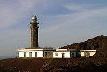
Lighthouse of Orchilla
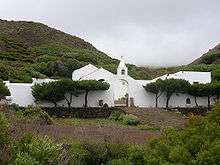
Virgen de los Reyes hermitage

Phoenicean Juniper (Juniperus phoenicea) at El Sabinar, El Hierro, Canary Islands (Spain)

Mirador de la Peña, El Hierro
| Year | Population |
|---|---|
| 1991 | 3,612 |
| 1996 | 4,409 |
| 2001 | 4,455 |
| 2002 | 5,359 |
| 2003 | 5,435 |
| 2004 | 5,231 |
| 2013 | 4,058 |
See also
References
- 1 2 "SUPERFICIE, PERÍMETRO Y ALTITUD DE LOS MUNICIPIOS DE CANARIAS." (in Spanish). Instituto Canario de Estadística (ISTAC).
- ↑ "Población en Canarias. El Hierro. 1-1-2009." (in Spanish). Instituto Canario de Estadística (ISTAC).
External links
| Wikimedia Commons has media related to La Frontera, El Hierro. |
 |
Atlantic Ocean | | ||
| Atlantic Ocean | |
Valverde | ||
| ||||
| | ||||
| El Pinar |
Municipalities of El Hierro | ||
|---|---|---|
This article is issued from Wikipedia - version of the 9/6/2016. The text is available under the Creative Commons Attribution/Share Alike but additional terms may apply for the media files.