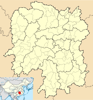
Lianyuan
| Lianyuan 涟源市 | |
|---|---|
| County-level city | |
 Lianyuan Location in Hunan | |
| Coordinates: 27°41′31″N 111°39′50″E / 27.692°N 111.664°ECoordinates: 27°41′31″N 111°39′50″E / 27.692°N 111.664°E[1] | |
| Country | People's Republic of China |
| Province | Hunan |
| Prefecture-level city | Loudi |
| Area[2] | |
| • Total | 1,894.93 km2 (731.64 sq mi) |
| Population (2010)[3] | |
| • Total | 995,712 |
| • Density | 530/km2 (1,400/sq mi) |
| Time zone | China Standard (UTC+8) |
| Postal code | 4171XX |
| Website |
lianyuan |
Lianyuan (simplified Chinese: 涟源; traditional Chinese: 漣源; pinyin: Liányuán) is a county-level city under the administration of Loudi, Hunan province, China. According to the 2010 Census, Lianyuan has a population of 995,712 inhabitants.[4]
Subdivisions
The county-level city of Lianyuan is divided in one subdistrict and several towns. The information here presented uses data from 2010 national census.
| English Name | Chinese Name | Area | Population | Density |
|---|---|---|---|---|
| Lantian Subdistrict | 蓝田街道 | 23.2 | 81,880 | 3,529 |
| Liumutang Town | 六亩塘镇 | 69.8 | 57,951 | 830 |
| Shimashan Town | 石马山镇 | 117.7 | 68,879 | 585 |
| Anping Town | 安平镇 | 91.2 | 40,867 | 448 |
| Meijiang Town | 湄江镇 | 118.6 | 45,212 | 381 |
| Fukou Town | 伏口镇 | 199.7 | 53,244 | 267 |
| Qiaotouhe Town | 桥头河镇 | 132.5 | 96,279 | 727 |
| Qixingjie Town | 七星街镇 | 156.9 | 68,681 | 438 |
| Yangshi Town | 杨市镇 | 119.5 | 70,205 | 587 |
| Fengping Town | 枫坪镇 | 41.6 | 22,532 | 542 |
| Doulishan Town | 斗笠山镇 | 73.9 | 47,803 | 647 |
| Shuidongdi Town | 水洞底镇 | 82.0 | 40,943 | 499 |
| Baima Town | 白马镇 | 90.1 | 35,784 | 397 |
| Maotang Town | 茅塘镇 | 82.9 | 22,568 | 272 |
| Hetang town | 荷塘镇 | 102.0 | 42,406 | 416 |
| Jinshi Town | 金石镇 | 110.8 | 50,791 | 458 |
| Longtang Town | 龙塘镇 | 102.5 | 64,513 | 629 |
| Dutoutang Town | 渡头塘镇 | 62.9 | 29,404 | 467 |
| Sanjia Town | 三甲镇 | 82.2 | 38,658 | 470 |
| Gutang Town | 古塘镇 | 52.0 | 17,112 | 329 |
Sites of interest
There is a twenty years old noodle restaurant in Lanxi Bridge.
Transportation
References
- ↑ Google (2014-07-02). "Lianyuan" (Map). Google Maps. Google. Retrieved 2014-07-02.
- ↑ Loudi City Land Use Plan (2006–20)/《娄底市土地利用总体规划(2006-2020年)》.(Chinese) Accessed 8 July 2014.
- ↑ 娄底市2010年第六次全国人口普查主要数据公报 (in Chinese). Loudi People's Government. Retrieved 9 July 2014.
- ↑ (Chinese) Lianyuan Government website. Data from the Sixth National Population Census of the People's Republic of China
External links
This article is issued from Wikipedia - version of the 10/28/2016. The text is available under the Creative Commons Attribution/Share Alike but additional terms may apply for the media files.