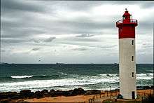
List of lighthouses in South Africa

Umhlanga Lighthouse
This is a list of lighthouses in South Africa. It contains currently active lights as well as decommissioned lights of historical importance.
Lighthouses
| Lighthouse | Located near | Coordinates | Year built |
Structure | Focal plane |
ALN | Notes |
|---|---|---|---|---|---|---|---|
| Bird Island | Bird Island[1] | 33°50′29.72″S 26°17′13.55″E / 33.8415889°S 26.2870972°E [1] | 1852-12-01, 1873-05-01[1] | 26 m masonry tower[1] | 30 m[1] | D6412[2] | The Doddington sank at the island in 1755.[1] |
| Bluff | Durban, KZN | 29°52′40″S 31°03′50″E / 29.87778°S 31.06389°E | 1867-01-12 | concrete tower | discontinued 1940-10-16, later demolished, coordinates are for the original iron tower [3][4][5] | ||
| Cape Agulhas | Cape Agulhas, WC | 34°49′08″S 20°00′33″E / 34.81889°S 20.00917°E | 1849-03-01 | 27 m tower | 31 m HW | D6370[6] | National monument [7] Provincial Heritage Site[8] |
| Cape Columbine | Paternoster, WC | 32°48′39″S 17°51′23″E / 32.81083°S 17.85639°E | 1936-10-01 | 15 m masonry tower | 80 m HW | D5810[9] | [10] |
| Cape Hangklip | 34°23′11.4″S 18°49′42.3″E / 34.386500°S 18.828417°E | 1960-11-25 | 22 m concrete tower | 34 m HW | D6280[11] | [3] | |
| Cape Hermes | Port St. Johns | 31°38′06″S 29°33′23″E / 31.63500°S 29.55639°E | 1903-05-01, 1904-10-16 | 13 m stone tower | 55 m | D6442[12] | [13] |
| Cape Infanta | 34°28′18.76″S 20°50′47.09″E / 34.4718778°S 20.8464139°E | 1979-03-15 | 15 m aluminium lattice tower | 53 m MSL | D6371[6] | [14] | |
| Cape Morgan | Morgan's Bay | 32°42′26″S 28°21′55″E / 32.70722°S 28.36528°E | 1964-02-05 | 12 m aluminium tower | 60 m | D6434[12] | [15] |
| Cape Point | Simon's Bay, WC | 34°21′24″S 18°30′00″E / 34.35667°S 18.50000°E | 1860-05-01, 1919-03-11 | 9 m masonry tower | 87 m HW | D6120[16] | [16][17] |
| Cape Recife | Algoa Bay, EC | 34°01′43.97″S 25°42′03.90″E / 34.0288806°S 25.7010833°E | 1851-04-01 | 24 m masonry tower | 28 m | D6390[2] | [18] |
| Cape Seal | Plettenberg Bay | 34°06′27.6″S 23°24′22.83″E / 34.107667°S 23.4063417°E | 1950-05-11 | 6 m tower | 146 m | D6384[19] | [14] |
| Cape St. Blaize | Mossel Bay | 34°11′09.45″S 22°09′25.14″E / 34.1859583°S 22.1569833°E | 1864-03-15 | 20.5 masonry tower | 73 m | D6378[19] | [20] |
| Cape St. Lucia | 28°30′54″S 32°24′00″E / 28.51500°S 32.40000°E | 1906-12-15, 1915 | 8 m cast iron tower | 113 m | D6484 | [21][22][23] | |
| Cape St. Martin | St Helena Bay, WC | 32°42′53″S 17°55′18.53″E / 32.71472°S 17.9218139°E | 1977-12-12 | 10 m aluminium lattice tower | 18 m | D5801[9] | [24] |
| Cape Vidal | Cape Vidal Forestry Reserve, KZN | 28°08′51.98″S 32°33′10.77″E / 28.1477722°S 32.5529917°E | 1985-07-08 | 23 m concrete tower | 64.5 m MSL | D6485[23] | painted yellow [25] |
| Castle Point | East London, CC | 1860-08-25 | wood | decommissioned 1895 [22][24] | |||
| Cooper Light | Brighton Beach, Durban, KZN | 29°56′05″S 31°00′15″E / 29.93472°S 31.00417°E | 1953-07-31 | 21 m concrete tower | 134 m | D6458[26] | [27] |
| Danger Point | 34°37′48.8″S 19°18′10.9″E / 34.630222°S 19.303028°E | 1895-01-01 | masonry tower | 45 m | D6320[6] | [28] | |
| Dassen Island | Dassen Island, WC | 33°25′54″S 18°05′22″E / 33.43167°S 18.08944°E | 1893-04-15 | 28 m iron tower | 47 m | D5860[29] | [30] |
| Deal Light | Papenkuils river mouth | 33°54′56″S 25°36′52″E / 33.91556°S 25.61444°E | 1973-11-01 | 22 m aluminium lattice tower | 26.9 m | D6400[2] | [1] |
| Doringbaai | Doringbaai | 31°49′00″S 18°14′00″E / 31.81667°S 18.23333°E[31] | 1963-04-02 | 21 m aluminum lattice tower | 36 m | D5734[31] | [32] |
| Durnford | Port Durnford Forestry Reserve | 28°55′00″S 31°55′30″E / 28.91667°S 31.92500°E | 1916-03-01 | 12 m steel tower | 49 m | D6482[33] | [34] |
| Great Fish | Port Alfred | 33°31′10″S 27°06′34″E / 33.51944°S 27.10944°E | 1898-07-01 | 9 m masonry tower | 85 m | D6416[12] | [35] |
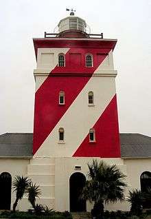
| Green Point | Green Point, WC | 33°54′04″S 18°24′02″E / 33.90111°S 18.40056°E | 1824-04-12 | 16 m masonry tower | 20 m HW | D5900[16] | [36][37] National monument and Provincial Heritage site[38] |
| Green Point | Umzinto, KZN | 30°14′56.1″S 30°46′38.9″E / 30.248917°S 30.777472°E | 1905 | 21 m cast iron tower | 86 m | D6454[26] | [39][40] |
| Groenriviermond | 30°51′53″S 17°34′49″E / 30.86472°S 17.58028°E | 1988-11-21 | 17.2 m concrete tower | 27.3 m | D5720[31] | [41] | |
| The Hill | Port Elizabeth, EC | 1861-06-01 | decommissioned 1973-10-31 [30] | ||||
| Hondeklipbaai | 30°18′30.7″S 17°16′17.8″E / 30.308528°S 17.271611°E | 1936-02-15, 1956-02-15 | 8 m steel tower | 29 m | D5704[31] | [32] | |
| Hood Point | East London, EC | 33°02′25.96″S 27°53′55.00″E / 33.0405444°S 27.8986111°E | 1895-06-04 | 19 m masonry tower | 55 m | D6420[12] | [42] |
| Ifafa Beach | 30°27′46.7″S 30°39′08.4″E / 30.462972°S 30.652333°E | 1980-02-04 | 23 m tower | 35.1 m MSL | D6452[26] | [43] | |
| Jesser Point | Sordwana Bay, KZN | 27°32′41.35″S 32°33′40.81″E / 27.5448194°S 32.5613361°E | 1986-04 | concrete tower | 61 m MSL | D6486[23] | [25] |
| M'bashe Point | 32°14′27.1″S 28°54′54″E / 32.240861°S 28.91500°E[12] | 1926-12-03 | 14 m lattice steel tower | 47 m | D6438[12] | [44] | |
| Milnerton | Milnerton, WC | 33°52′53.47″S 18°29′18.52″E / 33.8815194°S 18.4884778°E | 1960-03-10 | 21 m concrete tower | 28 m | D5910[45] | [46] |
| Mouille Point | 33°54′00″S 18°25′19″E / 33.90000°S 18.42194°E[47] | 1842-07-01, 1865 | Discontinued in 1908, demolished on or after 1921.[48] | ||||
| North Head | Saldanha Bay, WC | 33°03′00″S 17°54′42″E / 33.05000°S 17.91167°E | 1939-07-12, 1969-12-02 | 21 m aluminum tower | 33 m | D5830[9] | [31][49] |
| North Sand | 31°03′24″S 30°13′33″E / 31.05667°S 30.22583°E | 1968-07-17 | 21 m alumunium lattice tower | 38 m | D6448[12] | [50] | |
| Port Nolloth | Port Nolloth, NC | 29°14′58.36″S 16°52′08.48″E / 29.2495444°S 16.8690222°E | 1909 | 11 m aluminium lattice tower | 17 m | D5660[31] | [21] |
| Port Shepstone | Umzinkulu River mouth, KZN | 30°44′30.1″S 30°27′33.0″E / 30.741694°S 30.459167°E | 1895, ~1905 | 8 m cast iron tower | 24 m | D6450[12] | [35] |
| Quoin Point | 34°46′49.77″S 19°38′24.91″E / 34.7804917°S 19.6402528°E | 1955-03-02, 1990-10 | 21 m steel tower | 32 m | D6332[6] | [48] | |
| Richards Bay | Richards Bay, KZN | 28°46′30.3″S 32°07′41.1″E / 28.775083°S 32.128083°E | 1979-05-22 | 11 m concrete tower | 72 m MSL | D6483[23] | [34] |
| Robben Island | Robben Island, WC | 33°48′52.20″S 18°22′29.25″E / 33.8145000°S 18.3747917°E | 1865-01-01 | 18 m masonry tower | 47 m | D5870[29] | [51] |
| Roman Rock | Simon's Town, WC | 34°10′54″S 18°27′42″E / 34.18167°S 18.46167°E[16] | 1845,[52] 1861-09-16 | cast iron tower | 17 m HW | D6140[53] | [54] |
| Seal Point | Cape St. Francis, EC | 34°12′44.79″S 24°50′11.92″E / 34.2124417°S 24.8366444°E | 1878-07-04 | 27.75 m masonry tower | 36 m | D6386[19] | National monument [55] Provincial Heritage site[56] Construction started in 1875.[57] |
| Slangkop | Kommetjie | 34°08′54.59″S 18°19′11.89″E / 34.1484972°S 18.3199694°E | 1919-03-04 | 33 m iron tower | 41 m HW | D6110[16] | [58] |
| South Head | Saldanha Bay, WC | 33°06′19.44″S 17°57′18.01″E / 33.1054000°S 17.9550028°E | 1969-12-02 | 21 m aluminum tower | 34 m | D5831[9] | [49] |
| South Sand | EC | 31°19′38.10″S 29°57′41.11″E / 31.3272500°S 29.9614194°E | 1931-08-21 | 21 m steel tower | 82 m | D6446[12] | [50] |
| Tugela | 29°13′19.8″S 31°30′15.9″E / 29.222167°S 31.504417°E | 1972-11-22 | 21 m aluminium lattice tower | 36 m | D6481[33] | [43] | |
| Umhlanga Rocks | Durban, KZN | 29°43′41.57″S 31°05′18.20″E / 29.7282139°S 31.0883889°E | 1954-11-25 | 21 m concrete tower | 25 m | D6480[33] | [15] |
| Ystervarkpunt | 34°23′26″S 21°43′05″E / 34.39056°S 21.71806°E | 1964-08-04 | 21 m aluminium tower | 51 m | D6374[6] | [46] |
See also
- List of lighthouses and lightvessels
- Transnet National Ports Authority
- List of shipwrecks in South Africa
Gallery
 Seal Point Lighthouse
 Green Point Lighthouse, Cape Town
References
- Lighthouses of South Africa. Portnet. 1991. ISBN 0-620-16367-4.
- "Section 1 - List of Lights and Radio Signals". List of Lights, Fog Signals, Radio Navigational Aids and Radio Services (2008 ed.). South African Navy, Hydrographic Office. ISBN 9780958407175.
- Williams, Harold A. (1993). Southern lights: lighthouses of Southern Africa. Rivonia: William Waterman publications. ISBN 0-9583751-1-9.
- 1 2 3 4 5 6 7 Portnet (1991), p.26.
- 1 2 Portnet (1991), p.32.
- ↑ Ingram, Joseph Forsyth (1895). The colony of Natal; an official illustrated handbook and railway guide. J. Causton and sons. p. 82.
- ↑ Natal Almanac, Directory and Yearly Register. 1897. p. 531.
- ↑ Portnet (1991), p.19.
- ↑ "Cape LAgulhas Lighthouse Bredasdorp District". South African Heritage Resources Agency. Retrieved 7 December 2010.
- ↑ Portnet (1991), p.31.
- ↑ SA Navy (2008), p.18.
- ↑ Portnet (1991), p.37.
- 1 2 Portnet (1991), p.22.
- 1 2 Portnet (1991), p.14.
- ↑ Portnet (1991), p.33.
- ↑ Portnet (1991), p.27.
- ↑ Portnet (1991), p.23.
- 1 2 Portnet (1991), p.36.
- 1 2 Williams (1993), p.x.
- 1 2 Portnet (1991), p.30.
- 1 2 Portnet (1991), p.34.
- ↑ Portnet (1991), p.9.
- ↑ Portnet (1991), p.25.
- 1 2 Portnet (1991), p.42.
- 1 2 Portnet (1991), p.20.
- 1 2 Portnet (1991), p.40.
- 1 2 Portnet (1991), p.38.
- ↑ Williams (1993), p.1.
- ↑ Portnet (1991), p.17.
- ↑ "Green Point Lighthouse Cape Town". South African Heritage Resources Agency. Retrieved 7 December 2010.
- ↑ Williams (1993), p.93.
- ↑ Portnet (1991), p.11.
- ↑ Portnet (1991), p.21.
- ↑ Portnet (1991), p.39.
- 1 2 Portnet (1991), p.18.
- ↑ Portnet (1991), p.29.
- ↑ SA Navy (2008), p.16.
- 1 2 Portnet (1991), p.6.
- ↑ Lighthouses. Return to an Address of ... the House of Commons, dated 15 April 1850;- for, "Statement of what measures have been adopted respecting the erection, management and superintendence of lighthouses in the British colonies and possessions (in continuation of Parliamentary Paper, no.225, of Session 1849)" "and, Abstract of any Returns received from the colonies upon the subject since April 1849.". H. Hansard. 1850. Retrieved 8 December 2010.
- 1 2 Portnet (1991), p.24.
- 1 2 Portnet (1991), p.16.
- 1 2 Portnet (1991), p.28.
- ↑ Portnet (1991), p.41.
- ↑ Findlay, Alexander George (1879). A Description and List of the Lighthouses of the World. London. p. 136. Retrieved 7 December 2010.
- ↑ SA Navy (2008), p.27.
- ↑ Portnet (1991), p.43.
- ↑ Portnet (1991), p.15.
- ↑ "Seal Point Lighthouse Cape St Francis Humansdorp District". South African Heritage Resources Agency. Retrieved 7 December 2010.
- ↑ Sellick, W.S.J. (1904). Uitenhage, past and present : souvenir of the Centenary, 1804-1904. p. 125.
- ↑ Portnet (1991), p.35.
External links
- Baillie-Cooper, Simon (2006-07-23) Lighthouses of South Africa
- Lighthouse Map and Light Characteristics: Lighthouses, South Africa
| Wikimedia Commons has media related to Lighthouses in South Africa. |
This article is issued from Wikipedia - version of the 12/2/2016. The text is available under the Creative Commons Attribution/Share Alike but additional terms may apply for the media files.
_-_cropped.jpg)