List of villages in Niue

Villages of Niue

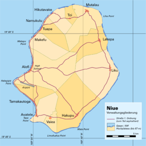
Administrative village boundaries
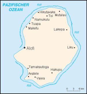
Niue is subdivided into 14 villages (municipalities). The capital, Alofi, consists of Alofi North and Alofi South. Each village has a village council that elects its chairman. The villages are at the same time electoral districts. Each village sends an assemblyman to the Parliament of Niue.[1]
The table lists the villages with population and area. These are the administrative subdivisions of Niue. Some of them include smaller settlements and hamlets.
The villages Alofi North and Alofi South together serve as the capital of Niue, Alofi (pop. 614). In the following table, the villages are listed in clockwise sequence.
| No. | Village | Population (Census 2001) | Area[2] km² | Pop. Density (km−2) |
|---|---|---|---|---|
| Motu (historical tribal area in the north) | ||||
| 1 | Makefu | 87 | 17.13 | 5.1 |
| 2 | Tuapa | 129 | 12.54 | 10.3 |
| 3 | Namukulu | 14 | 1.48 | 9.5 |
| 4 | Hikutavake | 65 | 10.17 | 6.4 |
| 5 | Toi | 31 | 4.77 | 6.5 |
| 6 | Mutalau | 133 | 26.31 | 5.1 |
| 7 | Lakepa | 88 | 21.58 | 4.1 |
| 8 | Liku | 73 | 41.64 | 1.8 |
| Tafiti (historical tribal area in the south) | ||||
| 9 | Hakupu | 227 | 48.04 | 4.7 |
| 10 | Vaiea | 62 | 5.40 | 11.5 |
| 11 | Avatele | 150 | 13.99 | 8.9 |
| 12 | Tamakautoga | 140 | 11.93 | 11.7 |
| 13 | Alofi South | 358 | 46.48 | 13.2 |
| 14 | Alofi North | 256 | ||
| Niue | 1788 | 261.46 | 6.8 | |
References
- ↑ http://www.paclii.org/nu/legis/num_act/nivco1967321/ Niue Village Councils Ordinance 1967
- ↑ http://www.spc.int/prism/country/NU/stats/Nu_Environment/NU_Land/Land.htm The Total Land Area of Niue
External links
This article is issued from Wikipedia - version of the 5/3/2015. The text is available under the Creative Commons Attribution/Share Alike but additional terms may apply for the media files.