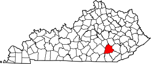
London, KY Micropolitan Statistical Area

The London, KY Micropolitan Statistical Area is a United States Census Bureau defined Micropolitan Statistical Area located in the vicinity of London, Kentucky. The London Micropolitan Statistical Area encompasses Laurel County entirely. The Micropolitan Statistical Area had a population of 52,715 at the 2000 Census. A July 1, 2009 U.S. Census Bureau estimate placed the population at 57,749.[1]
The London Micropolitan Statistical Area is part of the Corbin-London, KY Combined Statistical Area, which also contains the Corbin, KY Micropolitan Statistical Area.
Communities
Incorporated places
- London (Principal city)
Census-designated places
Note: All census-designated places are unincorporated.
Unincorporated places
Demographics
As of the census[2] of 2000, there were 52,715 people, 20,353 households, and 15,366 families residing in the μSA. There were 22,317 housing units at an average density of 51 per square mile (20/km2). The racial makeup of the county was 97.66% White, 0.63% Black or African American, 0.37% Native American, 0.35% Asian, 0.01% Pacific Islander, 0.08% from other races, and 0.90% from two or more races. 0.55% of the population were Hispanic or Latino of any race.
The median income for a household in the μSA was $27,015, and the median income for a family was $31,318. Males had a median income of $27,965 versus $19,757 for females. The per capita income for the μSA was $14,165.
References
- ↑ "Table 1. Annual Estimates of the Population of Metropolitan and Micropolitan Statistical Areas: April 1, 2000 to July 1, 2009 (CBSA-EST2009-01)" (CSV). 2009 Population Estimates. United States Census Bureau, Population Division. 2010-03-23. Retrieved 2010-06-08.
- ↑ "American FactFinder". United States Census Bureau. Retrieved 2008-01-31.
