Manitoba Highway 12
| ||||
|---|---|---|---|---|
| MOM's Way | ||||
| Route information | ||||
| Length: | 256 km (159 mi) | |||
| Major junctions | ||||
| South end: |
| |||
|
| ||||
| North end: | Grand Beach | |||
| Highway system | ||||
| ||||

Provincial Trunk Highway 12 (PTH 12) is a provincial highway in the Canadian province of Manitoba. It runs from the U.S. border (where it meets with Minnesota State Highway 313) to a dead end in Grand Beach. PTH 12 forms the Manitoba section of MOM's Way, a route from Thunder Bay to Winnipeg.[1] Except for a 22 kilometre stretch of four lanes between Steinbach and Highway 1, PTH 12 is a two-lane highway.
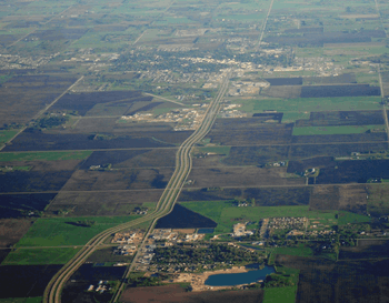
Highway 12 running south from Blumenort (lower) to Steinbach (upper) as a four lane road and can be seen exiting Steinbach to the upper part of the photo as a 2 lane highway.
Major intersections
| Division | Location | km | mi | Destinations | Notes |
|---|---|---|---|---|---|
| Piney | | 0 | 0.0 | Minnesota state line | |
| | 21 | 13 | |||
| | 31 | 19 | |||
| | 48 | 30 | |||
| | 62 | 39 | |||
| Stuartburn | | Road 53 East - Sundown | former PR 402 south | ||
| | 84 | 52 | |||
| La Broquerie | Zhoda | 94 | 58 | former PR 208 south | |
| | 102 | 63 | |||
| Hanover | | 113 | 70 | ||
| | 121 | 75 | |||
| Steinbach | 128 | 80 | |||
| Hanover | | 133 | 83 | south end of PR 311 overlap | |
| | 137 | 85 | north end of PR 311 overlap | ||
| Ste. Anne | | 144 | 89 | ||
| | 145 | 90 | interchange | ||
| | 147 | 91 | interchange; PTH 1 exit 375 | ||
| Taché | | 152 | 94 | ||
| Springfield | Anola | 166 | 103 | ||
| Brokenhead | | 176 | 109 | ||
| | 185 | 115 | |||
| | 187 | 116 | south end of PTH 44 overlap | ||
| | Road 41 East - Beausejour | former PTH 4B east | |||
| | 197 | 122 | north end of PTH 44 overlap | ||
| | 205 | 127 | |||
| Dencross | 218 | 135 | |||
| St. Clements | | 232 | 144 | Stead Road - Gull Lake, Stead | former PR 304 |
| Alexander | | 237 | 147 | south end of PTH 59 overlap | |
| | 239 | 149 | |||
| | 247 | 153 | north end of PTH 59 overlap | ||
| | 251 | 156 | |||
| Grand Marais | 254 | 158 | Grand Beach Provincial Park | ||
| 1.000 mi = 1.609 km; 1.000 km = 0.621 mi | |||||
See also
References
This article is issued from Wikipedia - version of the 5/16/2016. The text is available under the Creative Commons Attribution/Share Alike but additional terms may apply for the media files.