U.S. Route 20 in Massachusetts
| |||||||
|---|---|---|---|---|---|---|---|
|
Map of Massachusetts with US 20 highlighted in red | |||||||
| Route information | |||||||
| Maintained by MassDOT | |||||||
| Length: | 153.44 mi[1] (246.94 km) | ||||||
| Existed: | 1926[2] – present | ||||||
| Major junctions | |||||||
| West end: |
| ||||||
| East end: |
| ||||||
| Highway system | |||||||
| |||||||


The cross-country U.S. Route 20 runs its easternmost 153 miles (246 km) in the U.S. state of Massachusetts. The highway crosses the state border from New Lebanon, New York into Hancock, Massachusetts, and runs eastward into Boston, where it ends at Route 2 in Kenmore Square. It spends the vast majority of its journey paralleling the Massachusetts Turnpike, which has largely superseded US-20 for through travel. Still, US-20 directly serves many towns and local business areas which the Turnpike bypasses.[3]
U.S. Route 20 is the longest numbered highway in the entire country and also holds the distinction of being the longest numbered highway in the state, edging out Route 28 by merely a mile (Route 28 is 151.92 miles (244.49 km) long).[1]
Parts of US 20 between the Worcester and Boston areas were also an alignment of the Boston Post Road, an early colonial highway designated in 1673 for carrying mail between New York City and Boston.[4] US 20 is still locally known as the "Boston Post Road" in the towns of Marlborough, Sudbury, Wayland, and Weston.[5]
Route description
Berkshire County
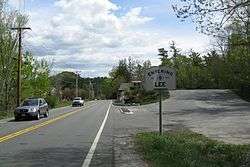
U.S. Route 20 begins its eastward trek crossing the New York state border into Hancock, Massachusetts, passing through the southern edge of the Pittsfield State Forest before entering Pittsfield and meeting the northern end of Route 41. The highway enters town and meets U.S. Route 7, near the western end of the cross-state Route 9. US-20 turns south along US-7, and the two routes form a concurrency into the town of Lenox. In Lenox, Route 7A splits off to serve the center of town, and US-20 splits from US-7 shortly thereafter to serve the town of Lee to the southeast. The highway passes through town and interchanges with the Mass Pike at Exit 2 south of town, near the eastern end of Route 102. US-20 turns to the east at this point, and closely parallels the Mass Pike for several miles, before entering the town of Becket and meeting Route 8. Route 8 northbound joins US-20 east to directly serve the town, while the Mass Pike passes south of Becket. Upon crossing through the town center, Route 8 splits from US-20, and the federal highway continues eastbound, passing into the town of Chester in Hampden County.
Hampden County
US-20 passes through the small town of Chester, and clips the southern portion of Huntington in Hampshire County before re-entering Hampden County and the town of Russell. US-20 passes through Russell, passes under the Mass Pike and meets the eastern end of Route 23, and continues into Westfield. US-20 crosses the U.S. Route 202/Route 10 concurrency in the center of the town, and intersects the northern end of Route 187 just to the east. US-20 begins to enter urban landscape as it crosses into West Springfield, making its way through the streets, intersecting U.S. Route 5, and crossing the Connecticut River into the city of Springfield. Immediately upon entering the city, US-20 interchanges with Interstate 91 at Exit 8, where it leaves the surface street (which is picked up by Route 20A, to join Interstate 291, which begins just to the south. (Note: Route 20A is NOT a former alignment of US-20. Before the construction of I-291, US-20 followed Main, State Streets, and Boston Road). US-20 is overlapped over most of I-291, running on the Interstate for about 5 miles (8.0 km), and leaving via Exit 5,[3] where it meets the eastern end of Route 20A and resumes its surface alignment on Page Boulevard in Springfield, rejoining its original alignment in Springfield on Boston Road. US-20, as Boston Road, crosses Route 21 and proceeds east into the town of Wilbraham, where it goes back to paralleling the Mass Pike for several more miles, until entering Palmer. In Palmer, US-20 meets the southern end of Route 181 and then intersects Route 32, which provides close access to the Mass Pike at Exit 8. US-20 and Route 32 share a short concurrency in Palmer, before US-20 splits east. Before leaving Palmer, Route 67 meets its southern end at US-20. Brimfield is the last town US-20 passes through in Hampden County; it enters from the west, crosses Route 19 in the center of town, and proceeds out of town to the east.
Worcester County
US-20 crosses into Worcester County and the town of Sturbridge, immediately meeting the southern end of Route 148. The route continues east where it meets the western end of Route 131 before interchanging with Interstate 84 at Exit 3. I-84 is another quick route to the Mass Pike, as it ends there less than a mile to the northeast. Route 49, a short connector to Route 9 in Spencer, has its southern terminus at US-20 east of the I-84 interchange. US-20 enters the town of Charlton at this point, passing through Charlton City where it meets the northern end of Route 169 and crosses over Route 31. Continuing east, US-20 enters the city of Auburn, south of Worcester, where it briefly overlaps Route 12. Route 12 provides direct access to the Mass Pike at Exit 10, while US-20 directly interchanges with Interstate 395, which becomes Interstate 290 north of the Mass Pike interchange. US-20 continues to the northeast, entering Millbury after briefly crossing into Worcester, where it interchanges with the Mass Pike at Exit 10A, as well as with Route 146 (which at this point is overlapped by Route 122A). The route re-enters Worcester, crossing over Route 122, which provides access to the Mass Pike at Exit 11. Leaving Worcester, US-20 enters the town of Shrewsbury, interchanging with Route 140 south of town. The highway continues to the northeast, passing southwest of Shrewsbury, and interchanging with Route 9. Heading almost due north at this point, US-20 crosses into Northborough, and turns back eastward, intersecting the western end of Route 135 in the town center. Two local roads, Church Street and Hudson Street, provide access to nearby I-290, which runs to the north. US-20 proceeds out of Northborough to the northeast, crossing into Marlborough and Middlesex County.
Middlesex County
US-20 enters Marlborough and interchanges with Interstate 495 (also referred to as the Outer Circumferential Highway) at Exit 24 west of town, effectively crossing into Boston's western suburbs. The route directly serves the center of town, crossing Route 85 in the process. It is in eastern Marlborough where US-20 begins to be famously referred to as Boston Post Road, and the road continues eastward into the town of Sudbury after briefly crossing into Framingham. US-20 passes through the southern part of the town, crossing over the Route 27/Route 126 concurrency in Wayland, and continues into Weston. US-20 does not intersect any major roads or numbered highways in Weston, but does follow an approximately mile-long bypass of the Boston Post Road (appropriately named Boston Post Road Bypass) between Highland Street and Wellesley Street, where US-20 rejoins the road and continues east into Waltham, where the Boston Post Road designation ends. Immediately upon crossing the town line, US-20 enters a rotary interchange with Interstate 95 (Route 128) at Exit 26, marking the change from suburban landscape to the urban landscape of metro Boston and having access to the Mass Pike. US-20 meets the eastern end of Route 117 and cuts through the center of Waltham, serving as Main Street east of Route 117. US-20 also meets the western end of Route 60, an urban highway serving Boston's northern suburbs, in Waltham. The highway continues into the city of Watertown serving as its Main Street to an intersection with Route 16, which passes west and north of Boston via various parkways on the edges of the city, through Cambridge and Malden. US-20 becomes North Beacon Street at this point and continues southwest as it crosses into the city of Boston over the North Beacon Street Bridge.
Suffolk County
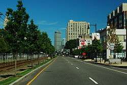
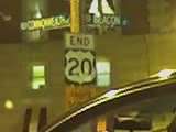
US-20 briefly continues as Leo F. Birmingham Parkway upon crossing into the Boston neighborhood of Brighton, immediately intersecting the western end of Soldiers Field Road Extension, before it turns right and continues as North Beacon Street again, and crosses under the Mass Pike (no interchange). US-20 continues towards downtown, passing through the Allston neighborhood of Boston. Upon crossing Cambridge Street, US-20 becomes Brighton Ave for a short distance. US-20 soon reaches Commonwealth Ave, and takes the eastbound routing over for Route 30, which ends at the intersection. At this point, the Brookline/Norfolk County border lies just feet south of the road, and US-20 passes through Boston University.[6] US-20 crosses Route 2 at the southern end of the Boston University Bridge, crossing over the Mass Pike for the final time. Route 2, via Mountfort Street, Park Drive, and Beacon Street, turns from south to east to meet US-20 at Kenmore Square. Upon meeting Route 2 again, US-20 meets its eastern terminus, with Route 2 taking Commonwealth Ave its final stretch to the Boston Public Garden and Route 28, where Route 2 meets its own end.[7]
U.S. Route 20's official eastern terminus is in Kenmore Square at the intersection of Commonwealth Avenue, Beacon Street, and Brookline Avenue.
Major intersections
| County | Location[8] | mi[8] | km | Exit | Destinations | Notes |
|---|---|---|---|---|---|---|
| Berkshire | Hancock | 0.000 | 0.000 | Continuation from New York | ||
| Pittsfield | 3.336 | 5.369 | Northern terminus of Route 41 | |||
| 7.431 | 11.959 | Western terminus of Route 9 | ||||
| 7.596 | 12.225 | Western end of US 7 concurrency | ||||
| Lenox | 12.845 | 20.672 | Northern terminus of Route 7A | |||
| 14.694 | 23.648 | Northern terminus of Route 183 | ||||
| 15.001 | 24.142 | Eastern end of US 7 concurrency | ||||
| Lee | 17.405 | 28.011 | Housatonic River | |||
| 18.766 | 30.201 | Exit 2 on Mass Pike | ||||
| 18.836 | 30.314 | Eastern terminus of Route 102 | ||||
| Becket | 25.719 | 41.391 | Western end of Route 8 concurrency | |||
| 30.895 | 49.721 | Eastern end of Route 8 concurrency | ||||
| Hampshire | Huntington | 41.831 | 67.320 | Southern terminus of Route 112 | ||
| Hampden | Russell | 48.016 | 77.274 | Eastern terminus of Route 23 | ||
| Westfield | 53.752 | 86.505 | Western end of US 202 / Route 10 concurrency | |||
| 54.004 | 86.911 | Eastern end of US 202 / Route 10 concurrency | ||||
| 55.770 | 89.753 | Northern terminus of Route 187 | ||||
| West Springfield | 61.577 | 99.099 | Rotary interchange | |||
| West Springfield–Springfield line | 61.697 | 99.292 | Connecticut River | |||
| Springfield | 62.739 | 100.969 | Western terminus of Route 20A; Exits 8 (east) and 9B (west) on I-91 north; Exits 8 (east) and 11 (west) on I-91 south | |||
| 63.135 | 101.606 | Western end of I-291 concurrency; Exit 1B on I-291 | ||||
| 63.261 | 101.809 | 2A | Chestnut Street | |||
| 64.012 | 103.017 | 3 | Armory Street | |||
| 65.082 | 104.739 | 4 | St. James Avenue – Chicopee Falls | |||
| 66.559 | 107.116 | Eastern terminus of Route 20A; Eastern end of I-291 concurrency; Exit 5A on I-291 | ||||
| 70.388 | 113.279 | Southern terminus of Route 21; eastern terminus of Route 141 | ||||
| Palmer | 78.782 | 126.787 | Southern terminus of Route 181 | |||
| 79.794 | 128.416 | Western end of Route 32 concurrency | ||||
| 80.775 | 129.995 | Eastern end of Route 32 concurrency | ||||
| 82.461 | 132.708 | Southern terminus of Route 67 | ||||
| Brimfield | 87.867 | 141.408 | ||||
| Worcester | Sturbridge | 92.813 | 149.368 | Southern terminus of Route 148 | ||
| 94.467 | 152.030 | Western terminus of Route 131 | ||||
| 94.831 | 152.616 | Exit 3 on I-84; left exit eastbound to I-90; left exit westbound to I-84 west | ||||
| 96.795 | 155.776 | Southern terminus of Route 49 | ||||
| Charlton | 99.991 | 160.920 | Northern terminus of Route 169 | |||
| 100.393 | 161.567 | |||||
| Oxford | 105.826 | 170.310 | ||||
| Auburn | 106.731 | 171.767 | Western end of Route 12 concurrency | |||
| 107.413 | 172.864 | Eastern end of Route 12 concurrency | ||||
| 108.624 | 174.813 | Exit 6 on I-395 | ||||
| Millbury | 112.510 | 181.067 | Exit 10A on Mass Pike; Exit 10 on Route 146 Route 146 has an unsigned concurrency with Route 122A. | |||
| Worcester | 115.252 | 185.480 | Interchange | |||
| Shrewsbury | 117.548 | 189.175 | Interchange | |||
| Northborough | 120.697 | 194.243 | Interchange | |||
| 123.895 | 199.390 | Western terminus of Route 135 | ||||
| Middlesex | Marlborough | 127.683 | 205.486 | Exit 24 on I-495 | ||
| 129.519 | 208.441 | |||||
| Wayland | 139.707 | 224.837 | ||||
| Waltham | 144.589 | 232.693 | Rotary interchange; Exit 26 on I-95 | |||
| 145.808 | 234.655 | Eastern terminus of Route 117 | ||||
| 147.073 | 236.691 | Western terminus of Route 60 | ||||
| Watertown | 149.373 | 240.393 | ||||
| Charles River | 150.683 | 242.501 | North Beacon Street Bridge | |||
| Suffolk | Boston | 152.654 | 245.673 | Eastern terminus of Route 30 | ||
| 153.365 | 246.817 | |||||
| 154.11 | 248.02 | Eastern terminus of US 20 | ||||
1.000 mi = 1.609 km; 1.000 km = 0.621 mi
| ||||||
Suffixed routes
| |
|---|---|
| Location: | Springfield |
| Length: | 4.14 mi[9] (6.66 km) |
Route 20A is a state highway located entirely within Springfield, Massachusetts, United States. The route, an alternate route of U.S. Route 20, parallels the section of US 20 concurrent with Interstate 291. The western terminus is at US 20 and Interstate 91 in downtown Springfield east of where US 20 crosses the Connecticut River on the North End Bridge. The eastern terminus is at US 20 and I-291 northeast of the city.
This alignment provides an alternate to Interstate 291, which overlaps US 20 for much of its length, but was originally an alternate to old US 20, which ran down State Street and Boston Road. This route was therefore never part of US 20, but has served as an alternate to two separate routes.
- Major intersections
The entire route is in Springfield, Hampden County.
| mi[9] | km | Destinations | Notes | ||
|---|---|---|---|---|---|
| 0.00 | 0.00 | Continuation beyond western terminus | |||
| 0.05 | 0.080 | Western terminus; exit 9 on I-91; no westbound access to I-91 south | |||
| 0.31 | 0.50 | ||||
| 4.00 | 6.44 | Eastern terminus; exit 5 on I-291 | |||
| 4.15 | 6.68 | Continuation beyond eastern terminus | |||
| 1.000 mi = 1.609 km; 1.000 km = 0.621 mi | |||||
References
- 1 2 Executive Office of Transportation, Office of Transportation Planning - 2007 Road Inventory
- ↑ "east–west Routes - US 2 to US 98 (& US 400) - Even numbered US highways". Retrieved 9 October 2014.
- 1 2 Roads and Highways of the Pioneer Valley - US 20
- ↑ S.H. Holbrook, The Old Post Road: The Story of the Boston Post Road, (McGraw-Hill, 1962)
- ↑ Google (June 8, 2009). "U.S. Route 20 in Massachusetts" (Map). Google Maps. Google. Retrieved June 8, 2009.
- ↑ "Boston University maps, retrieved August 5, 2009". Retrieved 9 October 2014.
- ↑ "MapQuest Maps:". Retrieved 9 October 2014.
- 1 2 MassDOT Planning Division. "Massachusetts Route Log Application". Massachusetts Department of Transportation. Retrieved September 17, 2014.
- 1 2 Planning Division (2012). "Massachusetts Highway Route Log". Massachusetts Department of Transportation. Retrieved March 8, 2015.
External links
| Wikimedia Commons has media related to U.S. Route 20 in Massachusetts. |
| Previous state: New York |
Massachusetts | Next state: Terminus |