Monuriki

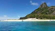
Monuriki is an uninhabited tiny island in the Pacific Ocean, off the coast of Viti Levu in a group of islands known as the Mamanuca Islands. The island is of volcanic origin and is approximately 1 kilometre (0.62 mi) long and 600 metres (660 yd) wide. The land area is approximately 0.4 square kilometres (100 acres) surrounded on all sides by a coral reef. The highest point is 178 metres (584 ft). This volcanic islet is part of the Atolls islands and related to a group of three islets in the larger group of Fiji Islands, called "Mamanuca". The islet is surrounded by coral reef; it also includes volcanic rocks, lagoons, and several small beaches, including some white sand beaches.
Geography
Monuriki has a length of 1.15 kilometres (0.71 mi) and a width of 600 metres (660 yd). The island is slightly mountainous, reaching a maximum height of 178 metres (195 yd) in the south-east.[1]
Monuriki is the smallest islet and the southernmost of a small group of three islets, west of Tavua at coordinates 17 ° 36 '32 "South, 177 ° 2' 2"East . The archipelago are very frequently visited tourist resorts and some islets are private. Some tourists people and travel agents refer to Monuriki as Cast Away island (see below), but the name is misleading, since Castaway Island, or Qalito, is another island of the Mamanuca Islands.
Flora and fauna


The vegetation consists mainly of higher screw pines, or pandanus, coconut, (Cocos nucifera) and associated species of coastal forests. The low vegetation has been eroded in the past by herds of goats up on the rocks, decreasing the availability of food to the indigenous iguana population. There is a captive breeding program for iguanas, being run at Kula Eco Park by the National Trust of the Fiji Islands (NTF) and funded by the Critical Ecosystem Partnership Fund (CEPF).[2]
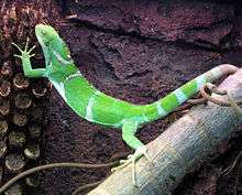
Monuriki is one of the few places on which the endangered Fiji crested iguana, or Brachylophus vitiensis, live. These iguanas feed on a wide range of plants and insects, and spend most of their time camouflaged in the branches of trees.[3] Only a few thousand Fiji crested iguanas live on the three tiny islands of western Fiji: Yadua Tabu, Macuata and Monuriki.
The Brachylophus vitiensis was first featured in a film when Dr. John Gibbons, of the University of the South Pacific, was invited to the screening of the movie Blue Lagoon.[4] The director filmed part of the movie on a remote island, and included shots of the native wildlife to enhance the feel of the movie, including a large colorful iguanid.[4] Gibbons, who had been studying the Fiji banded iguana at the time, travelled to Monuriki and identified it as a distinct species.[4] The species only lives in dry forest habitats, which are one of the most threatened vegetation types in the Pacific.[5] The species was once known to live on 14 islands in the western part of Fiji; however, recent surveys between 2002 and 2004 have only confirmed the species to be living on three islands: Yadua Tabu, Monuriki, and Macuata.[5] Yadua Tabu holds the highest proportion of the species, containing approximately 98% of all individuals, an estimated 6,000 animals. The Yadua Tabu iguanas are the only legally protected population, as Yadua Tabu is a National Trust of Fiji reserve and lacks the feral goats which have destroyed the lizard's habitat on other islands.[5] Monuriki is also a breeding ground for some sea turtles.
The forests in smaller, offshore, islands are tropical and subtropical dry broadleaf forests, which are highly vulnerable to being burnt, as well as being vulnerable to deforestation; overgrazing and exotic species can also quickly alter natural communities. Restoration of the forests is possible but challenging, particularly if degradation has been intense and persistent. Degrading dry broadleaf forests often leave thorny shrublands, thickets, or dry grasslands in their place. Tropical dry forests include both deciduous and semi-deciduous forests. A recent work by Howard Nelson suggests that areas which were formerly classified as evergreen forest also fit the criteria for dry forests.
In phytosociology, description of forest associations was physiognomically based. Many of his forest associations overlap modern ideas of dry and moist forests. The climate in Fiji is tropical marine and is consistently warm for the majority of the year, with extreme weather being a rarity. The warm season is from November till April, and the cooler season May to October. Temperatures in the cool season average 22 °C (72 °F).
The level of rainfall varies, although the warmer season experiences heavier rainfall, especially inland. Winds are moderate, though cyclones occur about once a year, or between ten and twelve times a decade.[6]
The group of Monuriki is a number of tiny rocky islets in rocky basalt and with several rocky islets, consisting broken cliffs and hills, coasts and corals and a few golden sand coves.
The group of islets has a drier climate and different habitat from the rain forests that cover most of the Fiji islands. Although not as rich as the rainforest, the plant life of the coast is quite varied, including a number of endemic species. The coast is traditionally home to a number of endangered animals, including terrestrial and marine birds. See List of birds of Fiji. Dry forests are always vulnerable to forest fires, and human intervention. The original vegetation of the coast has been cleared for farming, particularly cattle ranching. There are remains of a coconut plantation. Only two percent of natural dry forest remaining, and it is located in isolated patches, none of which are in protected areas. Dry forests are elected for urban areas, farms and farming communities all along the coast.
Pandanus is common in the littoral habitat, and is a component of strandline and coastal vegetation, including grassy or swampy woodlands, secondary forests, and scrub thickets developed on makatea (raised fossilized coralline limestone terraces). It occurs on the margins of mangroves and swamps, as an understory tree in the plantation of coconut and forest, either planted or naturalized. Associated species of native habitat include creepers such as Ipomoea pescaprae, Canavalia sericea, and Vigna marina. Other coastal thickets and forest associates include Acacia simplex, Amaroria soulameoides, Tournefortia argentea, Barringtonia asiatica, Bruguiera gymnorrhiza, Calophyllum inophyllum, Casuarina equisetifolia, Cerbera manghas, Chrysobalanus icaco, Cocos nucifera, Cordia subcordata, Excoecaria agallocha, Guettarda speciosa, Hernandia nymphaeifolia, Hibiscus tiliaceus, Intsia bijuga, Morinda citrifolia, Podocarpus neriifolius, Santalum insulare, Scaevola taccada, Schleinitzia insularum, Terminalia catappa, Terminalia littoralis, Thespesia populnea, and Vitex trifoliata. Peat swamp associates include Sphagnum cuspidatum and various sedges.
While all pandanus is distributed in the tropical Pacific islands, low islands of the Polynesia and Micronesia are their favorite spot: it covers the barren atolls. The tree is grown and propagated from shoots that form spontaneously in the axils of lower leaves. Its fruit can float and spread to other islands without help from man. The fruit is an edible drupe. They grow wild mainly in seminatural vegetation in littoral habitats throughout the tropical and subtropical Pacific, where it can withstand drought, strong winds, and salt spray. Cocos nucifera was probably aided in many cases by seafaring people. Coconut fruit in the wild is light, buoyant and highly water resistant, and evolved to disperse significant distances via marine currents.[7] It has been collected from the sea as far north as Norway.[8]
History
After the Mutiny on the Bounty on 28 April 1789 William Bligh sailed his launch through the open area of the northern Fiji Islands. On his way to Kupang, he became the first European to visit several islands in the Fiji group, which is why the sea area north of the Fiji island of Viti Levu, which was crossed here and in the Monuriki, is named "Bligh Water".
Relationship to Cast Away
This island was a filming location for the 2000 Robert Zemeckis' film, Cast Away, starring Tom Hanks as the plane wrecked protagonist Chuck Noland.[9][10][11] The island became a tourist attraction following the film's release. (In the plot of the film, the island is described as being "about 600 miles south of the Cook Islands," although there is no land between the southern-most Cook Islands of Mangaia and Antarctica.) More than 100 people in the film team lived on the island during the production.
References
- ↑ Peter S. Harlow et. al.: The decline of the endemic Fijian crested iguana Brachylophus vitiensis in the Yasawa and Mamanuca archipelagos, western Fiji. in: Oryx, 41(1), 44–50 doi:10.1017/S0030605307001639, hier S. 48.
- ↑ "The News. September 2010" (PDF). Pacific Invasive Initiative. September 2010. p. 2. Archived from the original (PDF) on 3 April 2012. Retrieved 3 April 2012.
- ↑ IUCN RedList:Brachylophus vitiensis (English)
- 1 2 3 Robert George Sprackland (1992). Giant lizards. Neptune, NJ: T.F.H. Publications. ISBN 0-86622-634-6.
- 1 2 3 Aruna Chand Lata (2002). "REPORT ON IGUANA SEMINAR". BSSP NEWSLETTER. Fiji: University of the South Pacific Division of Biology — School of Biological, Chemical and Environmental Sciences. Retrieved 6 October 2008.
- ↑ Fiji Government Online Portal: Our Country. Retrieved 26 April 2010.
- ↑ Foale, Mike. (2003). The Coconut Odyssey – the bounteous possibilities of the tree of life. Australian Centre for International Agricultural Research. Retrieved 2009-05-30.
- ↑ Ferguson, John. (1898). All about the "coconut palm" (Cocos nucifera) (2nd edition).
- ↑ ? Note_id = 91483425885 detailed presentation of the film location of choice (English)
- ↑ Fiji. Korina Miller, Robyn Jones, Leonardo Pinheiro. Lonely Planet. 2003. p. 54. ISBN 1-74059-134-8.
- ↑ Fiji. Korina Miller, Robyn Jones, Leonardo Pinheiro. Lonely Planet. 2003. p. 54. ISBN 1-74059-134-8.
Coordinates: 17°36′36″S 177°02′03″E / 17.610°S 177.0343°E
