Mound, Texas
| Mound, Texas | |
|---|---|
| Unincorporated community | |
 Mound  Mound Location within the state of Texas | |
| Coordinates: 31°21′7″N 97°38′15″W / 31.35194°N 97.63750°WCoordinates: 31°21′7″N 97°38′15″W / 31.35194°N 97.63750°W | |
| Country | United States |
| State | Texas |
| County | Coryell |
| Elevation | 692 ft (211 m) |
| Time zone | Central (CST) (UTC-6) |
| • Summer (DST) | CDT (UTC-5) |
| ZIP codes | 76558 |
| GNIS feature ID | 1363217 |
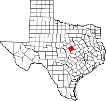
Mound is an unincorporated community in Coryell County, Texas, United States. Its elevation is 692 feet (211 m).[1] Although Mound is unincorporated, it has a post office, with the ZIP code of 76558.[2]
Mound was settled early in the 1850s, before most other communities in Coryell County; it did not receive a railroad line until 1882 or a post office until 1884. Although Mound was long a center of education (it was named for the local White Mound School), in 1971 its schools were merged into the Gatesville Independent School District. Today, FM 1829 passes through Mound.[3]
References
- ↑ U.S. Geological Survey Geographic Names Information System: Mound, Texas
- ↑ Zip Code Lookup
- ↑ Smyrl, Vivian Elizabeth (June 15, 2010). "Mound, TX". Handbook of Texas (online ed.). Texas State Historical Association.
External links
This article is issued from Wikipedia - version of the 7/30/2016. The text is available under the Creative Commons Attribution/Share Alike but additional terms may apply for the media files.
