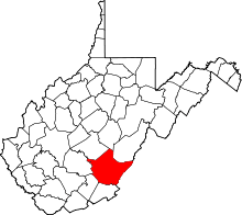
| [3] |
Name on the Register |
Image |
Date listed[4] |
Location |
City or town |
Description |
|---|
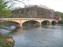
| 1 |
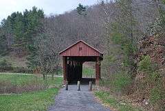
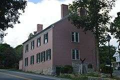
Alderson Bridge |
|
000000001991-12-04-0000December 4, 1991
(#91001730) |
Monroe St. across the Greenbrier River
37°43′29″N 80°38′36″W / 37.724722°N 80.643333°W / 37.724722; -80.643333 (Alderson Bridge) |
Alderson |
|
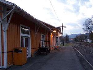
| 2 |
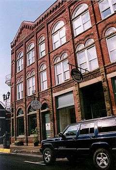
Alderson Historic District |
|
000000001993-11-12-0000November 12, 1993
(#93001231) |
Roughly along Monroe St., Riverview Dr., Railroad Ave., and adjacent streets
37°43′29″N 80°38′32″W / 37.724722°N 80.642222°W / 37.724722; -80.642222 (Alderson Historic District) |
Alderson |
|
| 3 |
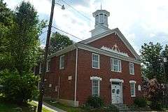
Alexander W. Arbuckle I House |
Upload image |
000000001976-05-03-0000May 3, 1976
(#76001933) |
2 miles north of Lewisburg on Arbuckle Lane
37°51′41″N 80°25′24″W / 37.861389°N 80.423333°W / 37.861389; -80.423333 (Alexander W. Arbuckle I House) |
Lewisburg |
|
| 4 |
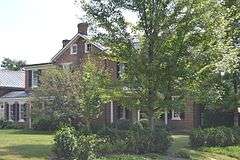
Argabrite House |
Upload image |
000000002009-04-16-0000April 16, 2009
(#08001236) |
504 Virginia St.
37°43′47″N 80°38′11″W / 37.729761°N 80.636494°W / 37.729761; -80.636494 (Argabrite House) |
Alderson |
|
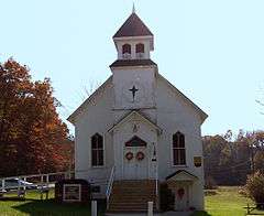
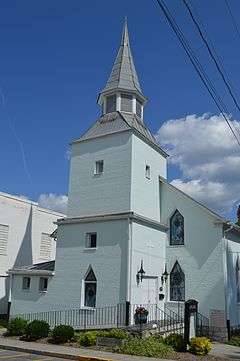
| 5 |
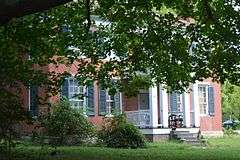
Sam Black Church |
|
000000001999-03-05-0000March 5, 1999
(#99000288) |
U.S. Route 60 at its junction with County Route 60/5
37°53′55″N 80°37′50″W / 37.898611°N 80.630556°W / 37.898611; -80.630556 (Sam Black Church) |
Smoot |
|
| 6 |
Blue Bend Forest Camp |
Upload image |
000000001994-04-20-0000April 20, 1994
(#94000352) |
4 miles west of WV 92 on Alvon-Blue Bend-Anthony Rd., County Route 16/2
37°55′14″N 80°16′06″W / 37.920556°N 80.268333°W / 37.920556; -80.268333 (Blue Bend Forest Camp) |
Alvon |
|
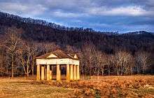
| 7 |
Blue Sulphur Springs Pavilion |
|
000000001992-10-29-0000October 29, 1992
(#92001481) |
County Route 25, 9 miles north of Alderson
37°49′42″N 80°38′30″W / 37.828333°N 80.641667°W / 37.828333; -80.641667 (Blue Sulphur Springs Pavilion) |
Blue Sulphur Springs |
|
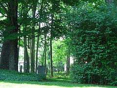
| 8 |
Confederate Cemetery at Lewisburg |
|
000000001988-02-02-0000February 2, 1988
(#87002535) |
Maple St. and U.S. Route 60, Library Park
37°48′07″N 80°27′06″W / 37.801944°N 80.451667°W / 37.801944; -80.451667 (Confederate Cemetery at Lewisburg) |
Lewisburg |
|
| 9 |
David S. Creigh House |
Upload image |
000000001975-11-12-0000November 12, 1975
(#75001888) |
Southwest of Lewisburg off the Davis-Stuart Rd.
37°46′14″N 80°28′33″W / 37.770556°N 80.475833°W / 37.770556; -80.475833 (David S. Creigh House) |
Lewisburg |
|
| 10 |
Deitz Farm |
|
000000001992-04-17-0000April 17, 1992
(#92000304) |
Junction of County Routes 28 and 60/32
37°54′34″N 80°40′10″W / 37.909444°N 80.669444°W / 37.909444; -80.669444 (Deitz Farm) |
Meadow Bluff |
|
| 11 |
Edgefield |
Upload image |
000000002012-12-12-0000December 12, 2012
(#12001047) |
461 Brownstown Rd.
37°59′47″N 80°21′21″W / 37.99631°N 80.35588°W / 37.99631; -80.35588 (Edgefield) |
Renick |
|
| 12 |
Elmhurst |
Upload image |
000000001975-06-05-0000June 5, 1975
(#75001887) |
U.S. Route 60 at the Greenbrier River
37°46′50″N 80°23′47″W / 37.780556°N 80.396389°W / 37.780556; -80.396389 (Elmhurst) |
Caldwell |
|
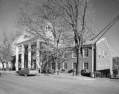
| 13 |
Greenbrier County Courthouse and Lewis Spring |
|
000000001973-08-17-0000August 17, 1973
(#73001900) |
Corner of Court and Randolph Sts.
37°48′11″N 80°26′46″W / 37.803056°N 80.446111°W / 37.803056; -80.446111 (Greenbrier County Courthouse and Lewis Spring) |
Lewisburg |
|
| 14 |
The Greenbrier |
|
000000001974-10-09-0000October 9, 1974
(#74002000) |
Off U.S. Route 60
37°47′41″N 80°20′09″W / 37.794722°N 80.335833°W / 37.794722; -80.335833 (The Greenbrier) |
White Sulphur Springs |
|
| 15 |
Hartland |
Upload image |
000000001975-06-10-0000June 10, 1975
(#75001889) |
2 miles west of Lewisburg on Houfnaggle Rd.
37°48′06″N 80°28′29″W / 37.801667°N 80.474722°W / 37.801667; -80.474722 (Hartland) |
Lewisburg |
|
| 16 |
Herns Mill Covered Bridge |
|
000000001981-06-04-0000June 4, 1981
(#81000598) |
County Route 40 near its junction with County Route 60/11
37°49′57″N 80°30′18″W / 37.8325°N 80.505°W / 37.8325; -80.505 (Herns Mill Covered Bridge) |
Lewisburg |
|
| 17 |
Hokes Mill Covered Bridge |
|
000000001981-06-04-0000June 4, 1981
(#81000599) |
County Route 62 at Hokes Mill crossing of Second Creek
37°41′50″N 80°31′30″W / 37.697222°N 80.525°W / 37.697222; -80.525 (Hokes Mill Covered Bridge) |
Ronceverte |
|
| 18 |
Homeplace |
Upload image |
000000002008-01-17-0000January 17, 2008
(#07001415) |
U.S. Route 219 North
37°54′43″N 80°22′55″W / 37.911944°N 80.381944°W / 37.911944; -80.381944 (Homeplace) |
Frankford |
|
| 19 |
Hopkins Mountain Historic District |
Upload image |
000000001994-04-14-0000April 14, 1994
(#94000353) |
Along Forest Road 139 (Hopkins Mountain Rd), north of County Road 16/2 (Alvon-Blue Bend-Anthony Road), approximately 4 miles west of WV 92
37°57′08″N 80°15′52″W / 37.952222°N 80.264444°W / 37.952222; -80.264444 (Hopkins Mountain Historic District) |
Alvon |
|
| 20 |
Lewisburg Historic District |
|
000000001978-07-07-0000July 7, 1978
(#78002795) |
Irregular pattern along U.S. Routes 60 and 219
37°48′06″N 80°26′44″W / 37.801667°N 80.445556°W / 37.801667; -80.445556 (Lewisburg Historic District) |
Lewisburg |
|
| 21 |
Maple Street Historic District |
|
000000001988-04-06-0000April 6, 1988
(#87002529) |
107-121 Maple St.
37°48′18″N 80°26′58″W / 37.805000°N 80.449444°W / 37.805000; -80.449444 (Maple Street Historic District) |
Lewisburg |
|
| 22 |
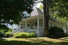
McClung's Price Place |
|
000000002007-08-03-0000August 3, 2007
(#07000782) |
699 Savannah Ln.
37°53′39″N 80°24′59″W / 37.894222°N 80.416444°W / 37.894222; -80.416444 (McClung's Price Place) |
Lewisburg |
|
| 23 |
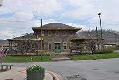
Meadow River Lumber Building |
Upload image |
000000001997-11-13-0000November 13, 1997
(#97001411) |
U.S. Route 219 South at State Fair of West Virginia
37°46′39″N 80°27′45″W / 37.7775°N 80.4625°W / 37.7775; -80.4625 (Meadow River Lumber Building) |
Fairlea |
|
| 24 |
Alexander McVeigh Miller House |
Upload image |
000000001978-12-15-0000December 15, 1978
(#78002794) |
Hemlock Ave.
37°43′53″N 80°38′05″W / 37.731389°N 80.634722°W / 37.731389; -80.634722 (Alexander McVeigh Miller House) |
Alderson |
|
| 25 |
Morlunda |
Upload image |
000000001977-03-25-0000March 25, 1977
(#77001374) |
Northwest of Lewisburg on County Route 40
37°49′54″N 80°29′28″W / 37.831667°N 80.491111°W / 37.831667; -80.491111 (Morlunda) |
Lewisburg |
|
| 26 |
Mountain Home |
Upload image |
000000001980-11-28-0000November 28, 1980
(#80004020) |
Southwest of White Sulphur Springs on U.S. Route 60
37°46′24″N 80°21′10″W / 37.773333°N 80.352778°W / 37.773333; -80.352778 (Mountain Home) |
White Sulphur Springs |
|
| 27 |
Mt. Tabor Baptist Church |
|
000000001976-12-12-0000December 12, 1976
(#76001934) |
Court and Foster Sts.
37°48′07″N 80°26′50″W / 37.801806°N 80.447222°W / 37.801806; -80.447222 (Mt. Tabor Baptist Church) |
Lewisburg |
|
| 28 |
John A. North House |
|
000000001974-10-09-0000October 9, 1974
(#74001998) |
100 Church St.
37°48′11″N 80°26′54″W / 37.803056°N 80.448333°W / 37.803056; -80.448333 (John A. North House) |
Lewisburg |
|
| 29 |
Oakhurst Links |
Upload image |
000000002001-12-04-0000December 4, 2001
(#01001327) |
1 Montague Dr.
37°49′41″N 80°16′47″W / 37.828056°N 80.279722°W / 37.828056; -80.279722 (Oakhurst Links) |
White Sulphur Springs |
|
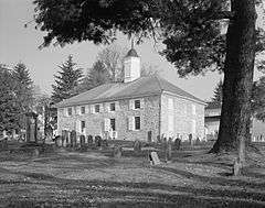
| 30 |
Old Stone Church |
|
000000001972-02-23-0000February 23, 1972
(#72001286) |
Church and Foster Sts.
37°48′04″N 80°26′55″W / 37.801111°N 80.448611°W / 37.801111; -80.448611 (Old Stone Church) |
Lewisburg |
|
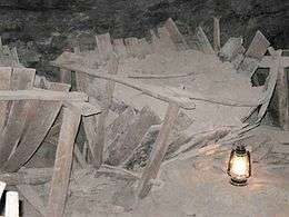
| 31 |
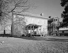
Organ Cave |
|
000000002005-05-05-0000May 5, 2005
(#05000397) |
WV 63, 0.5 miles east of its junction with U.S. Route 219
37°43′12″N 80°26′09″W / 37.72°N 80.435833°W / 37.72; -80.435833 (Organ Cave) |
Ronceverte |
|
| 32 |
Gov. Samuel Price House |
|
000000001975-06-20-0000June 20, 1975
(#75001890) |
224 N. Court St.
37°48′15″N 80°26′39″W / 37.804167°N 80.444167°W / 37.804167; -80.444167 (Gov. Samuel Price House) |
Lewisburg |
|
| 33 |
Renick Farm |
|
000000001997-04-04-0000April 4, 1997
(#96000525) |
U.S. Route 219 near its junction with County Route 9
37°59′00″N 80°21′04″W / 37.983333°N 80.351111°W / 37.983333; -80.351111 (Renick Farm) |
Renick |
|
| 34 |
Ronceverte Historic District |
|
000000002005-05-06-0000May 6, 2005
(#05000396) |
Roughly along Main St., Pocahontas, Monroe, and Greenbrier Avenues
37°45′00″N 80°28′03″W / 37.75°N 80.4675°W / 37.75; -80.4675 (Ronceverte Historic District) |
Ronceverte |
|
| 35 |
South Church Street Historic District |
|
000000001988-02-02-0000February 2, 1988
(#87002528) |
S. Church St.
37°48′02″N 80°27′00″W / 37.800556°N 80.450000°W / 37.800556; -80.450000 (South Church Street Historic District) |
Lewisburg |
|
| 36 |
Stone Manse |
Upload image |
000000002004-04-15-0000April 15, 2004
(#04000307) |
County Route 38 (Stonehouse Rd.)
37°47′52″N 80°22′45″W / 37.797778°N 80.379167°W / 37.797778; -80.379167 (Stone Manse) |
Caldwell |
|
| 37 |
Stuart Manor |
Upload image |
000000001973-07-27-0000July 27, 1973
(#73001901) |
Southwest of Lewisburg off U.S. Route 219
37°45′58″N 80°29′59″W / 37.766111°N 80.499722°W / 37.766111; -80.499722 (Stuart Manor) |
Lewisburg |
|
| 38 |
Supreme Court Library Building |
|
000000001972-02-23-0000February 23, 1972
(#72001287) |
U.S. Route 60 West and Courtney Dr.
37°48′12″N 80°26′53″W / 37.803333°N 80.448056°W / 37.803333; -80.448056 (Supreme Court Library Building) |
Lewisburg |
|
| 39 |
Tuckwiller Tavern |
Upload image |
000000001975-03-04-0000March 4, 1975
(#75001891) |
2 miles northwest of Lewisburg on U.S. Route 60
37°49′21″N 80°28′45″W / 37.8225°N 80.479167°W / 37.8225; -80.479167 (Tuckwiller Tavern) |
Lewisburg |
|
| 40 |
Tuscawilla |
Upload image |
000000001979-12-19-0000December 19, 1979
(#79002576) |
South of Lewisburg off U.S. Route 219
37°47′00″N 80°27′00″W / 37.783333°N 80.45°W / 37.783333; -80.45 (Tuscawilla) |
Lewisburg |
|
| 41 |
John Wesley Methodist Church |
|
000000001974-06-05-0000June 5, 1974
(#74001997) |
E. Foster St.
37°47′59″N 80°26′40″W / 37.799722°N 80.444444°W / 37.799722; -80.444444 (John Wesley Methodist Church) |
Lewisburg |
|
| 42 |
James Withrow House |
|
000000001974-12-31-0000December 31, 1974
(#74001999) |
200 N. Jefferson St.
37°48′14″N 80°26′35″W / 37.803750°N 80.443056°W / 37.803750; -80.443056 (James Withrow House) |
Lewisburg |
|
| 43 |
James Wylie House |
Upload image |
000000001990-02-05-0000February 5, 1990
(#89002318) |
208 E. Main St.
37°47′48″N 80°17′52″W / 37.796667°N 80.297778°W / 37.796667; -80.297778 (James Wylie House) |
White Sulphur Springs |
|