| [3] |
Name on the Register |
Image |
Date listed[4] |
Location |
Description |
|---|
| 1 |
Angels Landing Trail-West Rim Trail |
|
000000001987-02-14-0000February 14, 1987
(#86003707) |
South of Scout Lookout across the Virgin River and Refrigerator Canyon
37°16′06″N 112°56′58″W / 37.268333°N 112.949444°W / 37.268333; -112.949444 (Angels Landing Trail-West Rim Trail) |
|
| 2 |
Cable Creek Bridge |
|
000000001996-02-16-0000February 16, 1996
(#96000053) |
Floor of the Valley Rd. at milepost 4.48, south of Weeping Rock Parking Area entrance
37°16′13″N 112°56′19″W / 37.270278°N 112.938611°W / 37.270278; -112.938611 (Cable Creek Bridge) |
|
| 3 |
Cable Mountain Draw Works |
|
000000001978-05-24-0000May 24, 1978
(#78000281) |
North of Springdale in Zion National Park
37°15′57″N 112°55′59″W / 37.265833°N 112.933056°W / 37.265833; -112.933056 (Cable Mountain Draw Works) |
|
| 4 |
Canyon Overlook Trail |
|
000000001987-02-14-0000February 14, 1987
(#86003722) |
Across the highway from the parking area at the eastern end of the Zion-Mt. Carmel Tunnel to a point directly above the Great Arch of Zion
37°12′49″N 112°56′54″W / 37.213611°N 112.948333°W / 37.213611; -112.948333 (Canyon Overlook Trail) |
|
| 5 |
East Entrance Checking Station |
|
000000001987-02-14-0000February 14, 1987
(#86003711) |
Island in middle of State Route 9
37°14′01″N 112°52′06″W / 37.233611°N 112.868333°W / 37.233611; -112.868333 (East Entrance Checking Station) |
|
| 6 |
East Entrance Residence |
|
000000001987-02-14-0000February 14, 1987
(#86003712) |
Eastern entrance 150 feet north of State Route 9
37°14′01″N 112°52′41″W / 37.233611°N 112.878056°W / 37.233611; -112.878056 (East Entrance Residence) |
|
| 7 |
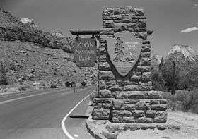
East Entrance Sign |
|
000000001987-07-07-0000July 7, 1987
(#86003710) |
East Entrance Checking Station on northern and southern sides of State Route 9
37°14′07″N 112°52′07″W / 37.235278°N 112.868611°W / 37.235278; -112.868611 (East Entrance Sign) |
|
| 8 |
East Rim Trail |
|
000000001987-07-07-0000July 7, 1987
(#86003723) |
Between Weeping Rock Parking Area and Observation Point
37°16′42″N 112°55′45″W / 37.278333°N 112.929167°W / 37.278333; -112.929167 (East Rim Trail) |
|
| 9 |
Emerald Pools Trail |
|
000000001987-02-14-0000February 14, 1987
(#86003725) |
Footbridge across the highway from Utah Parks Lodge proceeding west to the Lower Emerald Pool
37°14′58″N 112°57′16″W / 37.249444°N 112.954444°W / 37.249444; -112.954444 (Emerald Pools Trail) |
|
| 10 |
Flanigan Ditch |
|
000000001998-01-12-0000January 12, 1998
(#97001630) |
Zion National Park
37°12′53″N 112°58′28″W / 37.214722°N 112.974444°W / 37.214722; -112.974444 (Flanigan Ditch) |
|
| 11 |
Floor of the Valley Road |
|
000000001996-02-16-0000February 16, 1996
(#96000048) |
From its junction with the Zion-Mt. Carmel Highway along the North Fork of the Virgin River in Zion National Park
37°15′20″N 112°57′17″W / 37.255556°N 112.954722°W / 37.255556; -112.954722 (Floor of the Valley Road) |
|
| 12 |
Gateway to the Narrows Trail |
|
000000001987-07-07-0000July 7, 1987
(#86003726) |
Temple of Sinawava at the end of Zion Canyon Scenic Dr. to a point 1 mile north on the Virgin River
37°17′48″N 112°56′42″W / 37.296667°N 112.945°W / 37.296667; -112.945 (Gateway to the Narrows Trail) |
|
| 13 |
Grotto Camping Ground North Comfort Station |
|
000000001987-02-14-0000February 14, 1987
(#86003705) |
Grotto Picnic Area near Grotto Residence, east of Scenic Dr.
37°15′33″N 112°56′33″W / 37.259167°N 112.9425°W / 37.259167; -112.9425 (Grotto Camping Ground North Comfort Station) |
|
| 14 |
Grotto Camping Ground South Comfort Station |
|
000000001987-02-14-0000February 14, 1987
(#86003704) |
Grotto Picnic Area near Grotto Residence, east of Scenic Dr.
37°15′31″N 112°56′27″W / 37.258611°N 112.940833°W / 37.258611; -112.940833 (Grotto Camping Ground South Comfort Station) |
|
| 15 |
Grotto Trail |
|
000000001996-02-14-0000February 14, 1996
(#86003914) |
Zion National Park, 120 feet north of Zion Lodge extending south 0.2 miles parallel to the eastern side of Zion Canyon Scenic Dr.
37°15′01″N 112°57′26″W / 37.250278°N 112.957222°W / 37.250278; -112.957222 (Grotto Trail) |
|
| 16 |
Hidden Canyon Trail |
|
000000001987-02-14-0000February 14, 1987
(#86003731) |
Hidden Canyon junction on the East Rim Trail to the mouth of Hidden Canyon
37°16′01″N 112°55′50″W / 37.266944°N 112.930556°W / 37.266944; -112.930556 (Hidden Canyon Trail) |
|
| 17 |
Museum-Grotto Residence |
|
000000001987-02-14-0000February 14, 1987
(#86003721) |
Southeast of Grotto Picnic Area
37°15′28″N 112°57′03″W / 37.257778°N 112.950833°W / 37.257778; -112.950833 (Museum-Grotto Residence) |
|
| 18 |
Oak Creek Historic District |
|
000000001987-07-07-0000July 7, 1987
(#86003706) |
Off State Route 9 along bank of Oak Creek
37°12′40″N 112°59′10″W / 37.211111°N 112.986111°W / 37.211111; -112.986111 (Oak Creek Historic District) |
|
| 19 |
Oak Creek Irrigation Canal |
|
000000001987-07-07-0000July 7, 1987
(#86003738) |
Western side of the North Fork of the Virgin River, 1/8 miles north of the Virgin River Bridge to the northern side of Watchman Campground Entrance Rd.
37°12′09″N 112°59′28″W / 37.2025°N 112.991111°W / 37.2025; -112.991111 (Oak Creek Irrigation Canal) |
|
| 20 |
Parunuweap Canyon Archeological District |
|
000000001996-11-07-0000November 7, 1996
(#96001235) |
Address Restricted
|
|
| 21 |
Pine Creek Irrigation Canal |
|
000000001987-07-07-0000July 7, 1987
(#86003734) |
Eastern bank of the Virgin River 0.25 miles north of the Virgin River bridge to the southwestern end of the Watchman Residential Loop
37°12′06″N 112°58′40″W / 37.201667°N 112.977778°W / 37.201667; -112.977778 (Pine Creek Irrigation Canal) |
|
| 22 |
Pine Creek Residential Historic District |
|
000000001987-07-07-0000July 7, 1987
(#86003736) |
Western side of State Route 9 500 feet south of the bridge over the Virgin River
37°12′59″N 112°58′32″W / 37.216389°N 112.975556°W / 37.216389; -112.975556 (Pine Creek Residential Historic District) |
|
| 23 |
South Campground Amphitheater |
|
000000001987-02-14-0000February 14, 1987
(#86003717) |
South Campground
37°12′12″N 112°58′55″W / 37.203333°N 112.981944°W / 37.203333; -112.981944 (South Campground Amphitheater) |
|
| 24 |
South Campground Comfort Station |
|
000000001987-02-14-0000February 14, 1987
(#86003708) |
South Campground at the northern end of the campsite loop
37°12′14″N 112°58′21″W / 37.203889°N 112.9725°W / 37.203889; -112.9725 (South Campground Comfort Station) |
|
| 25 |
South Entrance Sign |
|
000000001987-02-14-0000February 14, 1987
(#86003713) |
South Entrance
37°12′04″N 112°59′22″W / 37.201111°N 112.989444°W / 37.201111; -112.989444 (South Entrance Sign) |
|
| 26 |
Zion Lodge Historic District |
|
000000001982-08-24-0000August 24, 1982
(#82001718) |
North of Springdale in Zion National Park; also west of State Route 9 on the eastern and western sides of The Zion Canyon Scenic Drive near Birch Creek
37°15′01″N 112°57′17″W / 37.250278°N 112.954722°W / 37.250278; -112.954722 (Zion Lodge Historic District) |
Second set of boundaries represents a boundary increase
|
| 27 |
Zion Nature Center-Zion Inn |
|
000000001987-02-14-0000February 14, 1987
(#86003719) |
North of South Campground facilities
37°12′21″N 112°58′25″W / 37.205833°N 112.973611°W / 37.205833; -112.973611 (Zion Nature Center-Zion Inn) |
|
| 28 |
Zion – Mount Carmel Highway |
|
000000001987-07-07-0000July 7, 1987
(#86003709) |
Between U.S. Route 89 and State Route 9
37°13′19″N 112°55′58″W / 37.221944°N 112.932778°W / 37.221944; -112.932778 (Zion – Mount Carmel Highway) |
|
![]() Media related to National Register of Historic Places listings in Zion National Park at Wikimedia Commons
Media related to National Register of Historic Places listings in Zion National Park at Wikimedia Commons







.jpg)


