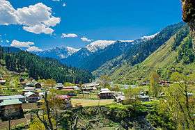
Neelam Valley
| Neelam Valley | |
|---|---|
| Valley | |
|
| |
 Neelam Valley | |
| Coordinates: 34°35′21″N 73°54′38″E / 34.5891°N 73.9106°ECoordinates: 34°35′21″N 73°54′38″E / 34.5891°N 73.9106°E | |
| Country |
|
| Region |
|
| District | Neelam District |
| Elevation | 1,615 m (5,299 ft) |
| Time zone | PST (UTC+5) |
Neelum Valley (also spelled Neelam Valley) (Urdu: وادیِ نیلم ) is a 144 km long bow-shaped thick forested region in Azad Kashmir in Pakistan. It is named after the Neelam river, which flows through the length of the valley.[1]
The valley is situated in the north-east of Muzaffarabad, running parallel to Kaghan Valley. The two valleys are only separated by snow-covered peaks, some over 4,000 meters (13,000 ft) above sea level.
Accessibility
The valley is connected from Muzaffarabad by Neelam road, which leads up to Kel. The road condition from Muzaffarabad to Athmuqam is very good and suitable for any kind of transport. From Keran to Kel road condition is not well and not suitable for low floor vehicles. In winters road onward Keran block due to heavy snowfall and it is very difficult to reach upper parts of the valley.
Vans serve is only Muzaffarabad to Athmuqam after every 30 minutes. Buses run daily between Muzaffarabad and Kel in good weather. Jeeps and horses are available to reach remote areas of the valley.
Accommodation and guest houses
Rest houses and lodge of AJK Tourism and Archeology Department are located in Keran, Kutton, Dawarrian, Sharda, Kel and Taobat for tourists stay. Some private hotels are also located there. A newly established tourism company "Horizon Hospitality" has set up its chain of hotels including Muzaffarabad, Keran, Shardah & Kel.
Historical places
In Neelam valley there are dozens of beautiful and historical places, Sharada Peeth in Sharda and Janawai town is one of the most beautiful and historical place in Neelam valley.
Towns and villages

Kundal Shahi: The village is located 74 kilometers (46 mi) from Muzaffarabad on the bank of Neelam River.
Jura: The most popular and most populated area in district neelum is jura, which is famous for its Bazar and its beautiful places and highest mountains. There are many colleges, private and government schools, hospitals and other facilities. In the village the Awan Family is mostly available.
Athmuqam: The chief town of valley located about 84 kilometres from Muzaffarabad. It is the headquarters of Neelum District. All the basic necessities of life are available there. Hotels, rest houses, market, post office, banks, hospitals, and telephone exchanges are also present.

Kutton: Also known as Jagran Valley, is a village and tourist resort located 82 kilometers (51 mi) from Muzaffarabad and 8 kilometers (5.0 mi) from Kundal Shahi on the bank of Jagran steam. Rest houses of AJK Tourism Department and WAPDA are located here. Some private rest houses and hotels are also available here for tourists stay.
Keran: 11 kilometers (6.8 mi) ahead from Athmuqam Keran resort is located on the bank of Neelam river at the altitude of 1,524 meters (5,000 ft)
Dowarian: It located 106 kilometers (66 mi) from Muzaffarabad and 22 kilometers (14 mi) from Athmuqam on the bank of Neelam River at the altitude of 1,615 meters (5,299 ft). A rest house of AJK Tourism Department located here for tourists stay. It is the base camp to Ratti Gali Lake.
Dudhnial It is a very famous and beautiful town of Neelum Valley. There is a government college, Girls high school and Hospital and other government offices. There are many shops and restaurants. Private rest houses facility is also available there.
Sharda: One of the beautiful spots of the Neelum valley located on the banks of the Neelum river at an altitude of 1,981 meters (6,499 ft), about 136 kilometers (85 mi) from Muzaffarabad.
Tehjian: Tehjian is most beautiful Village of Neelum Valley. Total Population of Tehjian is nearly 5000, There is 40 years old Middle School, but for highly populated village there is no Post Office or Basic Health Unit. Few private hotels and a tourist hostel of AJK Tourism Department located there for tourists stay.
Kel: The most beautiful village of the valley located 19 kilometers (12 mi) ahead from Sharda at the altitude of 6,879 feet (2,097 m). Few private hotels and a rest house of AJK Tourism Department located there for tourists stay. It also has bank, college, hospital and market.
Arang Kel: A village and tourist spot located on the hill top near Kel at the altitude of 8,379 feet (2,554 m) feet. It is accessible by a 2 kilometers (1.2 mi) trek from Kel.
Taobat: The last station of the valley. It is 200 kilometers (120 mi) from Muzaffarabad and 39 kilometers (24 mi) away from Kel. A tourist hotel of AJK Tourism Department and many private hotel with basic facilities located here for tourists.
Lakes

Chitta Katha Lake is located in Shonter valley, a sub valley of Neelam valley at the altitude of 13,500 feet (4,100 m). The lake is accessible from Kel by a 20 kilometers (12 mi) jeep track and then 5 kilometers (3.1 mi) hiking trek. Kel is the base camp to this lake.
Shounter Lake is a small lake located in Shounter valley at the altitude of 10,200 feet (3,100 m). It is accessible from Kel by a jeep track.
Ratti Gali Lake is located in Neelam valley at the altitude of 12,130 feet (3,700 m). The lake is accessible from Dowarian by a 17 kilometers (11 mi) jeepable track and then 2 km hiking trek. Dowarian is the base camp to this lake.
Saral Lake is located in Neelam Valley, Pakistan Occupied Kashmir(POK) at an altitude of 13,600 feet (4,100 m). Sharda is the base camp to this lake.
See also
References
- ↑ "Neelum Valley: The sapphire trail". Herald (Pakistan). 29 October 2015. Retrieved 14 February 2016.