Nobbys Head
| Nobbys Head (Whibayganba[1]) | |
| Coal Island[2], Nobbys Island | |
| headland[2] | |
 Nobbys Head, Newcastle | |
| Country | Australia |
|---|---|
| State | New South Wales |
| Regions | Sydney Basin (IBRA), Hunter |
| Local government area | Newcastle |
| City | Newcastle |
| Building | Nobbys Head Lighthouse |
| River | Hunter River |
| Location | Newcastle Harbour |
| - elevation | 27.5 m (90 ft) [1][3][4] |
| - coordinates | 32°55′24″S 151°48′04″E / 32.92333°S 151.80111°ECoordinates: 32°55′24″S 151°48′04″E / 32.92333°S 151.80111°E |
| For public | Yes (1st and 3rd Sunday per month) |
| Easiest access | Nobby's Beach carpark |
| Discovered by European | James Cook, RN |
| - date | 10 May 1770 |
| Timezone | AEST (UTC+10) |
| - summer (DST) | AEDT (UTC+11) |
| Website: Newcastle City Council webpage | |
| [5] | |
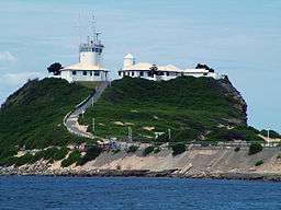
Nobbys Head (Aboriginal: Whibayganba[1]) is a headland located on the southern entrance to Newcastle Harbour, New South Wales, Australia. The headland is situated above the Hunter River and the Tasman Sea of the South Pacific Ocean.
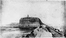
Originally called Coal Island, and then later Nobbys Island, the Island was connected to the mainland at first by the Macquarie Pier, completed in 1846, 38 years after commencement. The pier was eventually replaced by a breakwater. Sand accumulate along the breakwall to make Nobby's beach, and the sand and plants makes the isthmus appear natural.
The rock of the original island has significant tunnelling, which was completed during the 1850s using convict labour, with the aim of destroying the island.[1]
Nobbys Head Lighthouse[6] is located on the headland. The lighthouse is the third lighthouse built in New South Wales after the Macquarie Lighthouse in 1818 and the Hornby Lighthouse which was also built in 1858.[7] The lighthouse is included in Newcastle's coat of arms.[8]
Location and features

Nobbys Head was first sighted by Europeans on 10 May 1770 by Captain James Cook from the ship Endeavour and was described by Cook as:[9]
"A small round rock or Island, laying close under the land, bore South 82 degrees West, distance 3 or 4 Leagues".
It was not until the discovery of coal by Lt. John Shortland in 1797, that the island was viewed as having any significance.[10] In 1804, Signal Head was the first place in Newcastle that any form of navigational aid was established. Originally a coal burning light, it was changed over to oil in 1821 for a short period of time but was reverted to coal as the oil system was not reliable.[7]
Governor Macquarie ordered a pier to be built to join Coal island to Collier Point. The pier was started on 5 August 1818 and convict labour was used to do the construction. It took 38 years to complete the pier and during this time numerous convicts were lost to the sea due to the convicts having to work through all sea and weather conditions, night and day.[11][12]
Nobbys Head was thought to have been originally 62 metres (203 ft) high, however work done by the Coal River Working Party in 2010 has concluded that the original height was more likely 43 m (141 ft) high.[1] It was reduced to its current 27.5 m (90 ft) height because sailing ships were losing wind in the sails as they rounded Nobbys Head. The rock taken from Nobbys to reduce its height was used in the pier's construction.[3][4]
In 2010 it was reported that the NSW Government was examining the transfer of management of the headland from Newcastle Port Corporation to the Land Property Management Authority[13] for potential incorporation in a national park or reserve.
See also
References
- 1 2 3 4 5 Kerr, Roslyn (October 2011). "In Search of Nobby's Tunnels" (PDF). Coal River Working Party. University of Newcastle. Retrieved 10 October 2012.
- 1 2 "Nobbys Head". Geographical Names Register (GNR) of NSW. Geographical Names Board of New South Wales. Retrieved 23 March 2013.
- 1 2 "Wind In Ship Sails". Newcastle Port Corporation. Archived from the original on 29 August 2007. Retrieved 14 September 2007.
- 1 2 "Nobbys is the enduring landmark of Newcastle". Discover Newcastle. Newcastle City Council. Retrieved 14 September 2007.
- ↑ "Map of Nobbys Head, NSW". Bonzle Digital Atlas of Australia. Retrieved 23 March 2013.
- ↑ List of Lights, Pub. 111, The West Coasts of North and South America (Excluding Continental U.S.A. and Hawaii), Australia, Tasmania, New Zealand, and the Islands of the North and South Pacific Oceans (PDF). List of Lights. United States National Geospatial-Intelligence Agency. 2009. p. 124.
- 1 2 "The Nobbys Head Lighthouse at Newcastle". Lighthouses of New South Wales. Lighthouses of Australia Inc. Retrieved 14 September 2007.
- ↑ "Commonwealth heritage places in New South Wales (Nobbys Lighthouse, Newcastle East)". Department of the Environment, Water, Heritage and the Arts. Retrieved 21 July 2008.
- ↑ Cook, James (1893). "Captain Cook's Journal During the First Voyage Round the World (1768-1771)". London: Elliot Stock. Retrieved 29 August 2007.
- ↑ "First Discovery of Nobbys". Newcastle Port Corporation. Archived from the original on 29 August 2007. Retrieved 14 September 2007.
- ↑ "Australia's First Port". Newcastle Port Corporation. Archived from the original on 29 August 2007. Retrieved 14 September 2007.
- ↑ "Convict Built Pier". Newcastle Port Corporation. Archived from the original on 29 August 2007. Retrieved 14 September 2007.
- ↑ McMahon, Jeannette (23 November 2010). "Opening Nobbys headland to the public". ABC News. Newcastle, Australia. Retrieved 23 March 2013.