Ohio State Route 93
| |||||||
|---|---|---|---|---|---|---|---|
|
Route of SR 93 highlighted in red | |||||||
| Route information | |||||||
| Maintained by ODOT | |||||||
| Length: | 232.46 mi[1] (374.11 km) | ||||||
| Existed: | 1924 – present | ||||||
| Major junctions | |||||||
| South end: |
| ||||||
|
| |||||||
| North end: |
| ||||||
| Location | |||||||
| Counties: | Lawrence, Jackson, Vinton, Hocking, Perry, Muskingum, Coshocton, Tuscarawas, Holmes, Stark, Summit | ||||||
| Highway system | |||||||
| |||||||

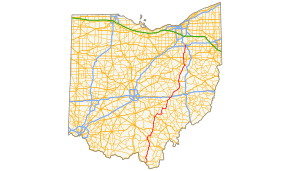
State Route 93 (SR 93) is a north–south highway that stretches from Ironton at U.S. Route 52 to State Route 261 in Akron. It is the third longest state route in Ohio. The route from Ironton to West Lafayette was once signed as State Route 75. In 1962, to eliminate confusion with an interstate in Ohio having the same number, State Route 75 was replaced by State Route 93 which had previously terminated in West Lafayette.
Route description
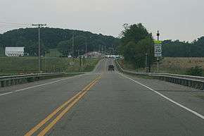
SR 93 begins at an interchange with U.S. Route 52 in Ironton and heads north. Within a few miles, the route goes through Wayne National Forest and Lake Vesuvius. After leaving Wayne National Forest, the route enters Jackson County and the town of Oak Hill where it intersects with SR 140 and SR 279. The route passes through less hilly areas as it once did in Lawrence County. The route passes through Jackson, and in the village of Coalton, State Route 93 makes a sharp turn eastward to Wellston, where it overlaps SR 327. After Wellston, SR 93 returns on its northerly route to Hamden, McArthur, Logan, New Lexington, Crooksville, and Zanesville. Between Zanesville and Ironton, SR 93 is a busy truck route and used by many travelers as well. Leaving Zanesville, the route is less traveled heading north to Canal Fulton, whence it gradually becomes more and more traveled as it approaches the Portage Lakes region. From this point to its northern terminus, it is a road in which traffic jams are expected during rush hour.
Major junctions
| County | Location | mi[1] | km | Destinations | Notes |
|---|---|---|---|---|---|
| Lawrence | Upper Township | 0.00– 0.19 | 0.00– 0.31 | Interchange | |
| Elizabeth Township | 9.55 | 15.37 | Eastern terminus of SR 522 | ||
| 11.56 | 18.60 | Southern terminus of SR 373 | |||
| Decatur Township | 14.33 | 23.06 | Northern terminus of SR 373 | ||
| Jackson | Jefferson Township | 27.84 | 44.80 | Eastern terminus of SR 140 | |
| Oak Hill | 30.86 | 49.66 | Southern end of SR 279 concurrency | ||
| 30.99 | 49.87 | Western terminus of SR 223 | |||
| 31.27 | 50.32 | Northern end of SR 279 concurrency | |||
| Lick Township | 42.24– 42.35 | 67.98– 68.16 | Interchange | ||
| Jackson | 43.38 | 69.81 | Southern end of SR 139 concurrency | ||
| 43.63 | 70.22 | Northern end of SR 139 concurrency | |||
| 43.82 | 70.52 | Southern terminus of SR 788 | |||
| Lick Township | 45.01– 45.13 | 72.44– 72.63 | Interchange | ||
| Coal Township | 51.19 | 82.38 | Northern terminus of SR 788 | ||
| Wellston | 52.62 | 84.68 | Southern end of SR 327 concurrency | ||
| 53.48 | 86.07 | Northern end of SR 327 concurrency | |||
| 54.15 | 87.15 | Southern terminus of SR 349 | |||
| Vinton | Hamden | 56.23 | 90.49 | Western terminus of SR 160 | |
| Clinton Township | 56.76 | 91.35 | Southern terminus of SR 368 | ||
| 60.38 | 97.17 | Northern terminus of SR 324 | |||
| McArthur | 63.11 | 101.57 | |||
| Elk Township | 66.14 | 106.44 | Southern terminus of SR 328 | ||
| Swan Township | 72.53 | 116.73 | |||
| Hocking | Logan | 85.99– 86.04 | 138.39– 138.47 | Interchange | |
| Falls Township | 91.44 | 147.16 | Southern terminus of SR 312 | ||
| 92.01 | 148.08 | Southern terminus of SR 668 | |||
| Perry | New Straitsville | 98.56 | 158.62 | Northern terminus of SR 216 | |
| Shawnee | 100.95 | 162.46 | Western terminus of SR 155 | ||
| New Lexington | 109.62 | 176.42 | Southern end of SR 13 / SR 37 concurrency | ||
| Bearfield Township | 114.94 | 184.98 | Northern end of SR 13 / SR 37 concurrency | ||
| Harrison Township | 118.48 | 190.68 | Southern end of SR 669 concurrency | ||
| Crooksville | 120.74 | 194.31 | Northern end of SR 669 concurrency | ||
| Muskingum | Newton Township | 128.87 | 207.40 | Southern end of US 22 concurrency | |
| South Zanesville | 132.12 | 212.63 | Western terminus of SR 719 | ||
| Zanesville | 134.36 | 216.23 | Southern end of US 40 concurrency | ||
| 134.55 | 216.54 | Southern end of SR 60 / SR 146 concurrency | |||
| 134.61 | 216.63 | Northern end of SR 60 / SR 146 concurrency | |||
| Washington Township | 136.93 | 220.37 | Northern end of US 22 / US 40 concurrencies | ||
| 136.97– 137.09 | 220.43– 220.62 | Exit 157 (I-70) | |||
| Adamsville | 147.42 | 237.25 | Eastern terminus of SR 208 | ||
| Monroe Township | 155.12 | 249.64 | Southern end of SR 83 concurrency | ||
| 155.44 | 250.16 | Northern end of SR 83 concurrency | |||
| Coshocton | Linton Township | 159.10 | 256.05 | Northern terminus of SR 662 | |
| 162.23 | 261.08 | Southern end of SR 541 concurrency | |||
| 164.34 | 264.48 | Northern end of SR 541 concurrency | |||
| West Lafayette | 168.94 | 271.88 | Southern terminus of SR 751 | ||
| Lafayette Township | 170.70 | 274.72 | |||
| Tuscarawas | Baltic | 182.14 | 293.13 | Eastern terminus of SR 651 | |
| Holmes | Clark Township | 184.87 | 297.52 | Northern terminus of SR 643 | |
| Tuscarawas | Sugarcreek | 188.06 | 302.65 | ||
| Wayne Township | 194.23 | 312.58 | Western terminus of SR 516 | ||
| Franklin Township | 199.14 | 320.48 | Southern end of US 250 concurrency | ||
| Franklin–Wayne township line | 200.30 | 322.35 | Northern end of US 250 concurrency | ||
| Stark | Beach City | 201.10 | 323.64 | ||
| Sugar Creek Township | 203.78 | 327.95 | Southern end of US 62 concurrency | ||
| 204.14 | 328.53 | Northern end of US 62 concurrency | |||
| Tuscarawas Township | 209.10 | 336.51 | Southern end of SR 241 concurrency | ||
| 209.24 | 336.74 | Northern end of SR 241 concurrency | |||
| 212.13 | 341.39 | ||||
| Lawrence Township | 217.62– 217.73 | 350.23– 350.40 | Interchange | ||
| Summit | New Franklin | 221.42 | 356.34 | Northern terminus of SR 236 | |
| 226.21 | 364.05 | ||||
| Akron | 229.37– 229.47 | 369.14– 369.30 | Exit 2 (I-277); access to I-277 eastbound / from I-277 westbound | ||
| 230.16 | 370.41 | Western terminus of SR 764 | |||
| 230.50– 230.74 | 370.95– 371.34 | Kenmore Boulevard / West Wilbeth Road | Interchange | ||
| 232.46 | 374.11 | ||||
1.000 mi = 1.609 km; 1.000 km = 0.621 mi
| |||||
References
- 1 2 "DESTAPE". Ohio Department of Transportation. July 16, 2013. Retrieved September 13, 2014 Lawrence, Jackson, Vinton, Hocking, Perry, Muskingum, Coshocton, Tuscarawas, Holmes, Stark, Summit.