Orlová
| Orlová Orłowa | |||
|---|---|---|---|
| Town | |||
|
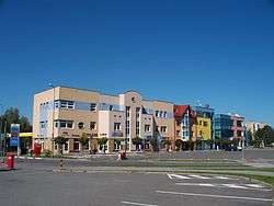
Downtown Orlová-Lutyně | |||
| |||
 Location in the Czech Republic | |||
| Coordinates: 49°50′50″N 18°25′6″E / 49.84722°N 18.41833°E | |||
| Country | Czech Republic | ||
| Region | Moravian-Silesian | ||
| District | Karviná | ||
| First mentioned | 1223 | ||
| Town rights | 1922 | ||
| Town parts | |||
| Government | |||
| • Mayor | Jiří Michalík (ČSSD) | ||
| Area | |||
| • Total | 24.67 km2 (9.53 sq mi) | ||
| Elevation | 215 m (705 ft) | ||
| Population (2012) | |||
| • Total | 30,988 | ||
| • Density | 1,300/km2 (3,300/sq mi) | ||
| Postal code | 735 11 to 735 14 | ||
| Website | http://www.mesto-orlova.cz/ | ||
Orlová (Czech pronunciation: [ˈorlovaː]; Polish: Orłowa ; German: Orlau) is a town in the Karviná District, Moravian-Silesian Region, Czech Republic. It lies in the historical region of Cieszyn Silesia.
The name is most probably possessive in origin, derived from the personal name Orel (Czech) (Orzeł in Polish), the same as eagle in English, although it may also be of topographic origins.[1]
History
According to legend, Mieszko, a Silesian duke from the lower branch of the Piast dynasty, went hunting with his pregnant wife, Ludmiła. As they rested upon a hill, an eagle suddenly took flight, frightening the couple. The eagle dropped his prey, which fell to earth near them. Ludmiła prematurely gave birth to her child, Kazimierz. The couple, seeing a sign from God in this incident, founded a chapel on that spot and later named the subsequent settlement after the eagle (Polish: orzeł, Czech: orel). Thus, it is not clear when the settlement was really founded; however, it was first mentioned in a document of Pope Gregory IX issued on 7 December 1227 for Benedictine abbey in Tyniec as Orlova.[2] Around 1268 a separate but dependent from Tyniec Benedictine monastery was founded.[3]
Politically it belonged then to the Duchy of Opole and Racibórz and the Castellany of Cieszyn, which was in 1290 formed in the process of feudal fragmentation of Poland into the Duchy of Teschen, ruled by a local branch of Silesian Piast dynasty. In 1327 the duchy became a fee of the Kingdom of Bohemia, which after 1526 became a part of the Habsburg Monarchy.
During the Middle Ages it was a settlement of agricultural character. Major change came in the 19th century with the coal mining boom. The population grew rapidly together with urban development.
After the Revolutions of 1848 in the Austrian Empire, a modern municipal division was introduced in the re-established Austrian Silesia. The village as a municipality was subscribed at least since 1880 to political district and legal district of Freistadt. In 1908 the municipality gained market town rights.
At the beginning of the 20th century Orlová became an important center of Polish and Czech education and home to many cultural and sport organizations of both communities. There were also a Jewish and a German community in the town.
According to the censuses conducted in 1880, 1890, 1900 and 1910 the population of the municipality grew from 2,955 in 1880 to 8,334 in 1910. The dominant language spoken colloquially was alternating through the censuses. In 1880 and 1900 the majority were Polish-speakers (2,287 or 79.8% in 1880 and 3.919 or 60.3% in 1900), whereas in 1890 and 1910 the majority were Czech-speakers (2.199 or 65.8% in 1890 and 4.799 or 58.5% in 1910). They were accompanied by a German-speaking minority (at least 4.7% in 1890, at most 7.3% in 1910). In terms of religion, in 1910 the majority were Roman Catholics (6,140 or 73.6%), followed by Protestants (1,801 or 21.6%), Jews (374 or 4.5%) and others (19 or 0.3%).[4] The village was also traditionally inhabited by Silesian Lachs, speaking Cieszyn Silesian dialect, additionally industrial growth lured a large influx of migrant workers, mostly from western Galicia.
After World War I, fall of Austria-Hungary, Polish–Czechoslovak War and the division of Cieszyn Silesia in 1920, Orlová became a part of Czechoslovakia. Orlová gained town rights in 1922. During the workers' strike in 1925 four workers were killed by the police. Following the Munich Agreement, in October 1938 together with the Zaolzie region it was annexed by Poland, administratively organised in Frysztat County of Silesian Voivodeship.[5] The village was then annexed by Nazi Germany at the beginning of World War II. After the war it was restored to Czechoslovakia. In 1946 the villages of Lazy (Łazy), Poruba (Poręba) and Horní Lutyně were administratively joined to the town. Widespread coal mining, especially during the communist era, had a devastating impact on the town, its buildings and architecture, especially in Lazy. Many buildings in Orlová were demolished, including the Polish grammar school built in 1909. The architectural character of the town was completely changed.
Landmarks
The most important landmark in Orlová is the Neo-Gothic church, which replaced an older wooden one. It was almost completely rebuilt in 1903–1906, when it became the dominant edifice of the town. An important feature of the church is the stair leading up to it. The church was damaged by extensive coal mining in the town and the surroundings, and renovation work began in the 1990s and still continues. Another notable landmark is the town hall from 1928. There is also a Lutheran church in the town, consecrated in 1862.
Education
There are several primary schools in Orlová, mostly Czech, one Polish. Several high schools are located there. Most notable is a Czech gymnasium which was rebuilt in modern architectural style and opened in 1996.

Sport
Cycling
Orlová organises annually an women's cycle stage race called Gracia-Orlová and hosted the final stage of the 2012 and 2013 Gracia-Orlová.
Notable residents and natives
- Radim Uzel, czech sexulogist
- Józef Berger, Polish theologian and politician
- Emanuel Chobot, Polish politician
- Adolf Fierla, Polish poet
- Martina Janková, opera singer
- Stanislav Kolíbal, Czech artist and sculptor
Sister towns
Footsteps
- ↑ Mrózek, Robert (1984). Nazwy miejscowe dawnego Śląska Cieszyńskiego [Local names of former Cieszyn Silesia] (in Polish). Katowice: Uniwersytet Śląski w Katowicach. p. 132. ISSN 0208-6336.
- ↑ Panic, Idzi (2010). Śląsk Cieszyński w średniowieczu (do 1528) [Cieszyn Silesia in the Middle Ages (until 1528)] (in Polish). Cieszyn: Starostwo Powiatowe w Cieszynie. p. 286. ISBN 978-83-926929-3-5.
- ↑ I. Panic, 2010, p. 428
- ↑ Piątkowski, Kazimierz (1918). Stosunki narodowościowe w Księstwie Cieszyńskiem (in Polish). Cieszyn: Macierz Szkolna Księstwa Cieszyńskiego. pp. 273, 290.
- ↑ "Ustawa z dnia 27 października 1938 r. o podziale administracyjnym i tymczasowej organizacji administracji na obszarze Ziem Odzyskanych Śląska Cieszyńskiego". Dziennik Ustaw Śląskich (in Polish). Katowice. nr 18/1938, poz. 35. 31 October 1938. Retrieved 1 July 2014.
References
- Radłowska-Obrusnik, Martyna (2007-12-22). "Kamienny szept historii". Głos Ludu. p. 10.
External links
- (Czech) Official website
| Wikimedia Commons has media related to Orlová. |
Coordinates: 49°50′50″N 18°25′6″E / 49.84722°N 18.41833°E


