Raystown Branch Juniata River

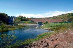
Raystown Lake Dam on the Raystown Branch Juniata River
The Raystown Branch Juniata River is the largest and longest tributary of the Juniata River in south-central Pennsylvania in the United States.[1]
The Raystown Branch Juniata River begins along the Allegheny Front in Somerset County and flows 123 miles (198 km) to the confluence with the Juniata River near Huntingdon.[2] It passes through the boroughs of Bedford and Everett along its course.
Approximately 5.4 miles (8.7 km) upstream of the mouth, the United States Army Corps of Engineers Raystown Dam forms Raystown Lake, the largest lake in Pennsylvania.[1]
Bridges
- The Diehls Covered Bridge crosses Raystown Branch Juniata River in Harrison Township, Pennsylvania.[3]
- The Bridge in Snake Spring Township crosses Raystown Branch Juniata River in Snake Spring Township, Pennsylvania.[4]
- The Corbin Bridge crosses Raystown Branch Juniata River in Juniata Township, Pennsylvania.[5]
Tributaries
(Heading downstream)
- Breastwork Run
- Dunning Creek
- Cove Creek
- Bloody Run
- Brush Creek
- Yellow Creek
- Great Trough Creek
See also
- List of rivers of Pennsylvania
- Shawnee State Park (Pennsylvania)
- Warriors Path State Park
- Trough Creek State Park
- Bloody Run Canoe Classic
- The Narrows (Pennsylvania)
References
- 1 2 Gertler, Edward. Keystone Canoeing, Seneca Press, 2004. ISBN 0-9749692-0-6
- ↑ U.S. Geological Survey. National Hydrography Dataset high-resolution flowline data. The National Map, accessed August 8, 2011
- ↑ "National Historic Landmarks & National Register of Historic Places in Pennsylvania" (Searchable database). CRGIS: Cultural Resources Geographic Information System. Note: This includes Susan M. Zacher (December 1977). "National Register of Historic Places Inventory Nomination Form: Diehls Covered Bridge" (PDF). Retrieved 2011-11-19.
- ↑ "National Historic Landmarks & National Register of Historic Places in Pennsylvania" (Searchable database). CRGIS: Cultural Resources Geographic Information System. Note: This includes J. Dain Davis (September 1982). "National Register of Historic Places Inventory Nomination Form: Bridge in Snake Spring Township" (PDF). Retrieved 2011-11-19.
- ↑ "National Historic Landmarks & National Register of Historic Places in Pennsylvania" (Searchable database). CRGIS: Cultural Resources Geographic Information System. Note: This includes Deborah L. Suciu (September 1989). "National Register of Historic Places Inventory Nomination Form: Corbin Bridge" (PDF). Retrieved 2011-11-05.
External links
| Wikimedia Commons has media related to Raystown Branch Juniata River. |
Coordinates: 40°26′26″N 77°59′01″W / 40.44054°N 77.98353°W
This article is issued from Wikipedia - version of the 9/11/2016. The text is available under the Creative Commons Attribution/Share Alike but additional terms may apply for the media files.


