Reading Festival Bridge
| Reading Festival Bridge | |
|---|---|
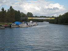
 Reading Festival Bridge in 2008 | |
| Crosses | River Thames |
| Locale | Reading |
| Characteristics | |
| Height | 10 metres (33 ft) |
| Number of spans | 1 |
| History | |
| Construction cost | £1 million |
The Reading Festival Bridge is an occasionally present footbridge over the River Thames at Reading in the English county of Berkshire. When present, the bridge links the site of the Reading Festival, on the south bank of the river, with camp sites and car parking on the north bank. The bridge is within the security perimeter of the festival, and is only available for use by festival goers.[1]
The bridge structure is a temporary construction, erected on permanent footings, and was first erected to serve visitors to the Reading Festival in 2008 at an initial cost of £1 million. The intention was that the bridge would be dismantled and stored for most of the year, being re-erected for future festivals. It replaced a ferry service operated in previous years, which caused complaints over excessive queues.[1][2]
The bridge crosses the river from the western end of the main festival site, some 200 m (660 ft) east of Scours Lane and within the Borough of Reading. The northern end of the bridge lies in the Oxfordshire civil parish of Mapledurham, on land leased from the Mapledurham Estate. Like the main festival site, the northern camp site and car park is used as farmland for most of the year.
In 2009, a wider bridge with improved aesthetics was constructed. The construction sequence of the 2009 bridge also resulted in less disruption to river traffic. Only a single two-hour river closure order was required when installing the bridge, and similarly when removing it. All construction work was carried out at the bridge site, rather than upstream on the Mapledurham estate.
See also
References
- 1 2 "Reading festival bridge to open". BBC. 2008-08-17. Retrieved 2008-08-18.
- ↑ "New bridge for music festival fans". Associated Press. Retrieved 2008-08-18.
| Next crossing upstream | River Thames | Next crossing downstream |
| Whitchurch Bridge (road; toll) | Reading Festival Bridge Grid reference: SU686747 |
Caversham Bridge (road) |
Coordinates: 51°28′02″N 1°00′43″W / 51.467149°N 1.012008°W