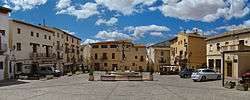
Requena, Valencia
| Requena | ||
|---|---|---|
| Municipality | ||
 | ||
| ||
 Requena Location in Spain | ||
| Coordinates: 39°29′10″N 1°6′6″W / 39.48611°N 1.10167°WCoordinates: 39°29′10″N 1°6′6″W / 39.48611°N 1.10167°W | ||
| Country |
| |
| Autonomous community |
| |
| Province | Valencia | |
| Comarca | Requena-Utiel | |
| Judicial district | Requena | |
| Founded | 7th century BC | |
| Government | ||
| • Alcalde | Javier Berasaluce Ramos (2011) (PP) | |
| Area | ||
| • Total | 814.2 km2 (314.4 sq mi) | |
| Elevation | 692 m (2,270 ft) | |
| Population (2008) | ||
| • Total | 20,807 | |
| • Density | 26/km2 (66/sq mi) | |
| Demonym(s) | Requenense | |
| Time zone | CET (UTC+1) | |
| • Summer (DST) | CEST (UTC+2) | |
| Postal code | 46340 | |
| Official language(s) | Spanish | |
| Website | Official website | |
Requena is a municipality in eastern Spain, in the province of Valencia, located on the left bank of the river Magro.
The town used to be a Moorish fortress, occupying a strong position in the mountainous region of Las Cabrillas (1000 metres). It is dominated by the ancient citadel of the Moors, and still has traces of the original town walls. There are three ancient parish churches; San Nicolas, the oldest, dates from the 13th century, but was partly restored in 1727. Near the town are the sulphurous springs of Fuentepodrida.
List of settlements included in the municipality
- Barrio Arroyo
- Casas de Eufemia
- Casas de Sotos
- El Azagador
- El Pontón
- Fuen Vich
- Hortunas
- La Portera
- Los Ruices
- Los Isidros
- Penén de Albosa
External links
References
 This article incorporates text from a publication now in the public domain: Chisholm, Hugh, ed. (1911). "article name needed". Encyclopædia Britannica (11th ed.). Cambridge University Press.
This article is issued from Wikipedia - version of the 9/11/2016. The text is available under the Creative Commons Attribution/Share Alike but additional terms may apply for the media files.
.svg.png)