Quebec Route 344
| ||||
|---|---|---|---|---|
 | ||||
| Route information | ||||
| Maintained by Transports Québec | ||||
| Length: | 130.5 km[1] (81.1 mi) | |||
| Major junctions | ||||
| West end: |
| |||
|
| ||||
| East end: |
| |||
| Location | ||||
| Major cities: | Oka, Pointe-Calumet, Deux-Montagnes, Saint-Eustache, Boisbriand, Bois-des-Filion, Terrebonne, Charlemagne, Repentigny, L'Assomption | |||
| Highway system | ||||
| ||||

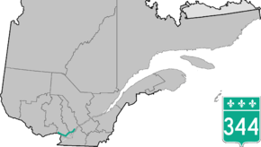
Route 344 is an east/west highway on the north shore of the Ottawa River in Quebec, Canada. Its western terminus is in Grenville-sur-la-Rouge at the junction of Autoroute 50, and its eastern terminus is in L'Assomption at the junction of Route 343. It follows the Ottawa River from Grenville-sur-la-Rouge to Saint-André-d'Argenteuil, where it follows the Lac des Deux Montagnes until Deux-Montagnes, where it follows the Rivière des Mille Îles until Repentigny, where it follows the Rivière l'Assomption until L'Assomption.
Municipalities along Route 344
- Grenville-sur-la-Rouge
- Grenville
- Brownsburg-Chatham
- Saint-André-d'Argenteuil
- Saint-Placide
- Kanesatake
- Oka
- Saint-Joseph-du-Lac
- Pointe-Calumet
- Sainte-Marthe-sur-le-Lac
- Deux-Montagnes
- Saint-Eustache
- Boisbriand
- Rosemère
- Lorraine
- Bois-des-Filion
- Terrebonne
- Charlemagne
- Repentigny (Le Gardeur)
- L'Assomption
See also
References
- ↑ Ministère des transports, "Distances routières", page 99-100, Les Publications du Québec, 2005
External links
| Wikimedia Commons has media related to Quebec Route 344. |
- Provincial Route Map (Courtesy of the Quebec Ministry of Transportation) (French)
- Route 344 on Google Maps
This article is issued from Wikipedia - version of the 11/9/2016. The text is available under the Creative Commons Attribution/Share Alike but additional terms may apply for the media files.