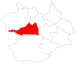
São Valentim, Santa Maria
For the district where is settled this bairro, see São Valentim, district of Santa Maria.
| São Valentim | |
|---|---|
| Bairro | |
 The bairro in District of São Valentim | |
 District of São Valentim, in Santa Maria City, Rio Grande do Sul, Brazil | |
| Coordinates: 29°45′04.65″S 53°53′43.61″W / 29.7512917°S 53.8954472°WCoordinates: 29°45′04.65″S 53°53′43.61″W / 29.7512917°S 53.8954472°W | |
| Country | Brasil |
| State | Rio Grande do Sul |
| Municipality/City | Santa Maria |
| District | District of São Valentim |
| Area | |
| • Total | 133.3800 km2 (51.4983 sq mi) |
| Population [1] | |
| • Total | 565 |
| • Density | 4.2/km2 (11/sq mi) |
| Adjacent bairros | Boca do Monte, Boi Morto, Lorenzi, Pains, Renascença, Santa Flora, Tancredo Neves, Urlândia. |
| Website | Official site of Santa Maria |
São Valentim[2] (Portuguese pronunciation: [ˈsãw valẽˈtĩ], "Saint Valentine") is a bairro in the District of São Valentim in the municipality of Santa Maria, in the Brazilian state of Rio Grande do Sul. It is situated in south of Santa Maria.
Villages
The bairro contains the following villages: Alto das Palmeiras, Área Militar, Capão do Piquenique, Colônia Conceição, Colônia Toniolo, Laranjeiras, Passo da Laranjeira, Passo do Sarandi, Picadinha, Rincão da Lagoa, Rincão dos Brasil, Rincão dos Flores, São Valentim, Vila São Valentim.
Gallery of photos
 |
Boca do Monte | Boca do Monte | Tancredo Neves Boi Morto / Renascença |
 |
| Dilermando de Aguiar | |
Lorenzi Urlândia Pains | ||
| ||||
| | ||||
| Dilermando de Aguiar | Santa Flora | Pains Santa Flora |
References
This article is issued from Wikipedia - version of the 12/28/2014. The text is available under the Creative Commons Attribution/Share Alike but additional terms may apply for the media files.