Samboan, Cebu
| Samboan | |
|---|---|
| Municipality | |
|
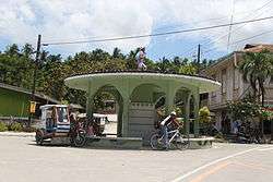
Rotunda, Samboan | |
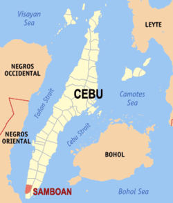
 Map of Cebu with Samboan highlighted | |
.svg.png) Samboan Location within the Philippines | |
| Coordinates: 9°32′N 123°18′E / 9.53°N 123.3°ECoordinates: 9°32′N 123°18′E / 9.53°N 123.3°E | |
| Country | Philippines |
| Region | Central Visayas (Region VII) |
| Province | Cebu |
| District | 2nd district of Cebu |
| Barangay | 15 (see § Barangays) |
| Government [1] | |
| • Type | Sangguniang Bayan |
| • Mayor | Emerito Calderon (LP) |
| • Vice mayor | Emerito Calderon Jr |
| • Town Council |
Members
|
| • Representative | Wilfredo Caminero |
| Area[2] | |
| • Total | 45.16 km2 (17.44 sq mi) |
| Population (2015 census)[3] | |
| • Total | 20,884 |
| • Density | 460/km2 (1,200/sq mi) |
| • Voter (2016)[4] | 12,577 |
| Time zone | PST (UTC+8) |
| ZIP code | 6027 |
| IDD : area code | +63 (0)32 |
| Income class | 5th class |
| PSGC | 072240000 |
| Website |
elgu |
Samboan is a 5th municipal income class municipality in the province of Cebu, Philippines,[2] 150 kilometres (93 mi) south of Cebu City. According to the 2015 census, it has a population of 20,884.[3] In the 2016 election, it had 12,577 registered voters.[4]
History
Samboan is an abbreviation of the word sinamboang, which was a ritual dance performed by the people of the village.
Samboan is a small town on a hill. But it used to be a much bigger town, with Oslob and Alegria under its territorial jurisdiction. In fact, people of Alegria were made to render forced labor for the construction of the Samboan church. It was only some time during the middle of the 1880s that those two towns were separated from Samboan (the towns of Ginatilan and Malabuyoc, which now lie in between, were created after the separation).
Barangays
Samboan comprises 15 barangays:[2]
| PSGC | Barangay | Population | ±% p.a. | ||
|---|---|---|---|---|---|
| 2015[3] | 2010[5] | ||||
| 072240001 | Basak | 5.1% | 1,064 | 1,027 | +0.68% |
| 072240002 | Bonbon | 2.9% | 608 | 540 | +2.28% |
| 072240003 | Bulangsuran | 5.4% | 1,121 | 1,099 | +0.38% |
| 072240004 | Calatagan | 6.6% | 1,371 | 1,126 | +3.82% |
| 072240005 | Cambigong | 3.7% | 782 | 670 | +2.99% |
| 072240010 | Camburoy | 3.8% | 802 | 870 | −1.54% |
| 072240006 | Canorong | 5.2% | 1,085 | 926 | +3.06% |
| 072240007 | Colase | 5.2% | 1,086 | 968 | +2.21% |
| 072240008 | Dalahikan | 6.6% | 1,379 | 1,185 | +2.93% |
| 072240009 | Jumangpas | 7.3% | 1,517 | 1,400 | +1.54% |
| 072240015 | Monteverde | 3.5% | 734 | 720 | +0.37% |
| 072240011 | Poblacion | 18.8% | 3,928 | 3,901 | +0.13% |
| 072240012 | San Sebastian | 10.5% | 2,197 | 2,167 | +0.26% |
| 072240013 | Suba | 9.3% | 1,948 | 952 | +14.61% |
| 072240014 | Tangbo | 6.0% | 1,262 | 1,080 | +3.01% |
| Total | 20,884 | 18,613 | +2.22% | ||
Demographics
| Population census of Samboan | |||||||||||||||||||||||||
|---|---|---|---|---|---|---|---|---|---|---|---|---|---|---|---|---|---|---|---|---|---|---|---|---|---|
|
| ||||||||||||||||||||||||
| Source: Philippine Statistics Office[3][5][6] | |||||||||||||||||||||||||
In the 2016 election, it had 12,577 registered voters, meaning that 60% of the population are aged 18 and over.[4]
Culture
Heritage buildings
One aspect of interest is that of Samboan's cultural heritage left by the Spanish conquerors. St. Michael Archangel Church is one of the oldest Spanish-built churches in Cebu, with its façade made of coral stones.
The Watch Tower is another Spanish structure, also made up of blocks of coral stones. It was built on the side of the hill to watch out for Moro invaders approaching the island. It is the tallest watch tower in the entire island of Cebu, and best preserved.
Connecting the beach area with the Spanish Watch Tower is St. Jacob's Ladder (Escala de Jacobe). It is a flight of 147 stone steps built in 1878, which leads to the old watchtower on a plateau 65 metres (213 ft) above the town. From here, one can get a view of the Tañon Strait.
The Samboan WWII Volunteers Monument, at the center of Poblacion on the National Highway, was built in honor of the many volunteers who fought for the freedom of the Philippines.
The San Sebastian Stone Walls are old stone structures near San Sebastian Parish Church. This may be why this barangay is popularly known as 'Bato' (meaning "stone").
Another Spanish structure is an old coral stone believed to be a Spanish Boundary Post. It stands along the highway in Tangbo beside the Tangbo—Bonbon River Bridge. It was believed that it used to mark the boundary limit of old poblacion but now merely serves to mark the boundary between Bonbon and Tangbo barangays.
Attractions

Samboan is known for its beautiful crystal clear waters with a rich marine ecosystem along its coastal barangays.
Colase Marine Sanctuary is managed by the municipality together with a fisherfolks organization. Samboan's effort for nature's protection is proven by this marine sanctuary's existence for almost two decades already. You can visit the fish sanctuary or dive for a fee where you can experience the most preserved marine ecosystem where sharks often visit, dolphins play, whales often traverse and all kinds of fish visit the shallowest part of the foreshore unprovoked by man. Aside from Colase, other coastal barangays including San Sebastian (Bato), Dalahikan, Tangbo, Bonbon, Suba and Poblacion offer the same experience generally.
Aguinid Waterfalls in Tangbo comprises five different tiers along Tangbo River. Each tier has a unique waterfall. One can never reach the peak or last waterfall without climbing the limestone walls of each waterfall from the lowest to highest.
Bonbon Hidden Falls to the immediate south of Poblacion which some visitors call the Triple Drop Falls.
Ponong Hidden Lake. It is not actually a lake, but a type of a closed lagoon. Its water is brackish. It is unique in the sense that here is where a certain kind of bird – the "manolong" – dives into its salty waters and stays under for a long time in order to escape the hunters. Also near the Poblacion (town center) at the hilly portion lies Calina‑ay where you can also take a deep swim in the cool lagoon of the…
Balay'g Sawa Falls. Near the Poblacion at the hilly portion lies Calina‑ay where one can plunge into the cool natural water pool. It is a smaller waterfall but has a bigger lagoon for swimming.
Mt. Bartolina situated in between Bulangsuran and Canang (Oslob) is where one can climb the peak and see both sides of Cebu, facing Bohol Strait to the east and Tañon Strait to the west. Bartolina is the highest peak in the south of Cebu where the panoramic view of north and south Bais Bay and the rest of Negros, Siquijor, and Bohol islands can be seen. From there, you can catch both the rising and setting of the sun.
Dau Falls of Suba is a new spot to wander. It is the highest waterfall of Samboan.[7]
Tabon Falls is a recently developed natural spot found between Tangbo and Bonbon.
Town Fiesta
The town fiesta is celebrated each 29–30 September in honor of the patron saint, Michael (San Miguel, ang Arkanghel).
Delicacies
- Torta Espesyal (with or without coco wine) and Samboan cookies, which usually come out best during fiesta for visitors to try.
- Torta de Tangbo is said to be among the best in the locality.
References
- ↑ "Municipality". Quezon City, Philippines: Department of the Interior and Local Government. Retrieved 31 May 2013.
- 1 2 3 "Municipal: Samboan, Cebu". PSGC Interactive. Quezon City, Philippines: Philippine Statistics Authority. Retrieved 8 January 2016.
- 1 2 3 4 "Region VII (CENTRAL VISAYAS)". Census of Population (2015): Total Population by Province, City, Municipality and Barangay (Report). PSA. Retrieved 20 June 2016.
- 1 2 3 "2016 National and Local Elections Statistics". Commission on Elections. 2016.
- 1 2 "Region VII (CENTRAL VISAYAS)". Census of Population and Housing (2010): Total Population by Province, City, Municipality and Barangay (Report). NSO. Retrieved 29 June 2016.
- ↑ "Region VII (CENTRAL VISAYAS)". Census of Population (1995, 2000 and 2007): Total Population by Province, City and Municipality (Report). NSO. Archived from the original on 24 June 2011.
- ↑ Balais 2012.
Sources
- Balais, Harry (2012). "Chasing Waterfalls: Dau Falls". Archived from the original on 31 December 2014. Retrieved 26 August 2016.
External links
 |
Ginatilan |  | ||
| Tañon Strait | |
Oslob | ||
| ||||
| | ||||
| Santander |
