Simo, Finland
| Simo | ||
|---|---|---|
| Municipality | ||
| Simon kunta | ||
|
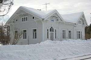
Simo railway station | ||
| ||
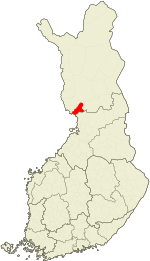
 Location of Simo in Finland | ||
| Coordinates: 65°39.5′N 025°04′E / 65.6583°N 25.067°ECoordinates: 65°39.5′N 025°04′E / 65.6583°N 25.067°E | ||
| Country | Finland | |
| Region | Lapland | |
| Sub-region | Kemi–Tornio sub-region | |
| Charter | 1608/1865 | |
| Government | ||
| • Municipal manager | Esko Tavia | |
| Area (2011-01-01)[1] | ||
| • Total | 2,085.54 km2 (805.23 sq mi) | |
| • Land | 1,445.65 km2 (558.17 sq mi) | |
| • Water | 639.89 km2 (247.06 sq mi) | |
| Area rank | 40th largest in Finland | |
| Population (2016-03-31)[2] | ||
| • Total | 3,220 | |
| • Rank | 227th largest in Finland | |
| • Density | 2.23/km2 (5.8/sq mi) | |
| Population by native language[3] | ||
| • Finnish | 99.5% (official) | |
| • Swedish | 0.1% | |
| • Others | 0.4% | |
| Population by age[4] | ||
| • 0 to 14 | 17.9% | |
| • 15 to 64 | 61.2% | |
| • 65 or older | 20.9% | |
| Time zone | EET (UTC+2) | |
| • Summer (DST) | EEST (UTC+3) | |
| Municipal tax rate[5] | 20.75% | |
| Website | www.simo.fi | |
Simo is a municipality located in the province of Lapland, Finland, about 50 kilometres (30 mi) from the Swedish border.
The municipality has a population of 3,220 (31 March 2016)[2] and covers an area of 2,085.54 square kilometres (805.23 sq mi) of which 639.89 km2 (247.06 sq mi) is water.[1] The population density is 2.23 inhabitants per square kilometre (5.8/sq mi). In 2001, Simo's debt per capita was 946.39 Euros.
Simo's three largest neighbouring towns are Oulu (198,804 inhabitants), Kemi (21,766 inhabitants) and Tornio (22,187 inhabitants). Some of the bigger neighbouring municipalities are Keminmaa (8,383 inhabitants) and Ii (9,689 inhabitants).[2]
History
Early History
The oldest residential areas of Simo are the Simonkylä and Maksniemi regions.[6] The oldest records of human habitation within Simo is found in the village of Simonkylä, which was occupied during the 1300s. In the 1500s the population of Simo began to grow as a result of migration, the population increased especially in the villages of Simonkylä and Simoniemi. Simo was known for its large farms and fishermen.
Development over the course of time
In the 1800s the population gradually began to expand along the beaches of the Simojoki river. In the year of 1865, a large municipal reform occurred in which the municipality, named Simo, received its actual limits, even though the area had long been referred to as Simoksi and the residents simolaisiksi.
Lapland War
During the Lapland War, the village of Maksniemi suffered serious damage. Bridges along the Simojoki river were blown up by the German forces, which is why for quite some time after the war Simojoki had to be crossed by ferry. The destruction of the connection that the bridges provided was important as it cut off the municipality of Simo from Finnish Highway Four.
Landscape
Simo is situated by the Bothnian Bay, at the mouth of river Simojoki. In Simo there is a rural landscape and also in the planning of the centre an attempt has been made to emphasise the nature vicinity. Simo consists of many small and vital village communities. Simo's sights include Simo's Church which was completed in 1846 during the late Empire time and light infantryman place with its statues which will be a memory from the war of independence when the route goes through Simo's wildernesses.
Islands within Simo
Islands within Simo are inclusive of Haahka, Halttari, Harvakari, Härkäletto, Junkiletto, Koivuluoto, Korkiakari, Kuralanletto, Laitakari, Lammasletto, Leipäre, Leipäreenkrunni, Lissabon, Louekari, Montaja, Munakari, Möyly, Oravainen, Paavonletto, Palokarinletto, Paskaletto, Pensasletot, Peurankallio, Pihlajakari, Pikku-Leipäre, Pirttisaari, Rajaletto, Saapaskari, Selkäkari, Selkäkarinmatala, Tiuranen, Tiurasenkalla, Tiurasenkrunni, Tynttyrit, Vatunki, Ykskivi and Ööperit.
School systems
Simo has three elementary schools, one secondary school and a high school. The nearest university is in Oulu.
Industry
In Simo there is no industry. In 2007–2011, Fennovoima considered to build a 1,500 to 2,500 megawatt nuclear power plant[7] in Karsikko and Laitakari.[8] However, Fennovoima announced in October 2011 that the power plant would be built at Pyhäjoki.[9]
Villages
The villages of Simo are inclusive of Alaniemi, Asemakylä, Hamari, Karisuvanto, Koivuoja, Maksniemi, Malininperä, Matala, Ojalanperä, Onkalonperä, Patokoski, Pömiö, Simoniemi, Simonkylä, Siperianperä, Soikko, Taininiemi, Viantie and Ylikärppä.
Notable individuals
- Aarne Orjatsalo, actor
- Esko Tavia, Mayor of Simo from 2002 - 2015
- Juha Marttila, MTK chairman
- Martti Miettunen, Minister of State, three times Prime Minister
- Matti Lackman, Ph.D, principal investigator and philosopher
- Seppo Lohi, Doctor of Theology
- Tuomas Lohi, Mayor of Kempele
- Veikko Huovinen, writer (born in Simo)
References
- 1 2 "Area by municipality as of 1 January 2011" (PDF) (in Finnish and Swedish). Land Survey of Finland. Retrieved 9 March 2011.
- 1 2 3 "Ennakkoväkiluku sukupuolen mukaan alueittain, maaliskuu.2016" (in Finnish). Statistics Finland. Retrieved 31 March 2016.
- ↑ "Population according to language and the number of foreigners and land area km2 by area as of 31 December 2008". Statistics Finland's PX-Web databases. Statistics Finland. Retrieved 29 March 2009.
- ↑ "Population according to age and gender by area as of 31 December 2008". Statistics Finland's PX-Web databases. Statistics Finland. Retrieved 28 April 2009.
- ↑ "List of municipal and parish tax rates in 2011". Tax Administration of Finland. 29 November 2010. Retrieved 13 March 2011.
- ↑ "RKY ι Museovirasto". www.rky.fi. Retrieved 2016-05-03.
- ↑ Reuters report, 11 March 2008
- ↑ Fennovoima press release, 11 March 2008
- ↑ "New nuclear reactor to be built at Pyhäjoki". YLE News. Helsinki: Yleisradio Oy. 5 October 2011. Retrieved 5 October 2011.
External links
![]() Media related to Simo at Wikimedia Commons
Media related to Simo at Wikimedia Commons
- Municipality of Simo – Official website


