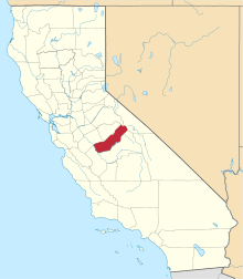
Storey, California
| Storey | |
|---|---|
| Unincorporated community | |
 Storey Location in California | |
| Coordinates: 36°58′27″N 120°01′09″W / 36.97417°N 120.01917°WCoordinates: 36°58′27″N 120°01′09″W / 36.97417°N 120.01917°W | |
| Country | United States |
| State | California |
| County | Madera County |
| Elevation[1] | 289 ft (88 m) |
Storey (formerly, Madera Station)[2] is an unincorporated community in Madera County, California, United States.[1] It is located on the Atchison, Topeka and Santa Fe Railroad (ATSF) 2.5 miles (4 km) east-northeast of Madera,[3] at an elevation of 289 feet (88 m)[1] It is also about 1 mile (1.6 km) southeast of the Fresno River.
The area was named after William Benson Storey, the former president of the ATSF. The former Storey Train Station (used by ATSF, and subsequently by Amtrak), was located in Storey,[4] but Amtrak always referred to the station as Madera.[5][6] The station was permanently closed after Amtrak moved its service to the new Madera station in November 2010. Within a few years thereafter, the station's side platform, uncovered waiting area, and parking lot were entirely removed, leaving little evidence of the former station.
References
- 1 2 3 U.S. Geological Survey Geographic Names Information System: Storey, California
- ↑ Durham, David L (1987). Geographic Names of Madera County California. Fresno, California: Pioneer Publishing. p. 57. Missing or empty
|title=(help) - ↑ Durham, David L. (1998). California's Geographic Names: A Gazetteer of Historic and Modern Names of the State. Clovis, Calif.: Word Dancer Press. ISBN 1-884995-14-4.
- ↑ "Great American Stations: Madera, CA (MDR)". greatamericanstations.com. Amtrak. Retrieved 30 Jun 2014.
- ↑ Amtrak (8 Jan 1978). "Amtrak National Train Timetables". timetables.org. The Museum of Railway Timetables. p. 6. Retrieved 30 Jun 2014.
- ↑ Amtrak (10 May 2010). "Amtrak System Timetables". timetables.org. The Museum of Railway Timetables. p. 15. Retrieved 30 Jun 2014.
