Texas State Highway 19
| ||||
|---|---|---|---|---|
 | ||||
| Route information | ||||
| Maintained by TxDOT | ||||
| Length: | 188.4 mi[1] (303.2 km) | |||
| Existed: | 1917 – present | |||
| Major junctions | ||||
| South end: |
| |||
|
| ||||
| North end: |
| |||
| Highway system | ||||
| ||||

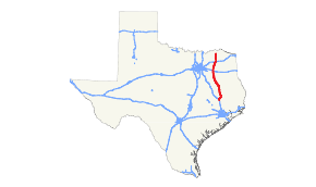
State Highway 19, or SH 19, runs from Huntsville to Paris in east Texas.
Route description
SH 19 begins at an interchange with Interstate 45 in southeast Huntsville. The highway runs through the eastern edge of the town as an expressway running close to the Sam Houston National Forest. The expressway ends at an intersection with State Highway 30 and runs through rural areas before reaching the town of Trinity. SH 19 runs north towards Crockett where the highway begins a concurrency with US 287. The two highways leave each other just northwest of Palestine. SH 19 runs northwest to Athens, running around the town with US 175/State Highway 31. The highway next runs through Canton, where it intersects Interstate 20. SH 19 runs through more rural areas of East Texas until the highway comes to Emory. The highway turns more northeast before running through the western part of Sulphur Springs. State Highway 154 joins SH 19, before leaving just east of Cooper. State Highway 24 joins the highway, where the two highways run together before ending in Paris.
History

SH 19 was one of the original 26 Texas state highways proposed in 1917. The original proposal was for it to run from the Texas/Oklahoma border north of Paris to Houston. By 1922 it had been extended south, with a terminus in Freeport. By 1933, SH 19 was pared back significantly, with the section north of Alba transferred to SH 24 and SH 154. By 1939, the section south of Palestine had been removed, but was extended north back over SH 154 to Sulphur Springs. In 1945, SH 19 was routed over FM 647 from 1 mile south of the Hopkins County Line through Emory to Dunbar. In 1960, it was extended northward to its original starting point of Paris and again to the south to Huntsville, replacing SH 45.

SH 19A was a spur route of SH 19 that was originally planned in 1919, splitting off at Angleton and traveling to Palacios. By 1933, the route had been renumbered as SH 58.
Junction list
| County | Location | mi | km | Destinations | Notes |
|---|---|---|---|---|---|
| Walker | Huntsville | I-45 exit 113. | |||
| North end of expressway | |||||
| Riverside | |||||
| Trinity | | ||||
| Trinity | |||||
| | |||||
| Houston | Lovelady | ||||
| | |||||
| Crockett | |||||
| South end of SH 21 overlap | |||||
| North end of SH 21 overlap; south end of US 287 overlap | |||||
| Latexo | |||||
| | |||||
| | |||||
| Grapeland | |||||
| | |||||
| Anderson | | South end of SH 294 overlap | |||
| Elkhart | North end of SH 294 overlap | ||||
| | |||||
| Palestine | |||||
| South end of US 84 overlap | |||||
| North end of US 84/287 overlap | |||||
| South end of Spur 127 overlap | |||||
| North end of Spur 127 overlap | |||||
| South end of US 79 overlap | |||||
| North end of US 79 overlap; south end of US 287 overlap | |||||
| | North end of US 287 overlap | ||||
| Montalba | |||||
| | |||||
| Bois d'Arc | |||||
| | |||||
| Henderson | | ||||
| | |||||
| Athens | Interchange; south end of Loop 7 overlap | ||||
| Interchange; south end of US 175 overlap | |||||
| Interchange | |||||
| Interchange; south end of SH 31 overlap | |||||
| Interchange; north end of US 175/SH 31/Loop 7 overlap | |||||
| | |||||
| | |||||
| Van Zandt | | ||||
| | |||||
| | |||||
| | |||||
| Canton | |||||
| | |||||
| | |||||
| Rains | | ||||
| Emory | |||||
| | South end of FM 514 overlap | ||||
| | North end of FM 514 overlap | ||||
| Hopkins | | South end of FM 1567 overlap | |||
| | North end of FM 1567 overlap | ||||
| | South end of SH 11 overlap | ||||
| Sulphur Springs | Interchange | ||||
| North end of SH 11 overlap | |||||
| South end of SH 154 overlap | |||||
| | |||||
| | |||||
| Oak Grove | |||||
| Delta | | North end of SH 154 overlap | |||
| | |||||
| | |||||
| | South end of SH 24 overlap | ||||
| | |||||
| | |||||
| Lamar | | ||||
| | |||||
| Paris | |||||
1.000 mi = 1.609 km; 1.000 km = 0.621 mi
| |||||
References
- ↑ Transportation Planning and Programming Division (n.d.). "State Highway No. 19". Highway Designation Files. Texas Department of Transportation.