U.S. Route 76 in Georgia
| ||||
|---|---|---|---|---|
|
Route of US 76 in Georgia in red | ||||
| Route information | ||||
| Maintained by GDOT | ||||
| Length: | 150.7 mi[1] (242.5 km) | |||
| Existed: | 1926 – present | |||
| Major junctions | ||||
| West end: |
| |||
|
| ||||
| East end: |
| |||
| Location | ||||
| Counties: | Catoosa, Whitfield, Murray, Gilmer, Fannin, Union, Towns, Rabun | |||
| Highway system | ||||
| ||||

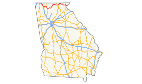
U.S. Route 76 (US 76) is an 150.7-mile-long (242.5 km) east–west U.S. highway in the U.S. state of Georgia. It begins at the Tennessee state line, east of Lakeview, Georgia (and in East Ridge, Tennessee), where the roadway continues concurrent with US-41/SR-8 toward Chattanooga. It ends at the South Carolina state line, where US 76 continues toward Anderson. In Georgia, the highway travels within portions of Catoosa, Whitfield, Murray, Gilmer, Fannin, Union, Towns, and Rabun counties. It travels through North Georgia and connects Ringgold, Dalton, Chatsworth, Ellijay, Blue Ridge, Blairsville, and Clayton. Most of the highway is part of the Lookout Mountain Scenic Highway, a highway that travels through northern Georgia and through the Chattahoochee-Oconee National Forest.
Route description
US 76 traverses the northern part of the state and passes through the Chattahoochee-Oconee National Forest and Georgia's most mountainous region. US 76 passes through Catoosa, Whitfield, Murray, Gilmer, Fannin, Union, Towns, and Rabun counties.
History
1920s
The road that would eventually be designated as US 76 was established at least as early as 1919 as part of SR 3 from the Tennessee state line to Dalton, and SR 2 from Dalton to Clayton, and possibly farther to the east.[2] Georgia's 1921 state map didn't show the Chatsworth–Blairsville segment of SR 2. However, it did show SR 2 on a proposed path from Clayton to Pine Mountain. It also showed SR 65 proposed along the current path of SR 28 from Pine Mountain to the South Carolina state line.[2][3] By the end of 1926, SR 2 was paved from Blue Ridge to a point about halfway between there and Blairsville. Also, the proposed section, east of Clayton, was removed from the map[3][4]
1930s
By the beginning of 1932, SR 3 was paved from the Tennessee state line to Dalton. US 41 was established along this segment. SR 2 was paved from Blairsville to Hiawassee. SR 2 was built from Chatsworth to Ellijay. SR 5 was designated along the Ellijay–Blue Ridge segment.[5][6] In January, SR 2/SR 5 were paved from about Cherry Log to Blue Ridge.[6][7] By August, SR 2 was built from Clayton to the South Carolina state line on its current alignment.[8][9] By January 1935, US 76 was designated along SR 2 from Chatsworth to Blairsville and from just east of Hiawassee to Clayton. It is unclear if US 76 was designated between Blairsville and the Hiawassee area or east of Clayton.[10][11] Between July and October, US 76/SR 2/SR 5 were paved from Ellijay to Cherry Log.[12][13] By October 1936, US 76/SR 2 were paved from Dalton to Chatsworth.[14][15] At the end of the year, there were two small sections of US 76/SR 2 just west of Blairsville and just west of Clayton, that were paved.[15][16] By the middle of January 1938, a very small section, in the vicinity of Lake Burton, was paved.[17][18] The middle of the next year had the section of US 76/SR 2 from the Fanning–Union county line to Blairsville was paved.[19][20] Later that year, a small section of US 76/SR 2, from just east of Lake Burton to Clayton, was paved.[20][21]
1940s
In the beginning of 1940, the paved section near Lake Burton was expanded slightly.[22][23] By October, US 76/SR 2 were paved from east of the location of the current SR 197 intersection to Clayton.[23][24] At the end of the year, US 76/SR 2 were paved from Hiawassee to the approximate location of where the Appalachian Trail crosses the highway today.[24][25] In 1946, US 76 was designated along SR 2 from Dalton to Chatsworth.[26][27] By the middle of 1948, SR 2 was paved from Clayton to about halfway between there and the South Carolina state line.[27][28] The beginning of the next year found US 76 was designated along the section of SR 3 from Ringgold to Dalton. SR 2 was moved to an alignment near the Tennessee state line, traveling through modern-day Varnell and Crandall. SR 52 took its place between Dalton and Ellijay (it already was concurrent with SR 3 from the Ringgold area to Dalton and SR 5 from Ellijay to Blue Ridge). The entire section of US 76/SR 52, from Chatsworth to Ellijay, was paved.[28][29]
1950s to 1980s
By the end of 1950, US 76/SR 2 were paved from Hiawassee to just east of the Towns–Rabun county line. Also, SR 2 was paved from Clayton to the South Carolina state line.[29][30] By the middle of 1954, the entire length of roadway, from Tennessee to South Carolina, was paved.[31][32] 1957 found SR 282 built along the current path of US 76, but only from the Murray–Gilmer county line to Ellijay.[33][34] By 1966, US 76 was designated along US 41/SR 3 from Tennessee to Dalton.[35][36] In 1969, SR 282 was extended west to an intersection with US 411/SR 61 southeast of Ramhurst.[37][38] In 1971, US 76/SR 52 were rerouted west of Chatsworth. Before, they bypassed Spring Place. Northwest of the town, they were routed south into town and entered Chatsworth farther south than it previously did. The former route was redesignated as SR 52 Connector.[39][40] In 1981, US 76 was rerouted between Chatsworth and Ellijay. In Chatsworth, US 76 turned south-southeast, along US 411/SR 61. In Ramhurst, it turned east onto a slightly re-routed SR 282 and followed that route to Ellijay.[41][42] In 1987, US 76/SR 2 between Hemp and Blairsville was routed on a farther-north, and more direct, path.[43][44] In 1989, SR 515 was signed along US 76 from East Ellijay to northeast of Young Harris, as it is today.[45][46]
Major intersections
| County | Location | mi[1] | km | Destinations | Notes | ||
|---|---|---|---|---|---|---|---|
| Catoosa | East Ridge, TN | 0.0 | 0.0 | Tennessee state line | |||
| | 0.7 | 1.1 | |||||
| Ringgold | 6.3 | 10.1 | West end of SR 2 overlap | ||||
| 7.0 | 11.3 | west end of SR 151 overlap | |||||
| 7.8 | 12.6 | east end of SR 151 overlap | |||||
| | 10.2 | 16.4 | East end of SR 2 overlap | ||||
| Sugartown | 11.2 | 18.0 | I-75 exit 345 | ||||
| Whitfield | Tunnel Hill | 15.2 | 24.5 | west end of SR 201 overlap | |||
| Rocky Face | 17.6 | 28.3 | east end of SR 201 overlap | ||||
| Dalton | 20.1 | 32.3 | I-75 exit 336 | ||||
| 22.6 | 36.4 | ||||||
| | 26.1 | 42.0 | east end of US 41 / SR 3 overlap; west end of SR 52 overlap | ||||
| | 27.5 | 44.3 | |||||
| Murray | | 29.6 | 47.6 | ||||
| Chatsworth | 31.3 | 50.4 | |||||
| 34.4 | 55.4 | west end of US 411 / SR 2 / SR 61 overlap | |||||
| 35.8 | 57.6 | East end of SR 2/SR 52 overlap | |||||
| Ramhurst | 41.0 | 66.0 | east end of US 411 / SR 61 overlap; west end of SR 282 overlap | ||||
| | 43.6 | 70.2 | Old Highway 411 | ||||
| Gilmer | East Ellijay | west end of SR 2 overlap | |||||
| 60.9 | 98.0 | east end of SR 282 overlap; west end of SR 5 / SR 515 overlap | |||||
| see SR 515 (mile 24.9-75.0) | |||||||
| Towns | | 111.1 | 178.8 | east end of SR 515 overlap; west end of SR 17 overlap | |||
| Friendship | 113.3 | 182.3 | |||||
| Hiawassee | 115.3 | 185.6 | west end of SR 75 overlap | ||||
| | 118.4 | 190.5 | |||||
| Macedonia | 118.6 | 190.9 | east end of SR 17 / SR 75 overlap | ||||
| Rabun | | 131.4 | 211.5 | ||||
| Clayton | 142.4 | 229.2 | west end of US 23 / US 441 / SR 15 overlap | ||||
| 142.7 | 229.7 | east end of US 23 / US 441 / SR 15 overlap | |||||
| | 150.7 | 242.5 | South Carolina state line | ||||
1.000 mi = 1.609 km; 1.000 km = 0.621 mi
| |||||||
Bannered routes
Ringgold truck route
| |
|---|---|
| Location: | Ringgold, Georgia |
U.S. Route 76 Truck is a short truck detour around a low railroad bridge in Ringgold, Georgia, which is also overlapped by U.S. Route 41 Truck. The route begins at the east end of the overlap with State Route 151 (SR 151) along Tennessee Street, then turns right along High Street (SR 151 Spur), overlapping that route for the rest of its journey. After crossing the aforementioned railroad lines US 41 Truck/76/GA 151 Spur turns right onto Evitt Street, curving around the Catoosa County Fire House near Kittle Street. The fire department property ends across from Vermont Street, and the truck routes finally end at US 41/US 76/SR 2/SR 3.
See also
-
.svg.png) Georgia (U.S. state) portal
Georgia (U.S. state) portal -
 U.S. Roads portal
References
- 1 2 Google (February 16, 2013). "U.S. Route 76 in Georgia" (Map). Google Maps. Google. Retrieved February 16, 2013.
- 1 2 Key Map System of State and Roads (PDF) (Map). Cartography by GSHD. State Highway Department of Georgia. January 1, 1920. Retrieved May 15, 2014.
- 1 2 System of State Roads (PDF) (Map). Cartography by GSHD. State Highway Department of Georgia. September 23, 1921. Retrieved May 15, 2014.
- ↑ System of State Roads (PDF) (Map). Cartography by GSHD. State Highway Department of Georgia. October 1, 1926. Retrieved May 15, 2014.
- ↑ System of State Roads (PDF) (Map). Cartography by GSHD. State Highway Department of Georgia. October 1, 1929. Retrieved May 15, 2014.
- 1 2 System of State Roads (PDF) (Map). Cartography by GSHD. State Highway Department of Georgia. January 1, 1932. Retrieved May 15, 2014.
- ↑ System of State Roads (PDF) (Map). Cartography by GSHD. State Highway Department of Georgia. February 1, 1932. Retrieved May 15, 2014.
- ↑ System of State Roads (PDF) (Map). Cartography by GSHD. State Highway Department of Georgia. May 1, 1932. Retrieved May 15, 2014.
- ↑ System of State Roads (PDF) (Map). Cartography by GSHD. State Highway Department of Georgia. August 1, 1932. Retrieved May 15, 2014.
- ↑ System of State Roads (PDF) (Map). Cartography by GSHD. State Highway Department of Georgia. October 1, 1934. Retrieved May 15, 2014.
- ↑ System of State Roads (PDF) (Map). Cartography by GSHD. State Highway Department of Georgia. January 1, 1935. Retrieved May 15, 2014.
- ↑ System of State Roads (PDF) (Map). Cartography by GSHD. State Highway Department of Georgia. July 1, 1935. Retrieved May 15, 2014.
- ↑ System of State Roads (PDF) (Map). Cartography by GSHD. State Highway Department of Georgia. October 1, 1935. Retrieved May 15, 2014.
- ↑ System of State Roads (PDF) (Map). Cartography by GSHD. State Highway Department of Georgia. July 1, 1936. Retrieved May 15, 2014.
- 1 2 Georgia State Highway Map (PDF) (Map). Cartography by GSHD. State Highway Department of Georgia. October 1, 1936. Retrieved May 15, 2014.
- ↑ System of State Roads (PDF) (Map). Cartography by GSHD. State Highway Department of Georgia. January 1, 1937. Retrieved May 15, 2014.
- ↑ System of State Roads (PDF) (Map). Cartography by GSHD. State Highway Department of Georgia. October 1, 1937. Retrieved May 15, 2014.
- ↑ State of Georgia System of State Roads (PDF) (Map). Cartography by GSHD. State Highway Board of Georgia. January 15, 1938. Retrieved May 15, 2014.
- ↑ System of State Roads (PDF) (Map). Cartography by GSHD. State Highway Department of Georgia. July 1, 1938. Retrieved May 15, 2014.
- 1 2 System of State Roads (PDF) (Map). Cartography by GSHD. State Highway Department of Georgia. July 1, 1939. Retrieved May 15, 2014.
- ↑ System of State Roads (PDF) (Map). Cartography by GSHD. State Highway Department of Georgia. October 1, 1939. Retrieved May 15, 2014.
- ↑ System of State Roads (PDF) (Map). Cartography by GSHD. State Highway Department of Georgia. January 1, 1940. Retrieved May 15, 2014.
- 1 2 System of State Roads (PDF) (Map). Cartography by GSHD. State Highway Department of Georgia. April 1, 1940. Retrieved May 15, 2014.
- 1 2 System of State Roads (PDF) (Map). Cartography by GSHD. State Highway Department of Georgia. October 1, 1940. Retrieved May 15, 2014.
- ↑ System of State Roads (PDF) (Map). Cartography by GSHD. State Highway Department of Georgia. January 1, 1941. Retrieved May 15, 2014.
- ↑ System of State Roads (PDF) (Map). Cartography by GSHD. State Highway Department of Georgia. January 1, 1945. Retrieved May 15, 2014.
- 1 2 State of Georgia System of State Roads (PDF) (Map). Cartography by GSHD. State Highway Department of Georgia. November 7, 1946. Retrieved May 15, 2014.
- 1 2 State of Georgia System of State Roads (PDF) (Map). Cartography by GSHD. State Highway Department of Georgia. February 28, 1948. Retrieved May 15, 2014.
- 1 2 State of Georgia System of State Roads (PDF) (Map). Cartography by GSHD. State Highway Department of Georgia. April 1, 1949. Retrieved May 15, 2014.
- ↑ State of Georgia System of State Roads (PDF) (Map). Cartography by GSHD. State Highway Department of Georgia. August 1, 1950. Retrieved May 15, 2014.
- ↑ State of Georgia System of State Roads (PDF) (Map). Cartography by GSHD. State Highway Department of Georgia. September 1, 1953. Retrieved May 15, 2014.
- ↑ State of Georgia System of State Roads (PDF) (Map). Cartography by GSHD. State Highway Department of Georgia. June 1, 1954. Retrieved May 15, 2014.
- ↑ State of Georgia System of State Roads (PDF) (Map). Cartography by GSHD. State Highway Department of Georgia. June 1, 1955. Retrieved May 15, 2014.
- ↑ State of Georgia System of State Roads (PDF) (Map). Cartography by GSHD. State Highway Department of Georgia. July 1, 1957. Retrieved May 15, 2014.
- ↑ State of Georgia System of State Roads (PDF) (Map). Cartography by GSHD. State Highway Department of Georgia. June 1, 1963. Retrieved May 15, 2014.
- ↑ Georgia State Highway System and Connections (PDF) (Map). Cartography by GSHD. State Highway Department. January 1, 1966. Retrieved May 15, 2014.
- ↑ Official Highway Map (PDF) (Map). Cartography by GSHD. State Highway Department. January 1, 1969. Retrieved May 15, 2014.
- ↑ Official Highway Map (PDF) (Map). Cartography by GSHD. State Highway Department. January 1, 1970. Retrieved May 15, 2014.
- ↑ Official Highway Map (PDF) (Map). Cartography by GSHD. State Highway Department. January 1, 1971. Retrieved May 15, 2014.
- ↑ Official Highway Map (PDF) (Map). Cartography by GSHD. State Highway Department. January 1, 1972. Retrieved May 15, 2014.
- ↑ Official Highway and Transportation Map (PDF) (Map). Cartography by GSHD. Georgia Department of Transportation. March 1, 1980. Retrieved May 15, 2014.
- ↑ Official Highway and Transportation Map (PDF) (Map). Cartography by GSHD. Georgia Department of Transportation. January 1, 1982. Retrieved May 15, 2014.
- ↑ Official Highway and Transportation Map (PDF) (Map). Cartography by GSHD. Georgia Department of Transportation. January 1, 1987. Retrieved May 15, 2014.
- ↑ Official Highway and Transportation Map (PDF) (Map). Cartography by GSHD. Georgia Department of Transportation. January 1, 1988. Retrieved May 15, 2014.
- ↑ Official Highway and Transportation Map (PDF) (Map). Cartography by GSHD. Georgia Department of Transportation. January 1, 1989. Retrieved May 16, 2014.
- ↑ Official Highway and Transportation Map (PDF) (Map). Cartography by GSHD. Georgia Department of Transportation. January 1, 1990. Retrieved May 16, 2014.
External links
 Media related to U.S. Route 76 at Wikimedia Commons
| Previous state: Tennessee |
Georgia | Next state: South Carolina |