West End, Queensland (Townsville)
This article is about the suburb of Townsville, Queensland. For the suburb of Brisbane, Queensland, see West End, Queensland.
| West End Townsville, Queensland | |||||||||||||
|---|---|---|---|---|---|---|---|---|---|---|---|---|---|
| Population | 4,242 (2011 census)[1] | ||||||||||||
| Postcode(s) | 4810 | ||||||||||||
| LGA(s) | City of Townsville | ||||||||||||
| State electorate(s) | Townsville | ||||||||||||
| Federal Division(s) | Herbert | ||||||||||||
| |||||||||||||
West End is one of the older suburbs of Townsville, Queensland, Australia. In the 2011 census, West End had a population of 4,242 people.[1]
Geography
West End is situated at the base of Castle Hill (the hill).
History

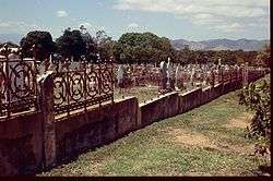
West End Cemetery
The first community cemetery is located in West End. A reflection of attitudes existing during the time it was in use, research has established that it was ethnically segregated. It has been reported that there are separate areas where, at least, Chinese and Aboriginal deceased were interred.
During World War 2, the massive Green Street bunker was used by the RAAF. It is now the State Emergency Service building.
Heritage listings
St_Marys_Townsville.jpg)
St Marys Church, West End
West End has a number of heritage-listed sites, including:
- 5 Castling Street: Currajong (house)[2]
- Francis Street: West End Cemetery[3]
- Green Street: former RAAF Operations Building Site[4]
- 29 Ingham Road: Townsville West State School[5]
- 34 Ingham Road: St Mary's Church & Convent[6]
- 72-104 Ingham Road: Townsville Showground[7]
- 89 Ingham Road: West End Hotel[8]
- 95 Stagpole Street: Wolverton[9]
References
- 1 2 Australian Bureau of Statistics (31 October 2012). "West End". 2011 Census QuickStats. Retrieved 31 January 2016.
- ↑ "Currajong (entry 600884)". Queensland Heritage Register. Queensland Heritage Council. Retrieved 16 July 2013.
- ↑ "West End Cemetery (entry 601475)". Queensland Heritage Register. Queensland Heritage Council. Retrieved 16 July 2013.
- ↑ "RAAF Operations Building Site (former) (entry 602260)". Queensland Heritage Register. Queensland Heritage Council. Retrieved 16 July 2013.
- ↑ "Townsville and District Education Centre and Memorial Gates (entry 602049)". Queensland Heritage Register. Queensland Heritage Council. Retrieved 16 July 2013.
- ↑ "St Mary's Church & former Convent (entry 600879)". Queensland Heritage Register. Queensland Heritage Council. Retrieved 16 July 2013.
- ↑ "Townsville Showground (entry 602650)". Queensland Heritage Register. Queensland Heritage Council. Retrieved 16 July 2013.
- ↑ "West End Hotel (entry 601028)". Queensland Heritage Register. Queensland Heritage Council. Retrieved 16 July 2013.
- ↑ "Wolverton (entry 600927)". Queensland Heritage Register. Queensland Heritage Council. Retrieved 16 July 2013.
External links
Coordinates: 19°15′54″S 146°47′34″E / 19.26500°S 146.79278°E
This article is issued from Wikipedia - version of the 12/2/2016. The text is available under the Creative Commons Attribution/Share Alike but additional terms may apply for the media files.