Wolseong-dong, Gyeongju
| Wolseong-dong | |
|---|---|
| Korean transcription(s) | |
| • Hangul | 월성동 |
| • Hanja | 月城洞 |
| • Revised Romanization | Wolseong-dong |
| • McCune–Reischauer | Wolsongtong |
|
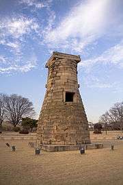
Cheomseongdae located in Wolseong-dong, Gyeongju | |
 | |
| Country | South Korea |
| Region | Gyeongju |
| Government | |
| • Type | Gyeongju City |
| Area | |
| • Total | 31.43 km2 (12.14 sq mi) |
| Population (2008)[1][1] | |
| • Total | 6,269 |
| • Density | 200/km2 (520/sq mi) |
| Dialect | Gyeongsang dialect |
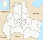
Wolseong-dong is an administrative dong or a neighbourhood in the administrative subdivisions of the Gyeongju City, North Gyeongsang province, South Korea. It consists of nine legal dong including Inwang-dong, Gyo-dong, Dongbang-dong, Doji-dong, Namsan-dong, Pyeong-dong, Guhwang-dong, Bomun-dong and Baeban-dong[1]
It is bordered by Jeongnae-dong and Bodeok-dong on the east, Hwango-dong and Hwangnam-eup on the west, Naenam-myeon on the south and Dongcheon-dong on the north. Its 31.43 square kilometers are home to about 6,269 people. The Gyeongju National Museum, Cheomseongdae, Hwangnyongsa temple site, Gyerim forest, Banwolseong and many cultural and historical sites are situated in the district.[1]
The population is served by two elementary schools and a joint middle-high school.[2]
See also
References
- 1 2 3 4 "월성동 Wolseong-dong 月城洞" (in Korean). Doosan Encyclopedia. Retrieved 2009-08-17.
- ↑ 교육기관 [Educational institution] (in Korean). Gyeongju City. Retrieved 2009-08-17.
External links
Coordinates: 35°04′N 126°49′E / 35.067°N 126.817°E

