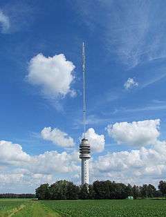
Zendstation Smilde
| Zendstation Smilde | |
|---|---|
 Zendstation Smilde | |
| General information | |
| Status | Partly destroyed - rebuilt |
| Type | Partially guyed tower |
| Location | Smilde, Netherlands |
| Coordinates | 52°54′9.8″N 6°24′12.23″E / 52.902722°N 6.4033972°ECoordinates: 52°54′9.8″N 6°24′12.23″E / 52.902722°N 6.4033972°E |
| Completed | 1959 |
| Destroyed | 15 July 2011 Rebuild was later... |
| Height | 303 m (994.09 ft) |
Zendstation Smilde is a tall partially guyed tower in Hoogersmilde, the Netherlands, built in 1959, for directional radio services and TV and FM-transmissions. The structure is similar to the Gerbrandy Tower (IJsselstein), and consists of an 80 metre high reinforced concrete tower, and until a fire accident on July 15, 2011, had a guyed tubular mast mounted on top. When first built, the tower, including the mast, was 270 metres high. The addition of a further section (analog TV - UHF antenna) to the mast increased its total height to 303.5 m (996 ft). In September 2007 the analog TV - UHF antenna was removed and replaced by a new UHF antenna for DVB-T, reducing the tower's height to 294 m (965 ft). After rebuilding the collapsed tower in 2012, the new height is 303 metres.[1]
Owner
Originally the mast was built by the state company for Post and Telephony (Koninklijke KPN N.V.) but due to privatisation this has changed. Several masts in The Netherlands, including above mentioned Gerbrandy Tower, have a complex ownership structure:[2]
- The 82 m high concrete tower is owned by Alticom BV
- The steel mast on top of the concrete tower is owned by NOVEC BV, a 100% daughter of TenneT BV, which is itself 100% state-owned
- The grounds on which the mast is located is owned by KPN, except for a ring of 3 m around the base of the tower which is owned by Alticom.
Aircraft incident
On 14 August 1968 a US Air Force plane, an F-100 Super Sabre, from the Lakenheath Air Force Base in England was involved in an accident in heavy low clouds where the tip of a wing hit and broke one of the guy-wires of the tower, causing the upper section of the tower to bend. The pilot made an emergency landing at Soesterberg Royal Netherlands Air Force Base with considerable damage to the right wing.[3]
Fire and collapse
On 15 July 2011, the antenna section caught fire and collapsed, leaving only the concrete base standing.[4]
In the above-mentioned report[2] a warning was given that there was an increased risk of accidents in the masts, mainly because of the complex ownership structure and that because of that (safety) processes were unclear. An investigation by the Dutch police didn't show any (criminal) negligence or other factors that could have caused the fire.[5]
Rebuilding the mast
The above fire destroyed the steel mast on top of the concrete tower completely and the top of the concrete tower (the base of the steel mast) was damaged. The owner of the steel mast, NOVEC BV, announced that starting in March 2012, the new mast will be placed on top of the concrete tower and that the new mast will be operational in the summer of 2012. The new mast will be a few metres higher than the destroyed one bringing the mast to the same height as before 2006, and will be a steel lattice construction instead of the original tube style. This will prevent the 'chimney effect', and thus safer in case of a fire.[6] On 14 May 2012, at 10:35 the highest point was reached by the builders of VolkerWessels[7] The mast was fully operational again in October 2012.
See also
References
- ↑ "Zendmast Hoogersmilde bereikt hoogste punt" (in Dutch). VK.nl. 2012-05-14. Retrieved 14 May 2012.
- 1 2 Report Veilig werken op hoog nivo (Working safely at a high level),(Dutch) Chapter 2, published: 8 August 2007, Retrieved 15 February 2012
- ↑ Inspecting damage (31 December 2012)
- ↑ Website Telegraaf Mast TV-transmitter Smilde collapsed Archived July 15, 2011, at the Wayback Machine., 15 July 2011
- ↑ Newssite NU.NL: Geen strafbare feiten bij brand in mast (No criminal offences committed in relation to fire in mast), 20 September 2011. Visited 15 February 2012
- ↑ Website mast-owner NOVEC: Press-releases Archived February 24, 2012, at the Wayback Machine. (Dutch), published 15 February 2012
- ↑ FMTVDX website on Rebuiling mast Hoogersmilde (Dutch), 15 June 2012. Visited 7 July 2012
External links
- Smilde Transmission Tower at Structurae
- Smilde Transmission Tower on fire and collapsing on 15 July 2011 (YouTube video)
- Smilde Transmission Tower on fire and collapsing on 15 July 2011 (YouTube video)
- Rebuiling the mast at Hoogersmilde, continuing story on FM TV DX website
| Wikimedia Commons has media related to Zendstation Smilde. |