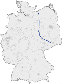
Bundesautobahn 14
| |
|---|---|
| Bundesautobahn 14 | |
 | |
| Route information | |
| Length: | 274 km (170 mi) |
| Location | |
| States: | Mecklenburg-Vorpommern, planned: Brandenburg, Saxony-Anhalt, Saxony |
| Highway system | |
| |

Bundesautobahn 14 (translates from German as Federal Motorway 14, short form Autobahn 14, abbreviated as BAB 14 or A 14) is an autobahn in eastern Germany.
The route comprises two disconnected sections:
- The old A 241. A North-South route in Mecklenburg-Vorpommern which runs from Wismar to Schwerin.
- The original A 14. A West-East route which starts at the A 2 near Magdeburg in Saxony-Anhalt and terminates at the A 4 at Dresden in Saxony. On the way, it serves Halle and Leipzig.
Construction is underway to connect the two sections.
Under construction
- Grabow - Groß Warnow (Opening in 2017).
Exit list
| (1) | Wismar-Ost (inofficial name) | |
| (2) | Wismar 4-way interchange | |
| (3) | Jesendorf | |
| Rest area Pröbbower see | ||
| Mühlenbachtalbrücke 501 m | ||
| Talbrücke Liessow 340 m | ||
| (4) | Schwerin-Nord | |
| Grünbrücke 50 m | ||
| Scheriner See (planned) | ||
| (5) | Schwerin-Ost (later Schwerin-Mitte) | |
| Rest area Plater Berg | ||
| |
Schwerin-Süd (planned) | |
| (7) | Schwerin 4-way interchange | |
| Parking with toilet | ||
| (8) | Ludwigslust-Nord | |
| (9) | Ludwigslust-Süd | |
| |
|
Grabow (under construction) |
| Parking with toilet | ||
| (10) | Groß Warnow | |
| (11) | Karstädt | |
|
| ||
| Rest area (planned) | ||
| |
Wittenberge (planned) | |
| Elbbrücke 1120 m (planned) | ||
| (planned) | ||
| |
Geestgottberg (planned) | |
| |
Seehausen (planned) | |
| |
Osterburg (Altmark) (planned) | |
| (planned) | ||
| |
Uenglingen (planned) | |
| |
Stendal (planned) | |
| (planned) | ||
| |
Lüderitz (planned) | |
| |
Burgstall (planned) | |
| Rest area (planned) | ||
| |
provisional connection (planned) | |
| (20) | Colbitz | |
| Grünbrücke 26 m | ||
| (21) | Wolmirstedt | |
| (planned) | ||
| |
Samswegen (planned) | |
| |
Haldensleben (planned) | |
| Mittellandkanal (planned) | ||
|
| ||
| (1) | Dahlenwarsleben | |
| (2) | Magdeburg 4-way interchange | |
| (3) | Magdeburg-Stadtfeld | |
| Schrotetalbrücke 492 m | ||
| (4) | Wanzleben | |
| (5) | Magdeburg-Sudenburg | |
| Rest area | ||
| (6) | Magdeburg-Reform | |
| Sülzetalbrücke 196 m | ||
| (7) | Schönebeck (Elbe) | |
| Rest area | ||
| (8) | Calbe (Saale) | |
| Bodetalbrücke 326 m | ||
| (9) | Staßfurt | |
| Rest area Strenzfeld | ||
| (10) | Bernburg | |
| (11) | Bernburg 4-way interchange | |
| Wippertalbrücke 452 m | ||
| (12) | Plötzkau | |
| Saalebrücke 805 m | ||
| Rest area Saaleaue | ||
| (13) | Könnern | |
| Services Plötzetal | ||
| Plötzetalbrücke 200 m | ||
| (14) | Löbejün | |
| 3-way interchange Halle-Nord (planned) | ||
| (16) | Halle-Trotha | |
| Götschetalbrücke 731 m | ||
| Rest area | ||
| (17) | Halle-Tornau | |
| (18) | Halle/Peißen | |
| (19) | Halle-Ost extension | |
| Rest area | ||
| Planned to be moved 1 km southeast: | ||
| (20) | Gröbers extension | |
| (21) | Schkeuditzer Kreuz | |
| (22) | Schkeuditz (Flughafen Leipzig/Halle) | |
| (23) | Leipzig-Nord | |
| Rest area Breitenfeld | ||
| (24) | Leipzig-Mitte | |
| (25) | Leipzig-Messegelände | |
| (26) | Leipzig-Nordost | |
| (27) | Leipzig-Ost | |
| (28) | Kleinpösna | |
| (29) | Parthenaue 3-way interchange | |
| (30) | Naunhof | |
| (31) | Klinga | |
| rebuilding to: parking area | ||
| Services Muldental | ||
| (32) | Grimma | |
| Muldebrücke 350 m | ||
| (33) | Mutzschen | |
| parking area | ||
| (34) | Leisnig | |
| Rest area | ||
| Tankstelle Strocken will be removed | ||
| (35) | Döbeln-Nord | |
| (36) | Döbeln-Ost | |
| Raststätte Hansens Holz | ||
| (37) | Nossen-Nord | |
| parking area | ||
| (38) | Nossen-Ost | |
| (39) | Nossen 3-way interchange | |
External links
![]() Media related to Bundesautobahn 14 at Wikimedia Commons
Media related to Bundesautobahn 14 at Wikimedia Commons
This article is issued from Wikipedia - version of the 3/6/2016. The text is available under the Creative Commons Attribution/Share Alike but additional terms may apply for the media files.