Bundesautobahn 99
| |
|---|---|
| Bundesautobahn 99 | |
 | |
| Route information | |
| Length: | 53.5 km (33.2 mi) |
| Location | |
| States: | Bavaria |
| Highway system | |
| |

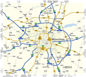
Bundesautobahn 99 (translates from German as Federal Motorway 99, short form Autobahn 99, abbreviated as BAB 99 or A 99) is an autobahn in southern Germany. It is the Munich outer ring road.
History
A ring Autobahn round Munich was planned in 1938,[1] but war intervened and construction was deferred. Sections of the road were constructed to the north and east of the city in the 1960s and 1970s, following a route significantly further from the city centre than the ring planned in the 1930s.[1] In an interview published in 1977 Munich Mayor Georg Kronawitter questioned whether it was necessary ever to close the ring completely.[1] At that stage appeared that a full "closed ring" Autobahn was not in prospect before 2000.[1]
By 2009 further sections to the north and west had been constructed, but the ring was still "incomplete". Building a final section to the south of the city has become a contentious political issue, subject of several politically commissioned studies during the early years of the twenty-first century.
Exit list
| 3-way interchange Oberhaching (planned) | ||
| |
Grünwald (planned) | |
| Tunnel Isartunnel (planned) | ||
| |
Pullach (planned) | |
| Kreuz Forstenrieder Park (planned)
| ||
| |
Gauting (planned) | |
| Tunnel Würmtunnel (planned) | ||
|
| ||
| (4) | München-Südwest 3-way interchange | |
| (5) | München-Freiham-Mitte | |
| (6) | Germering-Nord | |
| Tunnel Aubing 1935 m | ||
| (7) | München-Lochhausen | |
| (8) | München-West 4-way interchange | |
| (9) | München-Allach 3-way interchange | |
| Tunnel Allach 1100 m | ||
| (10) | München-Ludwigsteld | |
| (11) | München-Feldmoching 3-way interchange | |
| Neuherberg parking area | ||
| (12a) | Oberschleißheim-Neuherberg | |
| (12b) | München-Fröttmaning-Nord | |
| (13) | München-Nord 4-way interchange | |
| Isarbrücke 360 m | ||
| Isarkanalbrücke 70 m | ||
| (-) | provisional connection | |
| (14) | Aschheim/Ismaning | |
| Ascheim parking area | ||
| (15) | Kircheim bei München | |
| (16) | München-Ost 4-way interchange | |
| Services Vaterstetten | ||
| (17) | Haar | |
| Putzbrunn parking area | ||
| (18) | Hohenbrunn | |
| (19) | Ottobrunn | |
| (20) | München-Süd 4-way interchange | |
Notes
External links
![]() Media related to Bundesautobahn 99 at Wikimedia Commons
Media related to Bundesautobahn 99 at Wikimedia Commons
Coordinates: 48°05′25″N 11°44′42″E / 48.0903°N 11.745°E