Bundesautobahn 29
| |
|---|---|
| Bundesautobahn 29 | |
 | |
| Route information | |
| Length: | 93 km (58 mi) |
| Major junctions | |
| From: | Wilhelmshaven |
| To: | Oldenburg |
| Location | |
| States: | Lower Saxony |
| Highway system | |
| |
Bundesautobahn 29 (translates from German as Federal Motorway 29, short form Autobahn 29, abbreviated as BAB 29 or A 29) is an autobahn in northwestern Germany. It connects the city of Wilhelmshaven to Oldenburg and the A 1, running very roughly from north to south.
Traffic currently is light, but an increase in freight traffic is to be expected when the JadeWeserPort in Wilhelmshaven becomes operational.
Exit list
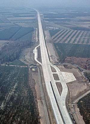
Near Ahlhorn, completed in 1984, sections of motorway were designed to be used as a military runway.
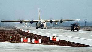
A C-130 Hercules transport plane during a NATO exercise, Highway 84.
| (1) | Niedersachsendamm | |
| (2) | Fedderwardergroden | |
| (3) | Wilhelmshaven | |
| (4) | Fedderwarden | |
| (5) | Wilhelmshavener Kreuz | |
| Ems-Jade-Kanal-Brücke | ||
| (6) | Sande | |
| (7) | Zetel | |
| (8) | Varel / Bockhorn | |
| parking area | ||
| (9) | Varel-Obenstrohe | |
| (10) | Jaderberg | |
| Kreuz Jaderberg (planned) | ||
| Rest area | ||
| (11) | Hahn-Lehmden | |
| (12) | Rastede | |
| (13) | Oldenburg-Nord 4-way interchange | |
| (14) | Oldenburg-Ohmstede (Nordtangente) | |
| Huntebrücke | ||
| (15) | Oldenburg-Hafen | |
| (16) | Oldenburg-Ost 4-way interchange | |
| (17) | Sandkrug | |
| Huntebrücke | ||
| Services Huntetal-West | ||
| Services Huntetal-Ost | ||
| (18) | Wardenburg | |
| (19) | Großenkneten | |
| (20) | Ahlhorn | |
| (21) | Ahlhorner Heide 3-way interchange |
External links
This article is issued from Wikipedia - version of the 12/18/2015. The text is available under the Creative Commons Attribution/Share Alike but additional terms may apply for the media files.