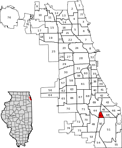
Burnside, Chicago
| Burnside | |
|---|---|
| Community area | |
| Community Area 47 - Burnside | |
 Location within the city of Chicago | |
| Coordinates: 41°43.8′N 87°36′W / 41.7300°N 87.600°WCoordinates: 41°43.8′N 87°36′W / 41.7300°N 87.600°W | |
| Country | United States |
| State | Illinois |
| County | Cook |
| City | Chicago |
| Neighborhoods |
list
|
| Area | |
| • Total | 0.62 sq mi (1.61 km2) |
| Population (2010) | |
| • Total | 2,916 |
| • Density | 4,700/sq mi (1,800/km2) |
| Demographics 2010[1] | |
| • White | 0.65% |
| • Black | 97.7% |
| • Hispanic | 0.69% |
| • Asian | 0.00% |
| • Other | 0.96% |
| Time zone | CST (UTC-6) |
| • Summer (DST) | CDT (UTC-5) |
| ZIP codes | parts of 60619 |
| Median household income | $32,553[2] |
| Source: U.S. Census, Record Information Services | |
Burnside is one of the 77 official community areas of Chicago, Illinois, and is located on the city's south side. This area is also called by locals, "The Triangle", as it is bordered by railroad tracks on every side; the Illinois Central on the west, the Rock Island on the south and the Nickel Plate Railroad (now Norfolk-Southern) on the east.
Originally considered part of Roseland and the Chatham communities, it was distinguished as one of the 77 Chicago communities when the University of Chicago established its official map of Chicago communities. The area was mostly undeveloped swamp land north of Lake Calumet until after the American Civil War. The Illinois Central Railroad (ICRR) built the Burnside Station at 95th street and named it after Ambrose Burnside, a Civil War general and official of the ICRR.
By the 1890s, the ICRR began construction of a roundhouse and repair shop at 95th and South Park Boulevard on what is now the site of Chicago State University. Developer W. V. Jacobs purchased the land in the triangle and began building residential homes. The area was settled by predominantly Hungarian, Polish, Italian and Ukrainian immigrants. Factory jobs were plentiful at the nearby Burnside Shops as well as Pullman Company, Burnside Steel Mill and other nearby factories.
Following World War II, the area's population makeup included a growing number of African-Americans. This was one of several transformations that this working-class neighborhood would undergo. Burnside's fortunes began to change in the 1960s when industry patterns lead to economic decline. Nearby steel mills were shuttered. The Pullman Company scaled back production and eventually closed for good in 1981. Skyrocketing crime rates, gang violence and urban decay forced longtime residents and businesses to move away, a phenomenon referred to as white flight.
References
- ↑ Paral, Rob. "Chicago Demographics Data". Archived from the original on 2 June 2013. Retrieved 12 June 2012.
- ↑ Paral, Rob. "Chicago Census Data". Archived from the original on 5 October 2013. Retrieved 9 October 2012.
External links
 |
Chatham, Chicago | |
Avalon Park, Chicago |  |
| |
Calumet Heights, Chicago | |||
| ||||
| | ||||
| Roseland, Chicago | Pullman, Chicago | South Deering, Chicago |