Courcelles, Quebec
| Courcelles | |
|---|---|
| Municipality | |
|
View of Courcelles' Catholic Church. | |
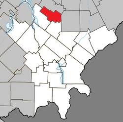
 Location within Le Granit RCM. | |
 Courcelles Location in southern Quebec. | |
| Coordinates: 45°53′15″N 71°00′00″W / 45.88750°N 71.00000°WCoordinates: 45°53′15″N 71°00′00″W / 45.88750°N 71.00000°W[1] | |
| Country |
|
| Province |
|
| Region | Estrie |
| RCM | Le Granit |
| Constituted | April 6, 1904 |
| Government[2] | |
| • Mayor | Mario Quirion |
| • Federal riding | Mégantic—L'Érable |
| • Prov. riding | Beauce-Sud |
| Area[2][3] | |
| • Total | 91.50 km2 (35.33 sq mi) |
| • Land | 90.63 km2 (34.99 sq mi) |
| Population (2011)[3] | |
| • Total | 950 |
| • Density | 10.5/km2 (27/sq mi) |
| • Pop 2006-2011 |
|
| • Dwellings | 466 |
| Postal code(s) | G0M 1C0 |
| Area code(s) | 418 and 581 |
| Highways |
|
| Website |
www muncourcelles |
Courcelles is a municipality in Le Granit Regional County Municipality in the Estrie region in Quebec, Canada. It is approximately 105 km (65 mi) south of Quebec City.
Demographics
In the 2011 Census, Statistics Canada originally reported that Courcelles had a population of 1,004 living in 438 of its 486 total dwellings, an 8.2% change from its 2006 population of 928.[4] Statistics Canada subsequently amended the 2011 census results to a population of 950 living in 418 of its 466 total dwellings, a 2.4% change from 2006.[5] With a land area of 90.63 km2 (34.99 sq mi), it had a population density of 10.48/km2 (27.15/sq mi) in 2011.[4][5]
References
- ↑ Reference number 15531 of the Commission de toponymie du Québec (French)
- 1 2 Geographic code 30090 in the official Répertoire des municipalités (French)
- 1 2 Canada 2011 Census Census Profiles: Courcelles. Statistics Canada.
- 1 2 "Population and dwelling counts, for Canada, provinces and territories, and census subdivisions (municipalities), 2011 and 2006 censuses (Quebec)". Statistics Canada. 2012-02-08. Retrieved 2012-11-11.
- 1 2 "Corrections and updates". Statistics Canada. 2012-10-24. Retrieved 2012-11-11.
 |
Saint-Évariste-de-Forsyth |  | ||
| Lambton | |
Saint-Hilaire-de-Dorset | ||
| ||||
| | ||||
| Saint-Sébastien |
This article is issued from Wikipedia - version of the 10/13/2015. The text is available under the Creative Commons Attribution/Share Alike but additional terms may apply for the media files.
