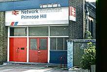
Primrose Hill railway station
| Primrose Hill | |
|---|---|
|
The station in 1986 | |
| Location | |
| Place | Primrose Hill |
| Area | London Borough of Camden |
| Coordinates | 51°32′35″N 0°09′17″W / 51.543179°N 0.154672°WCoordinates: 51°32′35″N 0°09′17″W / 51.543179°N 0.154672°W |
| Grid reference | TQ279843 |
| Operations | |
| Original company | North London Railway |
| Pre-grouping | London and North Western Railway |
| Post-grouping | LMS |
| Platforms | 2 (originally 4) |
| History | |
| 9 June 1851 | Original station opened as Hampstead Road[1] |
| 5 May 1855 | Second station opened due West[1] |
| 1 December 1862 | Renamed as Chalk Farm[1][2] |
| 1 January 1917 | Closed[2] |
| 10 July 1922 | Re-opened[2] |
| 25 September 1950 | Renamed as Primrose Hill[2][3] |
| 28 September 1992 | Closed[3] |
| December 2008 | Platform buildings demolished |
| Disused railway stations in the United Kingdom | |
|
Closed railway stations in Britain A B C D–F G H–J K–L M–O P–R S T–V W–Z | |
|
| |
Primrose Hill was a railway station at Primrose Hill, in the London Borough of Camden, London, England.
It was opened on 5 May 1855 as Hampstead Road,[1] replacing an earlier station of that name (opened 9 June 1851). It was renamed Chalk Farm on 1 December 1862[2] and became Primrose Hill on 25 September 1950.[3] The station closed on 28 September 1992.[3]
History
The station was at the junction of the line west from Camden Road on the North London Line and the West Coast Main Line. There were platforms on both lines; they could be seen from trains using Euston. The platforms serving Euston closed in 1915. The remaining passenger service was, usually peak hours only, between Broad Street and Watford Junction. After Broad Street closed in 1986 the service ran to Liverpool Street, and by the time Primrose Hill station closed only one passenger train a day was using the line.

When the sweep of the North London Line through Hampstead Heath is closed for emergencies or engineering work, the route through Primrose Hill is a viable diversion for North London Line services to access Willesden Junction (Low Level).
The area is served by the nearby Chalk Farm station on the Northern line of the London Underground.

The station building still exists, and is occupied by a shop. It is on Bridge Approach at one end of the pedestrianised bridge over the railway tracks. Nearby is The Roundhouse, an 1847 turntable engine shed, now used as an entertainment venue.
The platform canopies and the buildings supporting them were demolished by Network Rail in December 2008.[4]
Plans

Location of Primrose Hill station | |||||||||||||||||||||||||||||||||||||||||||||||||||||||||||||||||||||||||||||||||||||||||||||||||||||||||||||||||||||||||||||||||||||||||||||||||
|---|---|---|---|---|---|---|---|---|---|---|---|---|---|---|---|---|---|---|---|---|---|---|---|---|---|---|---|---|---|---|---|---|---|---|---|---|---|---|---|---|---|---|---|---|---|---|---|---|---|---|---|---|---|---|---|---|---|---|---|---|---|---|---|---|---|---|---|---|---|---|---|---|---|---|---|---|---|---|---|---|---|---|---|---|---|---|---|---|---|---|---|---|---|---|---|---|---|---|---|---|---|---|---|---|---|---|---|---|---|---|---|---|---|---|---|---|---|---|---|---|---|---|---|---|---|---|---|---|---|---|---|---|---|---|---|---|---|---|---|---|---|---|---|---|---|
Legend
| |||||||||||||||||||||||||||||||||||||||||||||||||||||||||||||||||||||||||||||||||||||||||||||||||||||||||||||||||||||||||||||||||||||||||||||||||
It has been proposed to re-open Primrose Hill station by bringing the short stretch of line between South Hampstead and Camden Road stations back into the regular passenger service by incorporating it into the London Overground network.
| Preceding station | Disused railways | Following station | ||
|---|---|---|---|---|
| Camden Road Line closed, station open |
North London-Watford Link (LNWR suburban system) |
South Hampstead Line closed, station open | ||
See also
- List of closed railway stations in London
- North London Railway
- West Coast Main Line
- London Overground
References
Notes
- 1 2 3 4 Butt (1995), page 113
- 1 2 3 4 5 Butt (1995), page 57
- 1 2 3 4 Butt (1995), page 191
- ↑ "Disused rail station demolished". BBC News. BBC Online. 2009-01-04. Retrieved 2009-01-04.
Network Rail said the buildings had fallen into disrepair and the track was still live so, for safety reasons, they were demolished. Campaigners maintained the station should have been reopened to ease congestion on other lines.
Sources
- Butt, R. V. J. (1995). The Directory of Railway Stations: details every public and private passenger station, halt, platform and stopping place, past and present (1st ed.). Sparkford: Patrick Stephens Ltd. ISBN 1-8526-0508-1. OCLC 60251199.
- Jowett, Alan (March 1989). Jowett's Railway Atlas of Great Britain and Ireland: From Pre-Grouping to the Present Day (1st ed.). Sparkford: Patrick Stephens Ltd. ISBN 1-8526-0086-1. OCLC 22311137.
- Jowett, Alan (2000). Jowett's Nationalised Railway Atlas (1st ed.). Penryn, Cornwall: Atlantic Transport Publishers. ISBN 0-9068-9999-0. OCLC 228266687.
- London's Abandoned Stations - Primrose Hill BR - photos of the station
External links
![]() Media related to Primrose Hill railway station at Wikimedia Commons
Media related to Primrose Hill railway station at Wikimedia Commons

