Headquarters, New Jersey
| Headquarters, New Jersey | |
|---|---|
| Unincorporated community | |
|
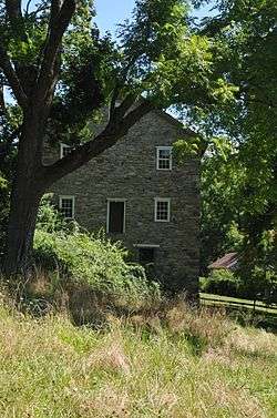
Opdyke Mill | |
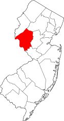
 Headquarters, New Jersey  Headquarters, New Jersey  Headquarters, New Jersey Location of Headquarters in Hunterdon County Inset: Location of county within the state of New Jersey | |
| Coordinates: 40°26′36″N 74°55′23″W / 40.44333°N 74.92306°WCoordinates: 40°26′36″N 74°55′23″W / 40.44333°N 74.92306°W | |
| Country |
|
| State |
|
| County | Hunterdon |
| Township | Delaware |
| Elevation[1] | 276 ft (84 m) |
| Time zone | Eastern (EST) (UTC-5) |
| • Summer (DST) | EDT (UTC-4) |
| GNIS feature ID | 877026[1] |
Headquarters is an unincorporated community located within Delaware Township in Hunterdon County, New Jersey, United States.[2] The settlement is centered around the crossing of Zentek Road over the Caponockons Creek, near the intersection of Zentek Road and Ringoes-Rosemont Road (County Route 604).[3] The area is part of the Headquarters Historic District, a listing on the National Register of Historic Places. Headquarters was the site of a mill established in 1735, one of the first in Hunterdon County. The industry thrived until the early 20th century when the mill shut down. The district was first established as a historic area by Delaware Township in the 1980s to push back against a widening of CR 604. It is now on the national list of historic districts with a renewal of its boundaries occurring in 2016.[4]
References
- 1 2 "Headquarters". Geographic Names Information System. United States Geological Survey.
- ↑ Locality Search, State of New Jersey. Accessed February 28, 2015.
- ↑ Google (September 26, 2016). "Aerial view of Headquarters" (Map). Google Maps. Google. Retrieved September 26, 2016.
- ↑ "National Register of Historic Places Registration Form - Headquarters Boundary Increase" (PDF). United States Department of the Interior - National Park Service. February 8, 2016. Retrieved September 26, 2016.

