Larisons Corners, New Jersey
| Larisons Corners, New Jersey | |
|---|---|
| Unincorporated community | |
|
| |
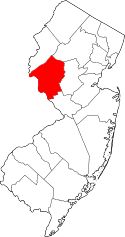
 Larisons Corners, New Jersey  Larisons Corners, New Jersey  Larisons Corners, New Jersey Location of Larisons Corners in Hunterdon County Inset: Location of county within the state of New Jersey | |
| Coordinates: 40°26′29″N 74°51′23″W / 40.44139°N 74.85639°WCoordinates: 40°26′29″N 74°51′23″W / 40.44139°N 74.85639°W | |
| Country |
|
| State |
|
| County | Hunterdon |
| Township | East Amwell and Raritan |
| Elevation[1] | 266 ft (81 m) |
| GNIS feature ID | 877673[1] |
Larisons Corners is an unincorporated community located along the border of East Amwell and Raritan townships in Hunterdon County, New Jersey, United States.[2] Its location is at the corner of Old York Road and where New Jersey Route 30 split from Old York Road and headed north towards Flemington. Today, Old York Road is a part of Route 179 to the southwest and County Route 514/Amwell Road northeast of the point. U.S. Route 202 and Route 31 comprise the main road to Flemington though the highway was built on a new alignment to the south of this point after US 202 bypassed Ringoes in the 1960s.[3] A gas station and some small businesses line US 202 in the area and some churches, Larison's Corner Cemetery, and houses make up the remainder of the area.[3]
History
The settlement was originally called "Pleasant Corner", but was often called Larisons Corner, named for the owner of a hotel located there.
By 1881, a church was located at the settlement, though a blacksmith shop and the Larisons Hotel had ceased operating.[4]
References
- 1 2 "Larisons Corners". Geographic Names Information System. United States Geological Survey.
- ↑ Locality Search, State of New Jersey. Accessed January 31, 2015.
- 1 2 Google (September 20, 2015). "Aerial view of Larisons Corners" (Map). Google Maps. Google. Retrieved September 20, 2015.
- ↑ Snell, James P. (1881). History of Hunterdon and Somerset Counties, New Jersey. Everts & Peck. p. 356.

