Ink, Missouri
| Ink, Missouri | |
|---|---|
| Ghost town | |
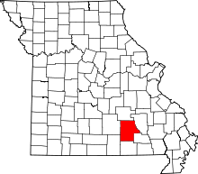
 Ink Location within the state of Missouri | |
| Coordinates: 37°15′29″N 91°29′1″W / 37.25806°N 91.48361°WCoordinates: 37°15′29″N 91°29′1″W / 37.25806°N 91.48361°W | |
| Country | United States |
| State | Missouri |
| County | Shannon |
| Township | Eminence |
| Time zone | Central (CST) (UTC-6) |
| • Summer (DST) | CDT (UTC-5) |
| Area code(s) | 573 |
| GNIS feature ID | 740954[1] |
Ink is a ghost town in Shannon County, Missouri, United States. It is located at the intersection of State Highway 'N' and county road 328. It is near the Sunklands Conservation Area and Alley Spring State Park.
History
According to folklorist Margot Ford McMillen the unusual name of the village came about literally by accident. After several attempts at a name were rejected a community meeting was held. Wanting a name short and memorable, a children's spelling book with three-letter words such as cat, bat, dog, and the like was consulted. The meeting grew lengthy, and finally someone accidentally spilled an ink well onto the book and table. Another citizen suggested "why not call the town Ink?" The U.S. postal authorities found it acceptable, thus the village was officially named.[2]
References
- ↑ U.S. Geological Survey Geographic Names Information System: Ink, Missouri
- ↑ McMillen, Margot Ford (1994). Paris, Tightwad and Peculiar: Missouri Place Names. Columbia, Missouri: University of Missouri Press. p. 5. ISBN 0-8262-0972-6.
