Pennsylvania Route 915
| ||||
|---|---|---|---|---|
 | ||||
| Route information | ||||
| Maintained by PennDOT | ||||
| Length: | 22.2 mi[1] (35.7 km) | |||
| Major junctions | ||||
| South end: |
| |||
|
| ||||
| North end: |
| |||
| Location | ||||
| Counties: | Fulton, Bedford | |||
| Highway system | ||||
| ||||
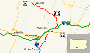
Pennsylvania Route 915 (PA 915) is a 22-mile-long (35 km) state highway located in Fulton and Bedford Counties in Pennsylvania. The southern terminus is at I 70 in Brush Creek Township. The northern terminus is at PA 26 in Hopewell.
Route description
PA 915 begins at an interchange with I-70 in Brush Creek Township, Fulton County, heading northeast on two-lane undivided Crystal Springs Road. The road winds through a mix of farmland and woodland with some homes. At Akersville, the route turns north and winds through more rural areas. PA 915 heads northeast through agricultural areas before turning north and heading into wooded areas with some homes, reaching an intersection with US 30. At this point, the route turns east to form a concurrency with US 30 on Lincoln Highway, heading into Buchanan State Forest. PA 915 splits from US 30 by turning north onto North Valley Road, passing through more of the state forest, passing to the west of Sideling Hill. The road curves to the northeast and passes over I-76 (Pennsylvania Turnpike), crossing into Wells Township. The route winds north through more forests before heading into agricultural areas and turning to the northwest. PA 915 passes through more farmland with some homes, running near Wells Tannery before heading through a mix of farms and woods and passing through a gap in Rays Hill.[2][3]

PA 915 enters Broad Top Township in Bedford County and becomes Sandy Run Road, heading through wooded areas with some homes prior to turning west through a few agricultural clearings with some homes. The road heads across forested Kimber Mountain, curving to the north. The route winds northwest through more forests, passing through Sandy Run and Jerkwater. PA 915 heads west through the community of Langdondale before curving northwest through more woods. The road heads into Hopewell and becomes Water Street, running between the Raystown Branch Juniata River to the west and homes to the east. The route curves northeast onto Front Street and passes through more residential areas. PA 915 crosses the Raystown Branch Juniata River back into Broad Top Township and ends at an intersection with PA 26.[2][4]
Major intersections
| County | Location | mi[1] | km | Destinations | Notes |
|---|---|---|---|---|---|
| Fulton | Brush Creek Township | 0.000 | 0.000 | Exit 151 (I-70) | |
| 6.484 | 10.435 | South end of US 30 overlap | |||
| 7.868 | 12.662 | South end of US 30 overlap | |||
| Bedford | Broad Top Township | 22.163 | 35.668 | ||
| 1.000 mi = 1.609 km; 1.000 km = 0.621 mi | |||||
See also
 U.S. Roads portal
 Pennsylvania portal
References
- 1 2 "Pennsylvania state roads". Pennsylvania Spatial Data Access. Pennsylvania Department of Transportation. 2013. Retrieved March 14, 2013.
- 1 2 Google (June 26, 2011). "overview of Pennsylvania Route 915" (Map). Google Maps. Google. Retrieved June 26, 2011.
- ↑ Fulton County, Pennsylvania Highway Map (PDF) (Map). PennDOT. 2011. Retrieved May 26, 2011.
- ↑ Bedford County, Pennsylvania Highway Map (PDF) (Map). PennDOT. 2011. Retrieved May 20, 2011.
