Texas State Highway 11
| |||||||
|---|---|---|---|---|---|---|---|
 | |||||||
| Route information | |||||||
| Maintained by TxDOT | |||||||
| Length: | 153.2 mi[1] (246.6 km) | ||||||
| Existed: | 1917 – present | ||||||
| Major junctions | |||||||
| West end: |
| ||||||
|
| |||||||
| East end: |
| ||||||
| Location | |||||||
| Counties: | Grayson, Fannin, Hunt, Hopkins, Franklin, Wood, Camp, Titus, Morris, Cass | ||||||
| Highway system | |||||||
| |||||||

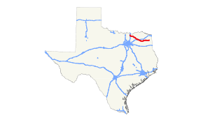
State Highway 11, or SH 11, is a highway that runs from US 59 (Future I-369) in Linden to SH 56 in Sherman in northeast Texas.
Route description
SH 11 begins at an intersection with State Highway 56 on the easternedge of Sherman, just north of the Sherman Regional Airport. The route then travels to the southeast through Northeast Texas. In 2009, it was rerouted around the city of Commerce, concurrent with State Highway 24 and State Loop 178, with the old routing through Commerce transferred to a business route. It continues southeast toward Sulphur Springs, where it shares a concurrency with State Highway 154 and the old routing of US 67, and intersects I-30 on the south side of town. After Sulphur Springs, the route takes a more easterly direction through Northeast Texas, before reaching its eastern terminus at US 59 (Future I-369) on the eastern edge of Linden.
History

State Highway 11 was one of the original twenty-six state highways proposed in 1917, overlaid on top of the 'Jefferson Highway.' In 1917 the routing was proposed from the Oklahoma border at Denison, south on present day U.S. Highway 69 through Whitewright into Greenville. From Greenville, it went east on U.S. Highway 67 to Mount Pleasant, and south on U.S. Highway 271 to Gilmer and along State Highway 300 to Longview, and finally, U.S. Highway 80 through Marshall to the Louisiana border.
In 1919 the segment from Gilmer to Longview had yet to be built, so the road was rerouted over the current US 271 and US 80 routes through Gladewater, Texas.
In 1926 US 67, 271 and 80 were overlaid onto segments of SH 11. While the routes were marked concurrently, by 1926, SH 11 had lost most of its original assignment and had been reassigned to nearby towns the U.S. highways had not reached. The road now began in Greenville where it followed the current SH 11 from to Daingerfield, then north on U.S. Highway 259 through Omaha and terminating in De Kalb. In 1929, SH 11 was rerouted to begin in Ladonia and via the present day State Highway 50 to Commerce and follow the current SH 11 to Sulphur Springs. The section from Greenville to Sulphur Springs became a rerouting of SH 1.
By 1939 the US 259 segment of SH 11 was cancelled, and SH 11 was extended from Daingerfield to Linden via its current alignment, replacing SH 47, and up US 59 to a terminus in Texarkana. The US 59 alignment of SH 11 was removed in 1947, The Ladonia-Commerce segment was removed and replaced with its current assignment in 1971 over FM 1281 and part of FM 697. Part of this was previously designated as Texas State Highway 314.
Major intersections
| County | Location | mi | km | Destinations | Notes | |||
|---|---|---|---|---|---|---|---|---|
| Grayson | Sherman | |||||||
| | ||||||||
| Tom Bean | west end of FM 2729 overlap | |||||||
| east end of FM 2729 overlap | ||||||||
| Whitewright | Western end of US 69 concurrency | |||||||
| | East end of US 69 overlap | |||||||
| Fannin | | |||||||
| | ||||||||
| | interchange | |||||||
| Randolph | Western end of Bus. SH 121 concurrency | |||||||
| Eastern end of Bus. SH 121 concurrency | ||||||||
| | ||||||||
| | ||||||||
| Bailey | ||||||||
| Hunt | Wolfe City | |||||||
| west end of FM 1563 overlap | ||||||||
| west end of FM 1563 overlap | ||||||||
| | ||||||||
| Fairlie | ||||||||
| Commerce | interchange; west end of SH 24 overlap | |||||||
| east end of SH 24 overlap; west end of Loop 178 overlap | ||||||||
| east end of Loop 178 overlap | ||||||||
| Hopkins | | |||||||
| | ||||||||
| Ridgeway | west end of FM 2653 overlap | |||||||
| east end of FM 2653 overlap | ||||||||
| Sulphur Springs | west end of SH 19 overlap | |||||||
| I-30 exit 122 | ||||||||
| Rockdale | east end of SH 19 overlap | |||||||
| Sulphur Springs | ||||||||
| Martin Springs | ||||||||
| | ||||||||
| | ||||||||
| Como | west end of FM 69 overlap | |||||||
| east end of FM 69 overlap | ||||||||
| Pickton | west end of FM 269 overlap | |||||||
| east end of FM 269 overlap | ||||||||
| | ||||||||
| Franklin |
No major junctions | |||||||
| Wood | Winnsboro | west end of FM 852 overlap | ||||||
| east end of FM 852 overlap | ||||||||
| | ||||||||
| | ||||||||
| | ||||||||
| Camp | Leesburg | west end of FM 1519 overlap | ||||||
| east end of FM 1519 overlap | ||||||||
| | ||||||||
| | ||||||||
| | ||||||||
| Pittsburg | ||||||||
| Titus | | |||||||
| | ||||||||
| Morris | Cason | west end of FM 144 overlap | ||||||
| east end of FM 144 overlap | ||||||||
| Daingerfield | west end of US 259 / SH 49 overlap | |||||||
| Eastern end of US 259 concurrency | ||||||||
| | ||||||||
| Cass | Hughes Springs | west end of FM 250 overlap | ||||||
| east end of FM 250 overlap | ||||||||
| Eastern end of SH 49 concurrency | ||||||||
| | ||||||||
| Linden | ||||||||
1.000 mi = 1.609 km; 1.000 km = 0.621 mi
| ||||||||
References
- ↑ Transportation Planning and Programming Division (n.d.). "State Highway No. 11". Highway Designation Files. Texas Department of Transportation. Retrieved 2008-03-15.