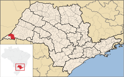
Teodoro Sampaio, São Paulo
| Teodoro Sampaio | |
|---|---|
| Municipality | |
 Location in São Paulo state | |
 Teodoro Sampaio Location in Brazil | |
| Coordinates: 22°31′57″S 52°10′3″W / 22.53250°S 52.16750°WCoordinates: 22°31′57″S 52°10′3″W / 22.53250°S 52.16750°W | |
| Country |
|
| Region | Southeast Region |
| State | São Paulo |
| Area | |
| • Total | 1,556 km2 (601 sq mi) |
| Population (2015) | |
| • Total | 22,675 |
| • Density | 15/km2 (38/sq mi) |
| Time zone | BRT/BRST (UTC-3/-2) |
Teodoro Sampaio is a municipality in the state of São Paulo in Brazil. The population is 22,675 (2015 est.) in an area of 1556 km².[1] The elevation is 321 m.
The municipality contains part of the 246,800 hectares (610,000 acres) Great Pontal Reserve, created in 1942.[2] It contains the 33,845 hectares (83,630 acres) Morro do Diabo State Park, created in 1986.[3] It also contains 36% of the 6,677 hectares (16,500 acres) Mico Leão Preto Ecological Station, established in 2002.[4]
References
- ↑ Instituto Brasileiro de Geografia e Estatística
- ↑ Pontal do Paranapanema (in Portuguese), IBAMA: Instituto Brasileiro do Meio Ambiente e dos Recursos Naturais Renováveis, retrieved 2016-11-13
- ↑ Sobre o Parque (in Portuguese), SAP: Sistema Ambiental Paulista, retrieved 2016-11-07
- ↑ ESEC Mico Leão Preto (in Portuguese), ISA: Instituto Socioambiental, retrieved 2016-09-06
This article is issued from Wikipedia - version of the 11/13/2016. The text is available under the Creative Commons Attribution/Share Alike but additional terms may apply for the media files.