Tidewater, Oregon
| Tidewater, Oregon | |
|---|---|
| Unincorporated community | |
|
Post office in Tidewater | |
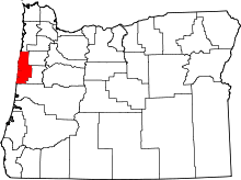
 Tidewater, Oregon  Tidewater, Oregon Location within the state of Oregon | |
| Coordinates: 44°24′40″N 123°54′01″W / 44.41111°N 123.90028°WCoordinates: 44°24′40″N 123°54′01″W / 44.41111°N 123.90028°W | |
| Country | United States |
| State | Oregon |
| County | Lincoln |
| Elevation | 118 ft (36 m) |
| Time zone | PST (UTC-8) |
| • Summer (DST) | PDT (UTC-7) |
| ZIP codes | 97390 |
| Coordinates and elevation from United States Geological Survey[1] | |
Tidewater is an unincorporated community in Lincoln County, Oregon, United States located on the Alsea River east of Waldport on Oregon Route 34.
Tidewater was named because it is near the head of the tide of the Alsea River.[2] Tidewater post office was established in 1878.[2]
Tidewater is the home of White Wolf Sanctuary, a rescue facility for Arctic wolves.[3]
Climate
This region experiences warm (but not hot) and dry summers, with no average monthly high temperatures in Tidewater above 76 °F (24 °C). According to the Köppen Climate Classification system, Tidewater has a warm-summer Mediterranean climate, abbreviated "Csb" on climate maps.[4]
| Climate data for Tidewater | |||||||||||||
|---|---|---|---|---|---|---|---|---|---|---|---|---|---|
| Month | Jan | Feb | Mar | Apr | May | Jun | Jul | Aug | Sep | Oct | Nov | Dec | Year |
| Record high °F (°C) | 68 (20) |
80 (27) |
81 (27) |
92 (33) |
95 (35) |
100 (38) |
106 (41) |
106 (41) |
100 (38) |
93 (34) |
80 (27) |
67 (19) |
106 (41) |
| Average high °F (°C) | 49.5 (9.7) |
54.3 (12.4) |
57 (14) |
61 (16) |
66.1 (18.9) |
70 (21) |
74.6 (23.7) |
75.8 (24.3) |
74.5 (23.6) |
66.2 (19) |
55.5 (13.1) |
49.8 (9.9) |
62.9 (17.2) |
| Average low °F (°C) | 36 (2) |
38 (3) |
38.5 (3.6) |
40.6 (4.8) |
44.4 (6.9) |
48.6 (9.2) |
51.8 (11) |
52.1 (11.2) |
49.7 (9.8) |
45.7 (7.6) |
40.6 (4.8) |
37.4 (3) |
43.6 (6.4) |
| Record low °F (°C) | 8 (−13) |
10 (−12) |
23 (−5) |
26 (−3) |
30 (−1) |
35 (2) |
38 (3) |
40 (4) |
29 (−2) |
25 (−4) |
17 (−8) |
5 (−15) |
5 (−15) |
| Average precipitation inches (mm) | 14.45 (367) |
12.07 (306.6) |
11 (280) |
6.58 (167.1) |
4.12 (104.6) |
2.46 (62.5) |
0.81 (20.6) |
1.12 (28.4) |
2.88 (73.2) |
6.84 (173.7) |
13.48 (342.4) |
15.32 (389.1) |
91.15 (2,315.2) |
| Average snowfall inches (cm) | 1.3 (3.3) |
0.7 (1.8) |
0.1 (0.3) |
0 (0) |
0 (0) |
0 (0) |
0 (0) |
0 (0) |
0 (0) |
0 (0) |
0.1 (0.3) |
0.4 (1) |
2.5 (6.4) |
| Average precipitation days | 20 | 18 | 19 | 16 | 13 | 9 | 4 | 4 | 8 | 13 | 20 | 21 | 165 |
| Source: [5] | |||||||||||||
References
- ↑ "Tidewater". Geographic Names Information System. United States Geological Survey. November 28, 1980. Retrieved September 11, 2009.
- 1 2 McArthur, Lewis A.; Lewis L. McArthur (2003) [1928]. Oregon Geographic Names (Seventh ed.). Portland, Oregon: Oregon Historical Society Press. ISBN 0-87595-277-1.
- ↑ "White Wolf Sanctuary and Educational Facility". White Wolf Sanctuary. Retrieved December 30, 2007.
- ↑ "Tidewater, Oregon". Weatherbase. Canty Media. Retrieved July 23, 2014.
- ↑ "TIDEWATER, OR (358481)". Western Regional Climate Center. Retrieved November 26, 2015.
External links
- Images of the former Tidewater Covered Bridge from Salem Public Library
This article is issued from Wikipedia - version of the 7/30/2016. The text is available under the Creative Commons Attribution/Share Alike but additional terms may apply for the media files.

