Warminster Township, Bucks County, Pennsylvania
| Warminster Township | ||
| Township | ||
|
||
| Country | United States | |
|---|---|---|
| State | Pennsylvania | |
| County | Bucks | |
| Elevation | 312 ft (95.1 m) | |
| Coordinates | 40°12′11″N 75°05′38″W / 40.20306°N 75.09389°WCoordinates: 40°12′11″N 75°05′38″W / 40.20306°N 75.09389°W | |
| Area | 10.2 sq mi (26.4 km2) | |
| - land | 10.2 sq mi (26 km2) | |
| - water | 0.0 sq mi (0 km2), 0% | |
| Population | 32,682 (2010) | |
| Density | 3,061.0/sq mi (1,181.9/km2) | |
| Established | 1685 | |
| Timezone | EST (UTC-5) | |
| - summer (DST) | EDT (UTC-4) | |
| ZIP code | 18974 | |
| Area code | 215, 267 | |
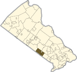
 Location of Warminster Township in Bucks County | ||
|
Location of Warminster Township in Pennsylvania | ||
 Location of Pennsylvania in the United States | ||
| Website: http://www.warminstertownship.org | ||
Warminster Township (aka Warminster) is located in Bucks County, Pennsylvania, United States and was formally established in 1711. It is 3.7 miles northwest of Philadelphia and had a population of 32,682 according to the 2010 U.S. census.[1]
History
The town was called Warminster Township as early as 1685, before its borders were formally established in 1711. It was originally part of Southampton Township, which was founded in 1682 by William Penn.[2] Warminster was named after a small town in the county of Wiltshire, at the western extremity of Salisbury Plain, England.[3] Warminster, Pennsylvania was mostly settled by English and Scotch-Irish after William Penn received a grant of land in the area from King Charles, II.[2]
Warminster began as a small farming community and remained that way throughout most of its history. As recently as 1955, the township had no residential subdivisions and only one housing complex, Lacey Park on Street Road, the site where the Battle of Crooked Billet occurred during the Revolutionary War that resulted in a resounding defeat for George Washington's troops.[2]
Warminster's Craven Hall is included in the National Register of Historic Places listings in Bucks County, Pennsylvania. Warminster's most significant historical figure was William Tennent, an outspoken religious leader and educator.[2]
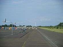
Warminster's Naval Air Warfare Center, previously called the Johnsville Naval Air Development Center and then the Naval Air Development Center, operated from World War II until it closed in 1996. Its site was acquired by the U.S. Navy from the Brewster Aeronautical Corporation in 1943. The Center initially served as a weapons development and airplane testing facility. It then became a training center for the Mercury, Gemini, and Apollo space programs. The facility developed a prototype "black box," best known as the indestructible recorder of cockpit conversations and information in the event of a crash.[4][5]
Geography
Warminster Township is 3.7 miles northwest of Philadelphia at their closest points[6][7] and has a total area of 10.2 square miles (26.5 km²), all of it land. Warminster is drained by the Delaware River tributaries of the Neshaminy Creek and the Pennypack Creek. Its villages include Breadysville (also in Warwick Township,) Casey Highlands, Hartsville (also in Warwick Township,) Johnsville, Rosewood Park, Warminster, and Warminster Heights.
Neighboring municipalities
- Warrington Township (northwest)
- Warwick Township (north)
- Ivyland (northeast)
- Northampton Township (northeast)
- Upper Southampton Township (southeast)
- Upper Moreland Township, Montgomery County (south)
- Hatboro, Montgomery County (southwest)
- Horsham Township, Montgomery County (southwest)
Climate
The climate in this area is characterized by hot, humid summers and generally mild to cool winters. According to the Köppen Climate Classification system, Warminster has a humid subtropical climate, abbreviated "Cfa" on climate maps.[8]
| Climate data for Warminster, Pennsylvania | |||||||||||||
|---|---|---|---|---|---|---|---|---|---|---|---|---|---|
| Month | Jan | Feb | Mar | Apr | May | Jun | Jul | Aug | Sep | Oct | Nov | Dec | Year |
| Record high °F (°C) | 73 (23) |
75 (24) |
85 (29) |
95 (35) |
96 (36) |
99 (37) |
102 (39) |
100 (38) |
102 (39) |
89 (32) |
83 (28) |
75 (24) |
102 (39) |
| Average high °F (°C) | 38.9 (3.8) |
42.1 (5.6) |
51.0 (10.6) |
62.3 (16.8) |
72.1 (22.3) |
80.8 (27.1) |
84.9 (29.4) |
82.9 (28.3) |
75.5 (24.2) |
64.2 (17.9) |
54.3 (12.4) |
42.7 (5.9) |
62.7 (17.1) |
| Average low °F (°C) | 25.5 (−3.6) |
27.6 (−2.4) |
34.0 (1.1) |
43.6 (6.4) |
53.0 (11.7) |
62.5 (16.9) |
67.4 (19.7) |
65.7 (18.7) |
58.0 (14.4) |
46.7 (8.2) |
38.5 (3.6) |
30.0 (−1.1) |
46.1 (7.8) |
| Record low °F (°C) | −9 (−23) |
−6 (−21) |
0 (−18) |
18 (−8) |
29 (−2) |
39 (4) |
49 (9) |
43 (6) |
34 (1) |
25 (−4) |
13 (−11) |
−2 (−19) |
−9 (−23) |
| Average precipitation inches (mm) | 3.6 (91) |
2.8 (71) |
4.2 (107) |
4.0 (102) |
4.2 (107) |
4.1 (104) |
4.9 (124) |
4.1 (104) |
4.7 (119) |
3.5 (89) |
3.8 (97) |
4.3 (109) |
48.2 (1,224) |
| Average snowfall inches (cm) | 8.0 (20.3) |
8.0 (20.3) |
4.5 (11.4) |
0.9 (2.3) |
0 (0) |
0 (0) |
0 (0) |
0 (0) |
0 (0) |
0 (0) |
0.6 (1.5) |
2.7 (6.9) |
24.7 (62.7) |
| Average precipitation days (≥ 0.01 in) | 10.5 | 9.1 | 10.4 | 12.4 | 12.1 | 10.3 | 9.9 | 8.3 | 8.9 | 8.4 | 9.8 | 10.3 | 120.4 |
| Average snowy days (≥ 0.1 in) | 4.0 | 2.4 | 1.6 | 0.5 | 0 | 0 | 0 | 0 | 0 | 0 | 0.4 | 1.7 | 10.6 |
| Average relative humidity (%) | 61.2 | 56.4 | 57.9 | 57.6 | 63.2 | 67.1 | 67.3 | 69.6 | 70.5 | 68.4 | 63.5 | 63.5 | 64.0 |
| Source: Weatherbase [9] | |||||||||||||
Demographics
| Historical population | |||
|---|---|---|---|
| Census | Pop. | %± | |
| 1930 | 1,452 | — | |
| 1940 | 1,977 | 36.2% | |
| 1950 | 7,127 | 260.5% | |
| 1960 | 15,994 | 124.4% | |
| 1970 | 34,900 | 118.2% | |
| 1980 | 35,463 | 1.6% | |
| 1990 | 32,832 | −7.4% | |
| 2000 | 31,383 | −4.4% | |
| 2010 | 32,682 | 4.1% | |
| [10] | |||
As of the 2000 U.S. census:[11]
Warminster Township's residents were 86.0% non-Hispanic white, 7.7% Hispanic or Latino, 3.1% black or African American, 0.2% Native American, 1.9% Asian, 0.1% Native Hawaiian, and 1.8% were two or more races.
The population density was 3,061.0 people per square mile (1,182.2/km²). There were 11,644 housing units at an average density of 1,135.7/sq mi (438.6/km²).
There were 11,350 households, out of which 32.5% had children under the age of 18 living with them, 62.1% were married couples living together, 10.3% had a female householder with no husband present, and 24.0% were non-families. 20.0% of all households were made up of individuals, and 8.5% had someone living alone who was 65 years of age or older. The average household size was 2.74 and the average family size was 3.16.
Of all township residents, 24.5% were under the age of 18, 7.6% from 18 to 24, 29.0% from 25 to 44, 23.6% from 45 to 64, and 15.2% who were 65 or older. The median age was 38 years. For every 100 females there were 95.7 males. For every 100 females age 18 and over, there were 92.3 males.
The median household income was $54,375, while the median family income was $60,907. Males had a median income of $41,033 versus $30,302 for females. The per capita income for the township was $22,285. About 4.1% of families and 5.3% of the population were below the poverty line, including 7.5% of those under age 18 and 4.6% of those age 65 or over.
Government
Warminster Township is governed by a five-member Board of Supervisors, currently:
- Mark E. McKee (R) Chairman
- Jason T. Croley (R), Vice-Chairman
- Daniel J. McPhillips (R), Secretary
- Brian R. Munroe (D), Treasurer
- Katherine L. Frescatore (D) Asst Treasurer
Major corporations
- CRC Industries, founded in 1958
- Hurst Performance, based in Warminster from the 1950s to 1970s
- NAWC, Aircraft Division, Warminster
- Burpee Seeds
- V. La Rosa and Sons Macaroni Company
- Havis, Inc.
Emergency services
- Warminster Fire Department (Stations 90, 91, and 92), one of the busiest in Bucks County with approximately 700 calls each year
- Warminster Police Department (74PD)
- Warminster Volunteer Ambulance Corps (Squad 122), the Emergency Medical Services provider for Warminster, responded to 2938 calls in 2005
- Hartsville Fire Company (Station 93) - which also covers part of Warwick Township
Education
Kindergarten through grade 12

Public schools (part of the Centennial School District):[12]
- McDonald Elementary School
- Willow Dale Elementary School
- Log College Middle School
- Klinger Middle School
- William Tennent High School
Parochial schools:[12]
- Nativity of Our Lord School
- Archbishop Wood Catholic High School
Private Schools:
- ATG Learning Academy
- Delaware Valley Private School (Warminster Heights)[13][14]
- Middle Earth Academy
University
- Pennsylvania State University, Applied Research Laboratory[15]
Parks and recreation centers
Warminster Township's Recreation Services Division provides many events and community services, including overseeing and maintaining 420 acres of recreation areas within 13 parks. Warminster Community Park is the largest at 240 acres, with over five miles of trails. Small neighborhood parks make up the bulk of the others. Sports teams, including soccer, football, basketball, swimming, wrestling, baseball, and softball, are provided by various adult and youth sports organizations throughout their respective seasons.[16] The township is also home to the best-reviewed public golf course in Bucks County.[17]
Transportation

Numbered routes in Warminster Township include Pennsylvania Route 132 (Street Road), which runs northwest-southeast through the township between Warrington and Southampton; Pennsylvania Route 263 (York Road), which runs north-south through the township between Hatboro and Jamison; and Pennsylvania Route 332 (Jacksonville Road), which runs southwest-northeast through the township between Hatboro and Ivyland. Other important roads include County Line Road, which runs northwest-southeast along the southwestern border with Montgomery County; Bristol Road, which runs northwest-southeast along the northeastern border of the township; Davisville Road, which runs southwest-northeast along the southeastern border of the township; and Mearns Road, which begins at Street Road in the center of the township and heads northeast.[18]
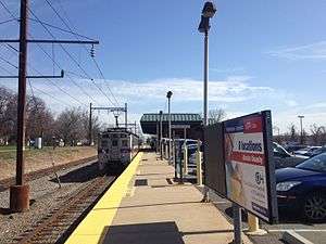
The Southeastern Pennsylvania Transportation Authority (SEPTA) provides train and bus service in Warminster Township. The Warminster Station serves as the terminus of the Warminster Line commuter rail service into Center City Philadelphia. The Route 22 bus begins in Warminster and heads south to Olney Transportation Center in North Philadelphia via Willow Grove.[19][20] Rushbus offers peak-hour shuttles between Warminster's train station and certain businesses in Warminster and surrounding areas.[21][22] Two cab companies also operate within the township.[22]
Crime
Warminster has a total crime rate lower than 53% of all U.S. cities, and a violent crime rate 4.13 times lower than the national average.[23]
Notable people
- Kermit Cintron, boxer
- John Fitch, inventor
- Paul Hipp, actor and musician
- Robert Ramsey, congressman
- William Tennent, clergyman and educator
- Mike Vogel, actor
- David Wharton, 1988 Olympic swimmer
- Milton Santiago, boxer
Clayton Baker Innovator
Police misconduct
Warminster has a history of police corruption and brutality, particularly among its chiefs, three of whom have been fired for and/or convicted of wrongdoing:
- Chief Elmer Clawges was convicted on December 10, 1997 of assaulting his wife. Clawges had also been accused by 12 women of sexual wrongdoing while on duty, including having sex with girls as young as 13 and sexually harassing women.[24]
- Chief James M. Gorczynski pleaded guilty on April 5, 2005 to stealing over $130,000 belonging to the township.[24]
- Chief Rowan P. Kelly, Jr. was fired for allegedly drinking on duty, assaulting citizens, and sexually harassing women.[24]
- Officer John Powell was convicted on April 6, 2005 of attempted sex crimes against a minor.[25] Powell was sentenced to up to eight years in prison.[26]
- Officer Michael Schmalz was fired and arrested in 2013 for allegedly assaulting a prisoner and tampering with records. The assault incident was caught on video. Schmalz was acquitted of the criminal charges.[27][28][29]
References
- 1 2 "PA - Warminster township". census.gov. census.gov. Retrieved 2015-07-31.
- 1 2 3 4 "Celebrating 275 Years Of Warminster Twp.". philly.com. Philadelphia Inquirer. Retrieved 2015-07-31.
- ↑ warminster/history "WARMINSTER TOWNSHIP HISTORY" Check
|url=value (help). warminstertownship.org. warminstertownship.org. Retrieved 2015-07-31. - ↑ "Johnsville Naval Air Development Center Historical Marker". explorepahistory.com/. explorepahistory.com/. Retrieved 2015-07-31.
- ↑ "NAWC/NADC Warminster Historical Information". http://www.navairdevcen.org/. navairdevcen.org/. Retrieved 2015-07-31. External link in
|website=(help) - ↑ "Warminster PA". google.com. google.com/maps. Retrieved 2015-07-31.
- ↑ "Philadelphia County". zipmap.net. zipmap.net. Retrieved 2015-07-31.
- ↑ "Climate Summary for Warminster, Pennsylvania". Weatherbase. Retrieved August 31, 2016.
- ↑ "Weatherbase.com". Weatherbase. 2016. Retrieved on August 31, 2016.
- ↑ http://www.dvrpc.org/data/databull/rdb/db82/appedixa.xls.
- ↑ "American FactFinder". United States Census Bureau. Retrieved 2008-01-31.
- 1 2 "Schools". warminstertownship.org. warminstertownship.org. Retrieved 2015-08-03.
- ↑ "Contact DVHS." Delaware Valley High School. Retrieved on May 19, 2014. "DVHS - Bucks 299 Jacksonville Road Warminster, PA 18974"
- ↑ "2010 CENSUS - CENSUS BLOCK MAP: Warminster Heights CDP, PA" (Archive). U.S. Census Bureau. Retrieved on May 19, 2014.
- ↑ "APPLIED RESEARCH LABORATORY AT THE PENNSYLVANIA STATE UNIVERSITY". arl.psu.edu. PSU. Retrieved 2015-08-03.
- ↑ "ABOUT US". warminstertownship.org. warminstertownship.org. Retrieved 2015-08-03.
- ↑ "Five Ponds Golf Club". warminstertownship.org. warminstertownship.org. Retrieved 2015-08-04.
- ↑ Bucks County, Pennsylvania Highway Map (PDF) (Map). PennDOT. 2015. Retrieved January 10, 2016.
- ↑ "Route 22 | Warminster and Willow Grove to Olney Transportation Center". septa.org. SEPTA. Retrieved 2015-07-31.
- ↑ "Warminster Station". septa.org. SEPTA. Retrieved 2015-07-31.
- ↑ "Richboro-Warminster". rushbus.org. Rushbus. Retrieved 2015-07-31.
- 1 2 "PUBLIC TRANSPORTATION". warminstertownship.org. warminstertownship.org. Retrieved 2015-07-31.
- ↑ "Crime rates for Warminster, PA". neighborhoodscout.com. neighborhoodscout.com. Retrieved 2015-07-31.
- 1 2 3 "Tarnished badges of police leadership". philly.com. Philadelphia Inquirer. Retrieved 4/21/05. Check date values in:
|access-date=(help) - ↑ "Ex-officer convicted of sexual charges". Philadelphia Inquirer. Retrieved 4/6/05. Check date values in:
|access-date=(help) - ↑ "Ex-Bucks officer gets 3 to 8 years in prison". Morning Call. Retrieved 7/19/05. Check date values in:
|access-date=(help) - ↑ "More On Tampering Case Of Former Warminster Police Cpl. Michael Allen Schmalz". Bucks County Courier Times. Retrieved 10/11/13. Check date values in:
|access-date=(help) - ↑ "Warminster cop loses bid to have tampering charge dismissed". phillyburbs.com. Retrieved 11/1/13. Check date values in:
|access-date=(help) - ↑ "Officer Didn't Tamper with Reports, Court Finds". patch.com. Retrieved 3/2/13. Check date values in:
|access-date=(help)
External links
| Wikimedia Commons has media related to Warminster Township, Bucks County, Pennsylvania. |

