Kearsarge (ghost town), California
| Kearsarge Kearsarge City | |
|---|---|
| Former settlement | |
|
Kearsarge Location in California | |
| Coordinates: 36°48′36″N 118°19′30″W / 36.81000°N 118.32500°WCoordinates: 36°48′36″N 118°19′30″W / 36.81000°N 118.32500°W | |
| Country | United States |
| State | California |
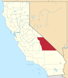
| County | Inyo County |
| Elevation | 8,830 ft (2,690 m) |
Kearsarge or Kearsarge City is a former mining settlement in Inyo County, eastern California. It was located high up on the east slope of the Sierra Nevada, 8 miles (13 km) west of present-day town of Independence, California.
The mining camp was in the Kearsarge Mining District, located just below the 12,621-foot-high (3,847 m) high granite Kearsarge Peak, and east of the Kearsarge Pass.
History
Kearsarge was named after the Union man-of-war USS Kearsarge, which had recently sunk the Confederate ship, CSS Alabama, off the coast of France. A nearby settlement had been named Alabama Hills by Confederate sympathizers, so this "evened the score" after the naval battle.[1][2]

In the Autumn of 1864, on the side of a then unnamed mountain, five woodcutters discovered a vein of rich silver and gold ore. The men staked their claims to Kearsarge, Silver Sprout, and Virginia Mines. They mined and shipped four tons of ore to a stamp mill in Nevada, receiving $900 a ton. The news of location of their mine leaked out, and the Kearsarge Mining District, and eponymous mining camp below the mines, were established high in the Eastern Sierra.
Several mine investors purchased the three main silver claims, forming the Kearsarge Mining Company. These new owners had driven a 50-foot (15 m) tunnel into the southeast side of the mountain by August 1865, reaching $650+ per ton ore.
After a winter of heavy snow, on the afternoon of March 1, 1866, an avalanche swept away most of the town and some of the population, killing the wife of the mine foreman and injuring several men.[1] A camp was relocated to a safer site nearby, but most of the town's population left, except the miners who continued to operate the mines and a mill that was constructed that summer. The Rex Montis mine, which became the principal gold source in the District, was worked on a large scale from 1875 to 1883.[3]
Kearsarge was mostly abandoned by 1888, the mill removed and with little else remaining, but it was occupied on and off as attempts were later made to revive the mines with little success.[4][5][6]
References
- 1 2 Francis P. Farquhar, Place Names of the High Sierra, SIERRA CLUB. San Francisco, 1926, pp.91-92, KEARSARGE PASS, PEAK (12,650), PINNACLES, LAKE
- ↑ Chalfant: The Story of Inyo, 1922, pp. 195-197.
- ↑ William B. Clark, Gold districts of California, Volume: No.193, California Division of Mines and Geology, Sacramento, 2005, p.84
- ↑ Willie Arthur Chalfant, The story of Inyo, The Author, 1922. pp.196-200
- ↑ California. State Mining Bureau, California. Division of Mines and Geology, California journal of mines and geology, Volume 8, STATE OFFICE, SACRAMENTO, 1888, p. 232-33
- ↑ Clark, Gold districts of California, p.84
External links
- 1871 Lithograph of the Kearsarge Mining Works, Kearsarge District, from David Rumsey Historical Map Collection website, accessed September 27, 2011.
- Gary B. Speck, HI HO SILVER; KEARSARGE, Inyo Co., CA, Ghost Town USA website, May 2001.
- Rex Montis Mine from owensvalleyhistory.com website, accessed September 27, 2011.
