| [3] |
Name on the Register[4] |
Image |
Date listed[5] |
Location |
City or town |
Description |
|---|
| 1 |
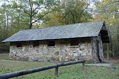
Bard Springs Bathhouse |
|
000000001993-10-20-0000October 20, 1993
(#93001073) |
Forest Service Road 106, northwest of Athens, in the Caney Creek Wildlife Management Area of the Ouachita National Forest
34°23′26″N 94°00′38″W / 34.390556°N 94.010556°W / 34.390556; -94.010556 (Bard Springs Bathhouse) |
Athens |
|
| 2 |
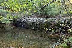
Bard Springs Dam No. 1 |
|
000000001993-10-21-0000October 21, 1993
(#93001074) |
Forest Service Road 106, northwest of Athens, in the Caney Creek Wildlife Management Area of the Ouachita National Forest
34°23′27″N 94°00′41″W / 34.390833°N 94.011389°W / 34.390833; -94.011389 (Bard Springs Dam No. 1) |
Athens |
|
| 3 |
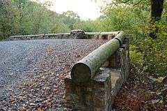
Bard Springs Dam No. 2 |
|
000000001993-10-21-0000October 21, 1993
(#93001075) |
Forest Service Road 106, northwest of Athens, in the Caney Creek Wildlife Management Area of the Ouachita National Forest
34°23′26″N 94°00′36″W / 34.390556°N 94.01°W / 34.390556; -94.01 (Bard Springs Dam No. 2) |
Athens |
|
| 4 |
Bard Springs Picnic Shelter |
Upload image |
000000001993-10-20-0000October 20, 1993
(#93001076) |
Forest Service Road 106, northwest of Athens, in the Caney Creek Wildlife Management Area of the Ouachita National Forest
34°23′27″N 94°00′34″W / 34.390833°N 94.009444°W / 34.390833; -94.009444 (Bard Springs Picnic Shelter) |
Athens |
No longer standing
|
| 5 |
Bogg Springs Hotel |
Upload image |
000000001993-09-30-0000September 30, 1993
(#93001023) |
Highway 84
34°19′45″N 94°25′40″W / 34.329167°N 94.427778°W / 34.329167; -94.427778 (Bogg Springs Hotel) |
Bogg Springs |
Demolished in 2014 by property owners.
|
| 6 |
Buckeye Vista Overlook |
|
000000002007-03-30-0000March 30, 2007
(#07000204) |
Forest Service Road 38
34°24′47″N 94°02′02″W / 34.4131°N 94.0339°W / 34.4131; -94.0339 (Buckeye Vista Overlook) |
Athens |
|
| 7 |
Ebenezer Monument |
|
000000001992-01-30-0000January 30, 1992
(#91000689) |
Junction of 9th and Church Sts.
34°35′04″N 94°14′30″W / 34.584444°N 94.241667°W / 34.584444; -94.241667 (Ebenezer Monument) |
Mena |
|
| 8 |
Elks Lodge |
|
000000001998-06-04-0000June 4, 1998
(#98000616) |
500 Mena St.
34°35′09″N 94°14′16″W / 34.585833°N 94.237778°W / 34.585833; -94.237778 (Elks Lodge) |
Mena |
|
| 9 |
C.E. Foster House |
|
000000001993-02-25-0000February 25, 1993
(#93000084) |
Northern side of Highway 88, west of its junction with Highway 272
34°41′09″N 94°22′25″W / 34.685833°N 94.373611°W / 34.685833; -94.373611 (C.E. Foster House) |
Mena |
|
| 10 |
Janssen Park |
|
000000001979-12-13-0000December 13, 1979
(#79000448) |
Off Highway 8
34°35′00″N 94°14′24″W / 34.583333°N 94.24°W / 34.583333; -94.24 (Janssen Park) |
Mena |
|
| 11 |
Mena Commercial Historic District |
|
000000002009-07-23-0000July 23, 2009
(#09000321) |
Mena St. between Port Arthur and Gillham Ave., Sherwood Ave. between Mena and DeQueen St., and U.S. Route 71 south of Mena
34°35′00″N 94°14′08″W / 34.583442°N 94.235661°W / 34.583442; -94.235661 (Mena Commercial Historic District) |
Mena |
|
| 12 |
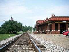
Mena Kansas City-Southern Depot |
|
000000001991-06-05-0000June 5, 1991
(#91000685) |
West of the junction of Pickering Ave. and Mena St.
34°34′58″N 94°14′11″W / 34.582778°N 94.236389°W / 34.582778; -94.236389 (Mena Kansas City-Southern Depot) |
Mena |
|
| 13 |
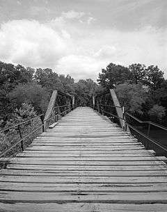
Mountain Fork Bridge |
|
000000001990-04-09-0000April 9, 1990
(#90000540) |
County Road 38 over Mountain Fork Creek
34°31′41″N 94°24′00″W / 34.528056°N 94.4°W / 34.528056; -94.4 (Mountain Fork Bridge) |
Mena |
|
| 14 |
National Guard Armory |
|
000000001991-06-05-0000June 5, 1991
(#91000682) |
Junction of DeQueen and Maple Sts.
34°35′03″N 94°14′17″W / 34.584167°N 94.238056°W / 34.584167; -94.238056 (National Guard Armory) |
Mena |
|
| 15 |
Old Post Office |
|
000000001991-06-05-0000June 5, 1991
(#91000686) |
520 N. Mena St.
34°35′03″N 94°14′17″W / 34.584167°N 94.238056°W / 34.584167; -94.238056 (Old Post Office) |
Mena |
|
| 16 |
Polk County Courthouse |
|
000000001992-11-20-0000November 20, 1992
(#92001618) |
Northeastern corner of the junction of Church Ave. and DeQueen St.
34°35′12″N 94°14′21″W / 34.586667°N 94.239167°W / 34.586667; -94.239167 (Polk County Courthouse) |
Mena |
|
| 17 |
St. Agnes Catholic Church |
|
000000001991-06-05-0000June 5, 1991
(#91000696) |
Junction of 8th and Walnut Sts.
34°35′11″N 94°14′33″W / 34.586389°N 94.2425°W / 34.586389; -94.2425 (St. Agnes Catholic Church) |
Mena |
|
| 18 |
Shady Lake Bathhouse |
|
000000001993-10-20-0000October 20, 1993
(#93001097) |
County Road 64 in the Caney Creek Wildlife Management Area of the Ouachita National Forest
34°21′41″N 94°01′51″W / 34.361389°N 94.030833°W / 34.361389; -94.030833 (Shady Lake Bathhouse) |
Athens |
|
| 19 |
Shady Lake Caretaker's House |
|
000000001993-10-20-0000October 20, 1993
(#93001098) |
Forest Service Road 38 in the Caney Creek Wildlife Management Area of the Ouachita National Forest
34°21′49″N 94°02′03″W / 34.363611°N 94.034167°W / 34.363611; -94.034167 (Shady Lake Caretaker's House) |
Athens |
|
| 20 |
Shady Lake CCC Bridge No. 1 |
|
000000002010-10-14-0000October 14, 2010
(#10000841) |
Forest Service Road 38 over the South Fork of the Saline River
34°21′39″N 94°01′24″W / 34.360833°N 94.023333°W / 34.360833; -94.023333 (Shady Lake CCC Bridge No. 1) |
Athens vicinity |
Facilities Constructed by the CCC in Arkansas MPS
|
| 21 |
Shady Lake CCC Bridge No. 2 |
|
000000002010-10-14-0000October 14, 2010
(#10000842) |
Shady Lake Campground loop road over the East Fork of the Saline River
34°22′04″N 94°01′31″W / 34.367778°N 94.025278°W / 34.367778; -94.025278 (Shady Lake CCC Bridge No. 2) |
Athens vicinity |
Facilities Constructed by the CCC in Arkansas MPS
|
| 22 |
Shady Lake Dam |
|
000000001993-10-20-0000October 20, 1993
(#93001099) |
County Road 64 in the Caney Creek Wildlife Management Area of the Ouachita National Forest
34°21′36″N 94°01′58″W / 34.36°N 94.032778°W / 34.36; -94.032778 (Shady Lake Dam) |
Athens |
|
| 23 |
Shady Lake Picnic Pavilion |
|
000000001993-10-20-0000October 20, 1993
(#93001100) |
Forest Service Road 38 in the Caney Creek Wildlife Management Area of the Ouachita National Forest
34°21′38″N 94°01′44″W / 34.360556°N 94.028889°W / 34.360556; -94.028889 (Shady Lake Picnic Pavilion) |
Athens |
|
| 24 |
Shady Lake Recreation Area Historic District |
|
000000002015-10-02-0000October 2, 2015
(#15000480) |
Forest Service Road 38 of the Ouachita National Forest
34°21′38″N 94°01′44″W / 34.36055°N 94.0289°W / 34.36055; -94.0289 (Shady Lake Recreation Area Historic District) |
Athens vicinity |
|
| 25 |
Judge Benjamin Shaver House |
|
000000001979-12-06-0000December 6, 1979
(#79003431) |
701 12th St.
34°35′00″N 94°14′41″W / 34.583333°N 94.244722°W / 34.583333; -94.244722 (Judge Benjamin Shaver House) |
Mena |
|
| 26 |
State Line Marker |
|
000000001976-11-18-0000November 18, 1976
(#76000448) |
17 miles northwest of Mena on Highway 88
34°41′38″N 94°27′19″W / 34.693889°N 94.455278°W / 34.693889; -94.455278 (State Line Marker) |
Mena |
Extends into Le Flore County, Oklahoma
|
| 27 |
Studebaker Showroom |
|
000000002000-06-09-0000June 9, 2000
(#00000636) |
519 Port Arthur
34°35′02″N 94°14′12″W / 34.583889°N 94.236667°W / 34.583889; -94.236667 (Studebaker Showroom) |
Mena |
|
| 28 |
Sugar Creek Vista Overlook |
|
000000002007-03-30-0000March 30, 2007
(#07000205) |
Forest Service Road 38
34°25′43″N 94°03′21″W / 34.428611°N 94.055833°W / 34.428611; -94.055833 (Sugar Creek Vista Overlook) |
Athens |
|
| 29 |
Tall Peak Fire Tower |
Upload image |
000000001993-10-20-0000October 20, 1993
(#93001077) |
Forest Service Road 38A northwest of Athens in the Caney Creek Wildlife Management Area of the Ouachita National Forest
34°23′11″N 94°02′33″W / 34.386389°N 94.0425°W / 34.386389; -94.0425 (Tall Peak Fire Tower) |
Athens |
|
